User talk:Hel-hama
Tip: Categorizing images[edit]

Thanks a lot for contributing to the Wikimedia Commons! Here's a tip to make your uploads more useful: Why not add some categories to describe them? This will help more people to find and use them.
Here's how:
1) If you're using the UploadWizard, you can add categories to each file when you describe it. Just click "more options" for the file and add the categories which make sense:

2) You can also pick the file from your list of uploads, edit the file description page, and manually add the category code at the end of the page.
[[Category:Category name]]
For example, if you are uploading a diagram showing the orbits of comets, you add the following code:
[[Category:Astronomical diagrams]][[Category:Comets]]
This will make the diagram show up in the categories "Astronomical diagrams" and "Comets".
When picking categories, try to choose a specific category ("Astronomical diagrams") over a generic one ("Illustrations").
Thanks again for your uploads! More information about categorization can be found in Commons:Categories, and don't hesitate to leave a note on the help desk.CategorizationBot (talk) 11:13, 27 July 2011 (UTC)
- Image:Woolsthorpe Manor.jpg was uncategorized on 26 July 2011 CategorizationBot (talk) 11:13, 27 July 2011 (UTC)
- Image:Wuffing dynasty Tytila.png was uncategorized on 4 August 2011 CategorizationBot (talk) 11:55, 5 August 2011 (UTC)
- Image:Viola or violin.svg was uncategorized on 4 August 2011 CategorizationBot (talk) 11:55, 5 August 2011 (UTC)
- Image:Wuffing dynasty Wehha.png was uncategorized on 10 August 2011 CategorizationBot (talk) 12:07, 11 August 2011 (UTC)
- Image:Tribal Hidage.svg was uncategorized on 13 August 2011 CategorizationBot (talk) 11:47, 14 August 2011 (UTC)
- Image:Cambridgeshire dykes.svg was uncategorized on 24 November 2011 CategorizationBot (talk) 11:46, 25 November 2011 (UTC)
- Image:Castle icon.svg was uncategorized on 12 December 2011 CategorizationBot (talk) 11:09, 13 December 2011 (UTC)
Cnut[edit]
Thanks for your lovely maps. I note you omit Devon and Cornwall from <Cnut lands.svg>. Do you have evidence for this? Brownturkey (talk) 08:29, 3 December 2019 (UTC)

|
File:Libyan_Uprising.svg has been listed at Commons:Deletion requests so that the community can discuss whether it should be kept or not. We would appreciate it if you could go to voice your opinion about this at its entry.
If you created this file, please note that the fact that it has been proposed for deletion does not necessarily mean that we do not value your kind contribution. It simply means that one person believes that there is some specific problem with it, such as a copyright issue. Please see Commons:But it's my own work! for a guide on how to address these issues. |
92.100.172.117 05:28, 22 September 2011 (UTC)
|
|
File:Libyan_Uprising.svg has been listed at Commons:Deletion requests so that the community can discuss whether it should be kept or not. We would appreciate it if you could go to voice your opinion about this at its entry.
If you created this file, please note that the fact that it has been proposed for deletion does not necessarily mean that we do not value your kind contribution. It simply means that one person believes that there is some specific problem with it, such as a copyright issue. Please see Commons:But it's my own work! for a guide on how to address these issues. |
92.100.172.117 05:30, 22 September 2011 (UTC)
Map errors[edit]
Hello. I've noticed a minor spelling mistake on the maps File:England diocese map pre-925.svg and File:England diocese map post 950.svg. It should be Sherborne (not Sherbourne). Also on File:Anglo-Saxon burhs.svg it should be Shaftesbury (not Shaftsbury). Regards. BarretBonden (talk) 15:09, 31 July 2012 (UTC)
- sorted. Hel-hama (talk) 15:00, 4 August 2012 (UTC)
- Thanks. BarretBonden (talk) 18:08, 6 August 2012 (UTC)
- Also, on File:Anglo-Saxon Wessex.svg - "South Moulton" should be South Molton, "Sherbourne" should be Sherborne, "Sherborne" (sic) should be Shaftesbury, and "Wimbourne" should be Wimborne. Great map, though - thanks for your work! Ghmyrtle (talk) 21:47, 8 August 2012 (UTC) PS: In addition, South Molton is wrongly located - it should be a few miles ESE of where it is shown, which is the site of Barnstaple. Ghmyrtle (talk) 07:22, 9 August 2012 (UTC)
- sorted, thanks Ghmyrtle. Hel-hama (talk) 14:34, 9 August 2012 (UTC)
- Thank you! Ghmyrtle (talk) 09:41, 17 August 2012 (UTC)
- sorted, thanks Ghmyrtle. Hel-hama (talk) 14:34, 9 August 2012 (UTC)
- Also, on File:Anglo-Saxon Wessex.svg - "South Moulton" should be South Molton, "Sherbourne" should be Sherborne, "Sherborne" (sic) should be Shaftesbury, and "Wimbourne" should be Wimborne. Great map, though - thanks for your work! Ghmyrtle (talk) 21:47, 8 August 2012 (UTC) PS: In addition, South Molton is wrongly located - it should be a few miles ESE of where it is shown, which is the site of Barnstaple. Ghmyrtle (talk) 07:22, 9 August 2012 (UTC)
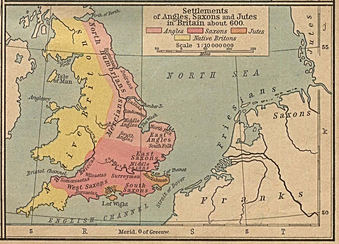
Map of peoples of Britain circa 600[edit]
Hi there. I noticed a comment made at en-Wikipedia about File:Britain peoples circa 600.svg. I've commented there, but wanted to ask some questions here as well.
- (1) What source is being used for the coastline detail in the 8 July 2012 edit?
- (2) Shouldn't you be credited as the author of this work, and not User:Wereon? The file history credits you with the most recent edit, but the file page licensing information wasn't updated and still lists the author as User:Wereon and includes references to User:IMeowbot, border data from CIA, people locations from The Historical Atlas by William R. Shepherd, 1926 edition, and clarifications from en:User:Everyking per references used in en:Penda of Mercia. As far as I can tell, your edit of June 2012 is also (like User:Wereon's version) a derivative of Shepherd 1926, but making different choices. It might have been better to do that as a separate upload rather than overwriting the existing image.
I'm not 100% on that last bit, so would you mind me checking this with some other editors? Carcharoth (Commons) (talk) 04:56, 4 September 2012 (UTC)
- Just following this up, as I'm not sure if you saw the above when you last edited, though you did edit the day after I left the message. I'm not on Commons very often, so if you could say whether you got the message or not, that would help. Thanks. Carcharoth (Commons) (talk) 23:48, 7 September 2012 (UTC)
- Hi Carcharoth, I've amended the caption accordingly. Thanks. Hel-hama (talk) 15:14, 8 September 2012 (UTC)
- Thanks for the reply. Would you have time to add the source for the "sea, swamp and alluvium" area that you added in the edit you made for the 8 July 2012 for that map? It is a bit puzzling for anyone trying to work out where that level of detail comes from, and it's not clear if those large grey areas along the estuaries of the Humber and the Wash are inhabited or not. Carcharoth (Commons) (talk) 21:07, 8 September 2012 (UTC)
- I've amended the caption again to explain the coastline is from Hill, and what it signifies. Hel-hama (talk) 10:14, 9 September 2012 (UTC)
- That's very helpful. Thanks! Carcharoth (Commons) (talk) 16:49, 9 September 2012 (UTC)
- I've amended the caption again to explain the coastline is from Hill, and what it signifies. Hel-hama (talk) 10:14, 9 September 2012 (UTC)
- Thanks for the reply. Would you have time to add the source for the "sea, swamp and alluvium" area that you added in the edit you made for the 8 July 2012 for that map? It is a bit puzzling for anyone trying to work out where that level of detail comes from, and it's not clear if those large grey areas along the estuaries of the Humber and the Wash are inhabited or not. Carcharoth (Commons) (talk) 21:07, 8 September 2012 (UTC)
- Hi Carcharoth, I've amended the caption accordingly. Thanks. Hel-hama (talk) 15:14, 8 September 2012 (UTC)
Hello Hel-hama when you cropped the picture of frankish arms and armours, you removed one weapon which is mentioned in the descripton on commons and several other wikipedia entries using that picture. Now there are only five items while six are mentioned in the description. 82.113.121.53 04:29, 24 October 2012 (UTC)
I think the more usual spellings are "Khazars" and "Mordvinians"... AnonMoos (talk) 11:52, 2 January 2013 (UTC)
This message was added automatically by Nikbot, if you need some help about it please read the text above again and follow the links in it, if you still need help ask at the ![]() → Commons:Help desk in any language you like to use. --Nikbot 08:58, 19 January 2013 (UTC)
→ Commons:Help desk in any language you like to use. --Nikbot 08:58, 19 January 2013 (UTC)
Europe_814.svg[edit]
This file has an inaccurate part compared to File:Europe 814.jpg in the label "Chrobatia". The label should be placed south of the line indicating the Sava river, not north of it. The overall strict border delineation is a bonkers aspect of the original, but at least keep true to that original. --Joy (talk) 14:48, 6 February 2013 (UTC)
Also, the widely-spaced label "Slaves" across the western Balkans is missing. --Joy (talk) 14:49, 6 February 2013 (UTC)
Greyfriars, Leicester map[edit]
Your work on the Greyfriars map has produced a very smart result. However, the location of Leicester Cathedral, which was on the original, is not marked. It is highly relevant to the 'Exhumation' page, so would be good to be properly indicated.
Also, although you acknowledge the gif file, it is not linked, and you have not included any of the previous licence or source information. It is a specific requirement of the OS Opendata licence to carry the licence through to all derived sources. Also, the other information is from cited sources that are not now included on your map - it simply says 'Own Work'. Could you copy over all the relevant sources, so that it is apparent where the content is coming from. Thanks, RobinLeicester (talk) 02:45, 4 March 2013 (UTC)
Europe 814[edit]
Hi Hel-hama. Your map shows incorrectly the islands of Saaremaa and Hiiumaa, as well as the northern tip of Courland as ethnically/politically Swedish/Gothic. In the ninth century and before that there were no Scandinavians in any of these areas. Please correct the coloration and change it to yellow, which you seem to have been using as a generic for Finno-Ugric tribes. --Vihelik (talk) 19:57, 12 July 2013 (UTC)
'Angeln' map (Angeln.svg )[edit]
Hi
The map has misspelling: it should be Eckernförde.
The map shows no connection through to the Baltic Sea at Kappeln - but there is! That geography is very important to the history of the area.
- the missing mouth of the Schlei at Kappeln is still not fixed 47.71.67.26 15:56, 27 October 2018 (UTC)
I may be wrong, but I believe Northumbria was part of the Danelaw by 878. Also, in 879 Wessex took over Mercia, therefore all of the English Kingdoms (apart from those under Danish rule) were client states of Wessex. Therefore I think it would be more appropriate to have a map of 879, showing the two parts of England, before the unified state was formed. If you can, I would appreciate it if you could make these changes to your fabulous map. Thanks, Rob (talk) 14:10, 20 October 2013 (UTC)
Benjamin Britten's birthplace[edit]
Warmest thanks for adding this photograph, which was exactly what the English WP article needed. Bless you! Tim riley (talk) 00:04, 24 November 2013 (UTC)
|
|
File:Europe 814.svg has been listed at Commons:Deletion requests so that the community can discuss whether it should be kept or not. We would appreciate it if you could go to voice your opinion about this at its entry.
If you created this file, please note that the fact that it has been proposed for deletion does not necessarily mean that we do not value your kind contribution. It simply means that one person believes that there is some specific problem with it, such as a copyright issue. Please see Commons:But it's my own work! for a guide on how to address these issues. |
Hchc2009 (talk) 08:30, 27 November 2014 (UTC)
|
|
File:Tripolitanian Front.svg has been listed at Commons:Deletion requests so that the community can discuss whether it should be kept or not. We would appreciate it if you could go to voice your opinion about this at its entry.
If you created this file, please note that the fact that it has been proposed for deletion does not necessarily mean that we do not value your kind contribution. It simply means that one person believes that there is some specific problem with it, such as a copyright issue. Please see Commons:But it's my own work! for a guide on how to address these issues. |
Archer90 (talk) 12:28, 27 June 2015 (UTC)
File:Greyfriars,_Leicester_site.svg[edit]
Hi, I think this file needs to be changed. First "present buildings" is unclear, as nobody knows what "present" is. Today - 2018 - the google air view shows completely different buildings including the new Richard III visitor centre. As this is directly over the burial site, he spot is not at the correct place as well. 47.71.37.1 18:00, 24 October 2018 (UTC)
Main Map inaccuracy[edit]
https://en.wikipedia.org/wiki/Early_Middle_Ages
The main map shows Principality of Serbia as Servia spanning over Bosnia yet not only is the Croatia Dutchy missing but Bosnia was in the Croatia Dutchy at this time. The map needs to be fixed. It doesn’t align with the established borders of Serbia and Croatia.Cite error: Invalid <ref> tag; refs with no name must have content OyMosby (talk) 22:04, 8 January 2020 (UTC)
File:Map_of_River_Niger.svg[edit]
Hi, thank you for your maps. On the Niger river map it seems like the river originates in Sierra Leone when in fact it doesn't. Could you create a version that fixes this? Thanks.--37.201.182.206 15:47, 11 January 2022 (UTC)
- It's on my list of jobs! Amitchell125 (talk) 16:15, 11 January 2022 (UTC)
- Thank you very much, I appreciate it!--37.201.182.206 20:21, 13 January 2022 (UTC)