User:Sting/Gallery: Maps of the world, of seas and about history
| My images galleries |
|---|
| Maps: Maps of the world, of seas and about history - Regional maps - Location and locator maps -- go back to my main user page -- |
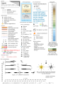
Welcome in my gallery of maps of the world, of seas and about history. All maps here were created by myself (Eric Gaba, as username Sting).

I authorize anybody to use my photographs, maps or schemes outside the Wikimedia projects (Wikipedia in different languages, Commons, Wikibooks, Wikisource, etc.), on an other Web site or in publications, for commercial or non-commercial use. No written authorization is necessary, as long as you respect the terms of the license under which the image is publicized (especially that I am credited as author, when required), but a message from you on my discussion page with a reply address would be greatly appreciated.
![]() This user is a Wikigraphist from the Atelier graphique to whom you can propose images or maps to improve.
This user is a Wikigraphist from the Atelier graphique to whom you can propose images or maps to improve.
-
 Template for standard map creation

Map projections[edit]
-

-
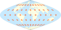
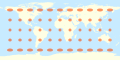 World map in an equirectangular projection with Tissot's Indicatrices of deformation
 -
 World map in a Mercator projection with Tissot's Indicatrices of deformation
 -
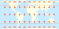
 World map in a Lambert cylindrical equal-area projection with Tissot's Indicatrices
 -
 World map in a Behrmann cylindrical equal-area projection with Tissot's Indicatrices
 -
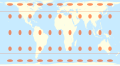
 World map in a Smyth-Craster cylindrical equal-area projection with Tissot's Indicatrices
 -
 World map in a Trystan Edwards cylindrical equal-area projection with Tissot's Indicatrices
 -
 World map in a Hobo-Dyer cylindrical equal-area projection with Tissot's Indicatrices
 -
 World map in an unnamed 40 deg cylindrical equal-area projection with Tissot's Indicatrices
 -
 World map in a Gall-Peters cylindrical equal-area projection with Tissot's Indicatrices
 -
 World map in a Balthasart cylindrical equal-area projection with Tissot's Indicatrices
 -
 World map in a Tobler cylindrical equal-area projection with Tissot's Indicatrices
 -
 World map in a Mollweide projection with Tissot's Indicatrices
 -
 World map in a Robinson projection with Tissot's Indicatrices
 -
 World map in a Winkel tripel projection with Tissot's Indicatrices
 -
 World map in a sinusoidal projection with Tissot's Indicatrices


World maps[edit]
Blank[edit]
-
 World map in a sinusoidal projection (centered on Prime Meridian)
 -
 World map in a Winkel tripel projection (centered on Prime Meridian)


Tectonic plates[edit]
-

-

-

-
 Physical map of the tectonic plates (10°E centered)
Also : in French -
 Map of the tectonic plates (180°E centered)
Also : in French;
Former version in Mercator projection in English and in French -
 Physical map of the tectonic plates (180°E centered)
Also : in French


Miscellaneous[edit]

Maps of Seas[edit]
-
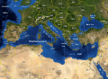
 Map of OSPAR Commission area
 -
-

-
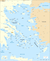 Full SVG map of the Aegean Sea
 -
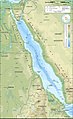 Topographic / bathymetric map of the Red Sea
Also : SVG version
raster version in English
SVG version in English
Blank and flat map -

-
 Geographical distribution of the Ascophyllum nodosum
 -
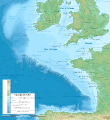 Bathymetry of the Celtic Sea and the Bay of Biscay


Maps about history[edit]
-
 General map for the battle of Delium
Also in Spanish -
 Detail map for the battle of Delium
Also in Spanish -

-
 Map of the French expedition in Peloponnese between 1828 and 1833
 -
 General map for the siege of Missolonghi
 -
 Map of Peloponnese during the Middle Ages
 -
 Battle of Greece (WWII - April 1941)
Also: in French -
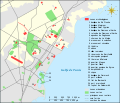
 Cretan archaeological sites
 -
 Map of the military operations during the Ionian Revolt
 -

-
 Map of Southern Italy for the Pyrrhic War
 -
 Map of the archaeological ruins in Carthage
 -
-

-
 Rennes at the early 17th century according to Henri Carré


