Maps of South Korean divisions
Jump to navigation
Jump to search
Following maps are ordered by Administrative district region classification code(행정구역분류코드).
- Buk=north, Nam=south, Seo=west, Dong=east, Jung=central
Seoul Special (Metropolitan) City[edit]
-
 Administrative map of Seoul

Districts of Seoul Special (Metropolitan) City[edit]
-
 Jongno District
 -
 Jung District
 -
 Yongsan District
 -
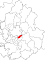
 Seongdong District
 -
 Gwangjin District
 -
 Dongdaemun District
 -
 Jungnang District
 -
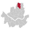
 Seongbuk District
 -
 Gangbuk District
 -
 Dobong District
 -
 Nowon District
 -
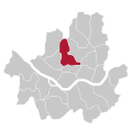
 Eunpyeong District
 -
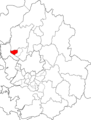
 Seodaemun District
 -
 Mapo District
 -
 Yangcheon District
 -
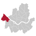 Gangseo District
 -
 Guro District
 -
 Geumcheon District
 -
 Yeongdeungpo District
 -
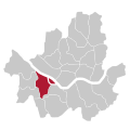
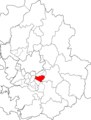
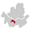 Dongjak District
 -
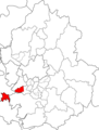
 Gwanak District
 -
 Seocho District
 -
 Gangnam District
 -
 Songpa District
 -
 Gangdong District


Busan Metropolitan City[edit]
-
 Administrative map of Busan

Districts and counties of Busan Metropolitan City[edit]
-
 Jung District
 -
 Seo District
 -
 Dong District
 -
 Yeongdo District
 -
 Busanjin District
 -
 Dongnae District
 -
 Nam District
 -
 Buk District
 -
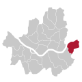
 Haeundae District
 -
 Saha District
 -
 Geumjeong District
 -
 Gangseo District
 -
 Yeonje District
 -
 Suyeong District
 -
 Sasang District
 -
 Gijang County


Daegu Metropolitan City[edit]
-
 Administration map (Old version without Gunwi)
 -
 Administration map (Simplified version)


District and County of Daegu Metropolitan City[edit]
-
 Jung District (DAEGU)
 -
 Dong District (DAEGU)
 -
 Seo District (DAEGU)
 -
 Nam District (DAEGU)
 -
 Buk District (DAEGU)
 -
 Suseong District
 -
 Dalseo District
 -
 Dalseong County
 -
 Gunwi County


Incheon Metropolitan City[edit]
-
 Administration map (Original version)
 -
 Administration map (Simplified version)


District and County of Incheon Metropolitan City[edit]
-
 Jung District (INCHEON)
 -
 Dong District (INCHEON)
 -
 Michuhol District
 -
 Yeonsu District
 -
 Namdong District
 -
 Bupyeong District
 -
 Gyeyang District
 -
 Seo District (INCHEON)
 -
 Ganghwa County
 -
 Ongjin County (INCHEON)


Gwangju Metropolitan City[edit]
-
 Administration map (Original version)
 -
 Administration map (Simplified version)


District of Gwangju Metropolitan City[edit]
-
 Dong District (GWANGJU)
 -
 Seo District (GWANGJU)
 -
 Nam District (GWANGJU)
 -
 Buk District (GWANGJU)
 -
 Gwangsan District
.svg)
.svg)
.svg)
.svg)

Daejeon Metropolitan City[edit]
-
 Administration map (Original version)
 -
 Administration map (Simplified version)


District of Daejeon Metropolitan City[edit]
-
 Dong District (DAEJEON)
 -
 Jung District (DAEJEON)
 -
 Seo District (DAEJEON)
 -
 Yuseong District
 -
 Daedeok District


Ulsan Metropolitan City[edit]
-
 Administration map (Original version)
 -
 Administration map (Simplified version)


District and County of Ulsan Metropolitan City[edit]
-
 Jung District (ULSAN)
 -
 Nam District (ULSAN)
 -
 Dong Disrict (ULSAN)
 -
 Buk District (ULSAN)
 -
 Ulju County


Sejong Special Autonomous City[edit]

Gyeonggi Province[edit]
-
 Administration map (Original version)
 -
 Administration map (Simplified version)


City, District and County of Gyeonggi Province[edit]
-
 Suwon city
 -
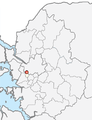
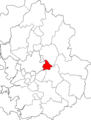
 Seongnam city
 -
 Uijeongbu city
 -
 Anyang city
 -
 Bucheon city
 -
 Gwangmyeong city
 -
 Pyeongtaek city
 -
 Dongducheon city
 -
 Ansan city
 -
 Goyang city
 -
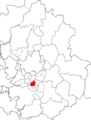
 Gwacheon city
 -
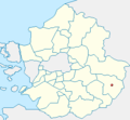
 Guri city
 -
 Namyangju city
 -
 Osan city
 -
 Siheung city
 -
 Gunpo city
 -
 Uiwang city
 -
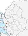
 Hanam city
 -
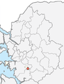
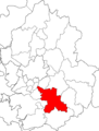 Yongin city
 -
 Paju city
 -
 Icheon city
 -
 Anseong city
 -
 Gimpo city
 -
 Hwaseong city
 -
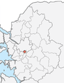
 Gwangju city
 -
 Yangju city
 -
 Pocheon city
 -
 Yeoju county
 -
 Yeoncheon county
 -
 Gapyeong county
 -
 Yangpyeong county
 -
Ongjin County (INCHEON)


District of Suwon-si[edit]
-
 Jang-an District
 -
 Gwonseon District
 -
 Paldal District
 -
 Yeongtong District


District of Seongnam-si[edit]
-
 Sujeong District
 -
 Jung-won District
 -
 Bundang District


District of Anyang-si[edit]
-
 Manan District
 -
 Dong-an District


District of Bucheon-si[edit]
-
 Wonmi District
 -
 Sosa District
 -
 O-jeong District


District of Ansan-si[edit]
-
 sangnok District
 -
 Dan-won District


District of Goyang-si[edit]
-
 Deogyang District
 -
 Ilsan-dong (Ilsan East) District
 -
 Ilsan-seo (Ilsan West) District


District of Yong'in-si[edit]
-
 Cheoin District
 -
 Giheung District
 -
 Suji District


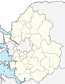
Gangwon Province[edit]
-
 Administration map

City and County of Gangwon Province[edit]
-
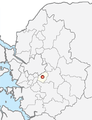
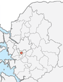
 Chuncheon city
 -
 Donghae city
 -
 Wonju city
 -
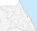 Gangneung city
 -
 Taebaek city
 -
 Sokcho city
 -
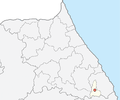
 Samcheok city
 -
 Hongcheon county
 -
 Hoengseong county
 -
 Yeongwol county
 -
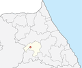
 Pyeongchang county
 -
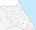 Jeongseon county
 -
 Cheorwon county
 -
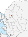
 Hwacheon county
 -
 Yanggu county
 -
 Inje county
 -
 Goseong county (South Gangwon)
 -
 Yangyang county


Chungcheongbuk Province[edit]
-
 Administration map (Original version)
 -
 Administration map (Simplified version)


City and County of Chungcheongbuk Province[edit]
-
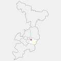
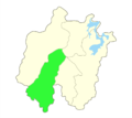
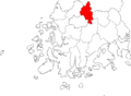
 Cheongju city
 -
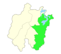
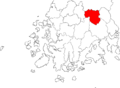
 Chungju city
 -
 Jecheon city
 -
 Boeun county
 -
 Danyang county
 -
 Eumseong county
 -
 Goesan county
 -
 Jeungpyeong county
 -
 Jincheon county
 -
 Okcheon county
 -
 Yeongdong county
 -
 Cheongwon county (Abolished)


District of Cheongju-si[edit]
-
 Sangdang District
 -
 Heungdeok District


Chungcheongnam Province[edit]
-
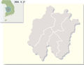
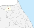
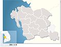
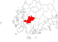
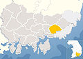
 Map of Chungcheongnam Province Highlighted
 -
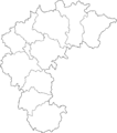
 Administration map (Original version)
 -
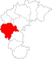
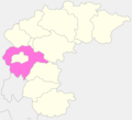
 Administration map (Simplified version)


City and County of Chungcheongnam Province[edit]
-
 Asan city
 -
 Boryeong city
 -
 Buyeo county
 -
 Cheonan city
 -
 Geumsan county
 -
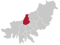
 Gongju city
 -
 Gyeryong city
 -
 Nonsan city
 -
 Seosan city
 -
 Cheongyang county
 -
 Dangjin county
 -
 Hongseong county
 -
 Seocheon county
 -
 Taean county
 -
 Yesan county
 -
 Yeongi county(abolished)


Jeollabuk Province[edit]
-
 Administration map (Original version)
 -
 Administration map (Simplified version)


City and County of Jeollabuk Province[edit]
-
 Jeonju city
 -
 Gimje city
 -
 Gunsan city
 -
 Jeongeup city
 -
 Namwon city
 -
 Iksan city
 -
 Buan county
 -
 Gochang county
 -
 Imsil county
 -
 Jangsu county
 -
 Jinan county
 -
 Muju county
 -
 Sunchang county
 -
 Wanju county


District of Jeonju-si[edit]
-
 Wansan District
 -
 Deokjin District


Jeollanam Province[edit]
-
 Administration map (Original version)
 -
 Administration map (Simplified version)


City and County of Jeollanam Province[edit]
-
 Gwangyang city
 -
 Mokpo city
 -
 Naju city
 -
 Suncheon city
 -
 Yeosu city
 -
 Boseong county
 -
 Damyang county
 -
 Gangjin county
 -
 Goheung county
 -
 Gokseong county
 -
 Gurye county
 -
 Haenam county
 -
 Hampyeong county
 -
 Jangheung county
 -
 Jangseong county
 -
 Jindo county
 -
 Muan county
 -
 Sinan county
 -
 Wando county
 -
 Yeongam county
 -
 Yeonggwang county


Gyeongsangbuk Province[edit]
-
 Administration map (Original version)
 -
 Administration map (Simplified version)


City and County of Gyeongsangbuk Province[edit]
-
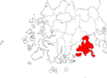
 Pohang city
 -
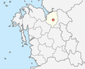
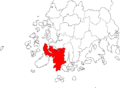
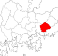
 Gyeongju city
 -
 Gimcheon city
 -
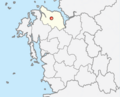
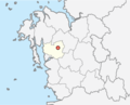
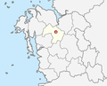
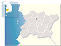
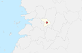
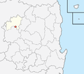
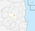
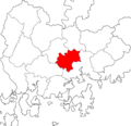
 Andong city
 -
 Gumi city
 -
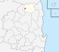
 Yeongju city
 -
 Yeongcheon city
 -
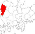
 Sangju city
 -
 Mungyeong city
 -
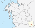
 Gyeongsan city
 -
 Gunwi county
 -
 Uiseong county
 -
 Cheongsong county
 -
 Yeongyang county
 -
 Yeongdeok county
 -
 Cheongdo county
 -
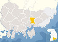
 Goryeong county
 -
 Seongju county
 -
 Chilgok county
 -
 Yecheon county
 -
 Bonghwa county
 -
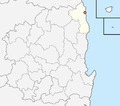 Uljin county
 -
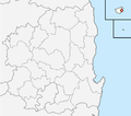 Ulleung county


District of Pohang-si[edit]
-
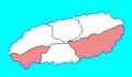
 Nam (South) District
 -
 Buk (North) District


Gyeongsangnam Province[edit]
-
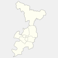
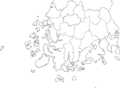
 Administration map (Original version)
 -
 Administration map (Simplified version)


City and County of Gyeongsangnam Province[edit]
-
 Changwon city
 -
 Changwon city
 -
 Geoje city
 -
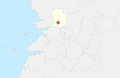
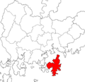
 Gimhae city
 -
 Gimhae city
 -
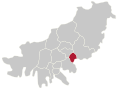
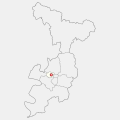
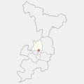
 Jinhae city
 -
 Jinhae city
 -
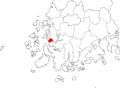
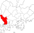
 Jinju city
 -
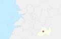
 Miryang city
 -
 Sacheon city
 -
 Tongyeong city
 -
 Tongyeong city
 -
 Yangsan city
 -
 Changnyeong county
 -
 Geochang county
 -
 Goseong county
 -
 Goseong county Detail
 -
 Hadong county
 -
 Haman county
 -
 Hamyang county
 -
 Hapcheon county
 -
 Namhae county
 -
 Sancheong county
 -
 Uiryeong county


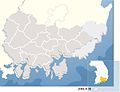
Jeju Province[edit]
-
 Administration map (Original version)

City and County of Jeju Province[edit]
-
 Jeju city
 -
 Seogwipo city
 -
 Bukjeju county(abolished)
 -
 Namjeju county(abolished)


