File:Map of Transcontiental nations.png
Jump to navigation
Jump to search

Size of this preview: 800 × 351 pixels. Other resolutions: 320 × 140 pixels | 640 × 281 pixels | 1,425 × 625 pixels.
Original file (1,425 × 625 pixels, file size: 40 KB, MIME type: image/png)
Captions
Captions
Add a one-line explanation of what this file represents
Misspelt title of map: Transcontiental>Transcontinental
Only two shades of blue distinguishable.
Summary[edit]
| Description |
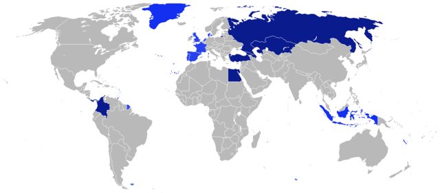
Afrikaans: Kaart van Transkontinentale nasies.
state met 'n aangrensende grens
state met 'n nie-aangrensende grens
state met 'n gebied wat transkontinentale Dansk: Kort over transkontinentale nationer.
stater med en sammenhængende grænse.
stater med en ikke-sammenhængende grænse.
stater med et område, der er transkontinentale. English: Map of transcontinental nations.
states with a contiguous boundary.
states with a non-contiguous boundary.
states with a territory that's transcontinental. Español: Mapa de las naciones transcontinental.
estados con un límite contigua.
estados con un límite no contigua.
Estados con un área de Transcontinental. Français : Carte des pays transcontinentaux.
pays ayant une continuité territoriale de ses frontières.
pays sans continuité territoriale de ses frontières.
pays ayant un territoire transcontinental. Nederlands: Kaart van Transcontinentale naties.
staten met een aangrenzende grens.
staten met een niet-aangrenzende grens.
staten met een gebied dat transcontinentaal is. Türkçe: Kıtalararası Ülkeler.
Bitişik sınır ülkeleri.
Sınırı bitişik olmayan ülkeler.
Denizaşırı toprağı bulunan ülkeler. Русский: Карта Трансконтинентальных стран.
Государства с примыкающей границей.
Государства с несмежной границей.
Государства с Трансконтинентальной площадью. العربية : خريطة الدول عابرة للقارات.
الدول التي لها حدود متماسك.
الدول التي لها حدود غير متجاورة.
الدول التي لديها أراضي هذا هو عابر للقارات. |
| Date | |
| Source | Own work |
| Author | $200inaire |
Licensing[edit]
I, the copyright holder of this work, hereby publish it under the following license:
This file is licensed under the Creative Commons Attribution-Share Alike 3.0 Unported license.
- You are free:
- to share – to copy, distribute and transmit the work
- to remix – to adapt the work
- Under the following conditions:
- attribution – You must give appropriate credit, provide a link to the license, and indicate if changes were made. You may do so in any reasonable manner, but not in any way that suggests the licensor endorses you or your use.
- share alike – If you remix, transform, or build upon the material, you must distribute your contributions under the same or compatible license as the original.
File history
Click on a date/time to view the file as it appeared at that time.
| Date/Time | Thumbnail | Dimensions | User | Comment | |
|---|---|---|---|---|---|
| current | 19:41, 4 August 2014 | | 1,425 × 625 (40 KB) | KronosLine (talk | contribs) | Added South Sudan, removed Kosovo (either include all breakaway regions or none) |
| 10:32, 5 April 2014 |  | 1,425 × 625 (33 KB) | SeeSchloss (talk | contribs) | Added French overseas territories (French Guyana, Southern territories, St Pierre & Miquelon, Guadeloupe, Martinique, Réunion, Mayotte, New Caledonia, Wallis & Futuna - I couldn't spot French Polynesia islands on the map) as well as Corsica. Added Spa... | |
| 04:09, 25 February 2014 |  | 1,425 × 625 (40 KB) | Scoelho86 (talk | contribs) | +POR | |
| 04:33, 31 January 2014 |  | 1,425 × 625 (40 KB) | Scoelho86 (talk | contribs) | +COL | |
| 07:48, 13 June 2012 |  | 1,425 × 625 (57 KB) | $200inaire (talk | contribs) | Fix some errors and flaws in the map | |
| 23:16, 10 June 2012 |  | 1,425 × 625 (56 KB) | $200inaire (talk | contribs) |
You cannot overwrite this file.
File usage on Commons
There are no pages that use this file.
File usage on other wikis
The following other wikis use this file:
- Usage on arz.wikipedia.org
- Usage on da.wikipedia.org
- Usage on la.wikipedia.org
- Usage on ml.wikipedia.org