File:Kalchreuth Sperkquelle 1843.tiff

Original file (6,359 × 3,759 pixels, file size: 135.7 MB, MIME type: image/tiff)
Captions
Captions
Summary[edit]
| Description |
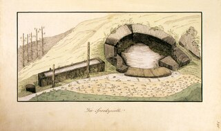
Deutsch: An dieser Stelle fand wahrscheinlich die erste Besiedlung von Kalchreuth im Hochmittelalter statt. Die Quelle befindet sich südlich von der Straße "Am Spirkbrunnen" und ist in der topografischen Karte des Bayernatlas verzeichnet. |
| Date | |
| Source |
Statistik von Kalchreuth, gefertigt von Dr. Karl Gottlob Rehlen im Jahre 1843 im Bestand des Pfarramtarchivs von Kalchreuth. Das Buch enthält 16 Zeichnungen der Örtlichkeiten von Kalchreuth. Der Autor ist unbekannt. |
| Author | Unknown author |
Licensing[edit]
|
This work is in the public domain in its country of origin and other countries and areas where the copyright term is the author's life plus 70 years or fewer.
| |
| This file has been identified as being free of known restrictions under copyright law, including all related and neighboring rights. | |
File history
Click on a date/time to view the file as it appeared at that time.
| Date/Time | Thumbnail | Dimensions | User | Comment | |
|---|---|---|---|---|---|
| current | 13:37, 10 April 2024 |  | 6,359 × 3,759 (135.7 MB) | Heinz Wehrfritz (talk | contribs) | Uploaded a work by {{Unknown|author}} from Statistik von Kalchreuth, gefertigt von Dr. Karl Gottlob Rehlen im Jahre 1843 im Bestand des Pfarramtarchives von Kalchreuth. Das Buch enthält 16 Zeichnungen der Örtlichkeiten von Kalchreuth. Der Autor ist unbekannt. with UploadWizard |
You cannot overwrite this file.
File usage on Commons
The following page uses this file:
- File:Sperkquelle.tif (file redirect)
File usage on other wikis
The following other wikis use this file:
- Usage on de.wikipedia.org