File:General Atlas Depicting the Conditions of the Yellow River Dykes in Henan Province WDL11390.pdf
Jump to navigation
Jump to search

Size of this JPG preview of this PDF file: 295 × 598 pixels. Other resolutions: 118 × 240 pixels | 236 × 480 pixels | 379 × 768 pixels | 1,233 × 2,500 pixels.

Original file (1,233 × 2,500 pixels, file size: 2.6 MB, MIME type: application/pdf, 14 pages)
Captions
Captions
Add a one-line explanation of what this file represents
Summary[edit]
| Title |
Русский: Общий атлас, отражающий состояние дамб на Желтой реке в провинции Хэнань
Français : Atlas général sur les conditions des digues du fleuve Jaune dans la province du Henan
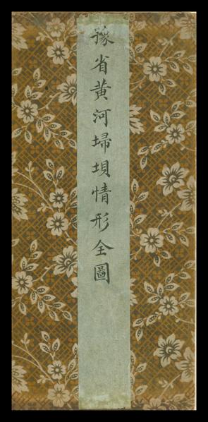
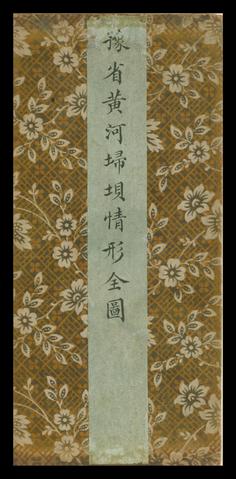
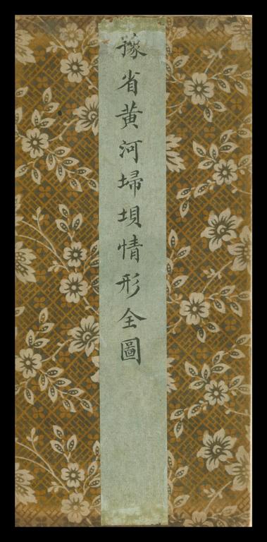
English: General Atlas Depicting the Conditions of the Yellow River Dykes in Henan Province
中文:豫省黃河埽埧局情形全图
Português: Atlas geral que representa as condições dos diques do Rio Amarelo na província de Henan
العربية: أطلس عام يصور أحوال حواجز النهر الأصفر بمقاطعة هينان
Español: Atlas general que muestra las condiciones de los diques del río Amarillo en la provincia de Henan |
| Description |
Русский: Этот созданный в эпоху династии Цин цветной атлас состоит из 21 сложенного гармошкой листа. Ориентация карт атласа прямо противоположна общепринятой, то есть юг находится вверху, север — внизу, запад — справа, а восток — слева. На картах показано расположение дамб вдоль Желтой реки на территории провинции Хэнань. Атлас начинается с расположенного на западе Хуаиньсяня, который граничит с провинциями Шэньси и Шаньси и тянется дальше на восток до Цаодань-Тина в провинции Шаньдун и Сяонань-Тина в Цзяннане. Подробно отмечены крепости, дамбы, а также численность солдат и строительных рабочих вдоль притоков Желтой реки. Эти данные показывают, как непросто было управлять рекой и какие страдания порой испытывали люди, жившие вдоль ее берегов. Слово "sao" в заголовке обозначает материал, использовавшийся в древности в проектах по сохранению рек, связанных с укреплением берегов и блокированием устьев. Этот материал представлял собой вязанки, состоявшие на 70 процентов из ивняка и на 30 процентов из соломы. Позже для этих целей также применялись стебли сорго. Подготовленные вязанки хранились для использования в чрезвычайных ситуациях. Кроме того, указанное слово употреблялось для обозначения различных типов рабочих в соответствии с их обязанностями. В некоторых случаях дамбы, сооруженные из этого материала, также назывались "sao". "Sao" подробно описывается в 11 цзюане работы по естествознанию под названием "Meng xi bi tan" ("Заметки, сделанные у Реки мечты"), автором которой является Шэнь Ко (1031–1095 гг.), живший в эпоху Сун.
Каналы; Борьба с наводнениями; Историческая география; Рукописные карты Français : Cet atlas de la dynastie Qing, peint en couleur, est formé de 21 feuilles pliées en accordéon. Les points cardinaux utilisés sur les cartes sont inversés par rapport à la pratique courante : le sud est placé en haut, le nord en bas, l'ouest à droite et l'est à gauche. Les cartes montrent la répartition des digues le long du fleuve Jaune sur les terres de la province du Henan. L'atlas commence par l'ouest avec Huayin Xian, qui borde les provinces du Shaanxi et du Shanxi, et continue vers l'est jusqu'à Caodan Ting dans la province du Shandong et Xiaonan Ting dans le Jiangnan. Les forteresses, les barrages, et le nombre de soldats et d'ouvriers de barrage sur les affluents du fleuve Jaune sont répertoriés en détail. Les descriptions attestent de la difficulté à réguler le débit du fleuve et des souffrances qu'il infligeait de temps à autre aux populations vivant sur ses rives. Sao, dans le titre, désigne une sorte de matériau qui servait à protéger les berges et bloquer les embouchures dans les projets de conservation des fleuves dans l'antiquité. Il était constitué de 70 % de saule et de 30 % de paille, ficelés en paquet. Plus tard, les paquets furent aussi formés à partir de tiges de sorgho. Ils étaient stockés, puis utilisés dans les situations d'urgence. Ce terme fut également employé pour nommer les différents types d'ouvrier en fonction de leur tâche. Parfois, les digues construites avec ces matériaux étaient également appelées sao. Le mot sao fut longuement abordé dans le onzième juan de Mengxi bitan (Discussions de pinceau depuis un petit ruisseau de rêve), ouvrage de sciences naturelles de l'auteur Song Shen Kuo (1031–1095).
Canaux; Contrôle des crues; Géographie historique; Cartes manuscrites English: This Qing-dynasty atlas painted in color is formatted in accordion pleat-like leaves, in 21 folded sheets. The directions used in the maps are the exact opposite of those commonly used, that is, the south is on the top, the north at the bottom, the west is on the right side, and the east on the left. The maps illustrate the distribution of dykes along the Yellow River within the territory of Henan Province. The atlas starts from the west with Huayin Xian, which borders Shaanxi and Shanxi provinces, and continues eastward to Caodan Ting in Shandong Province and Xiaonan Ting in Jiangnan. The fortresses, dams, and numbers of soldiers and dam laborers along the tributaries of the Yellow River are listed in detail. The descriptions attest to the difficulty of regulating the river and the degree of distress that it sometimes imposed on the people living near its banks. The word sao in the title denotes a kind of material used in ancient times in river conservancy projects to protect the riverbanks and to block the mouths of rivers. It was made of 70 percent willow and 30 percent straw, tied together into bundles. Later, stalks of sorghum were also used. The bundles were stored for use in emergency. The word was also applied to name different kinds of laborers according to their tasks. Sometimes dykes made with such material were also called sao. Sao was discussed in detail in juan 11 of Meng xi bi tan (Jottings written by the Dream Stream), a work on natural science written by the Song author Shen Kuo (1031–95).
Canals; Flood control; Historical geography; Manuscript maps 中文:此清代彩色地图为经摺裝,凡共21摺。所绘地图方位与一般常见地图方位相反,上方为南,下方为北,右方为西,左方为东。此图描绘河南省境內黃河橫亙全境经沿岸埽埧分布的情形。全图西起陕西华阴县界与山西交界,东至山东曹单厅和江南萧南厅。沿着黃河各支流边上的各堡、各汛大堤之长短、河兵堡夫的人数,均一一注明,甚是详尽。也可見治河的困难,以及黃河给沿岸中国居民造成的困忧。标题中所提「埽」字是指古代治河工程中用以护岸及堵口的材料。旧时多以柳七、草三捆紮而成,后代也多用秫稭 (高梁的莖秆)。捆紮成的「埽」则预储以为抢险之用。此字也用于指名各类治水河工, 有丁埽、顺埽等。犹言橫置、直置。凡用埽料修成的堤埧也叫埽。宋代作者沈括在他著名的自然科学著作《梦溪笔谈》第十一卷中也提及此种材料。
运河; 防洪; 历史地理学; 手绘地图 Português: Esse atlas colorido da dinastia Qing tem folhas sanfonadas em formato de prega, com 21 folhas dobradas. As direções usadas no mapa são o oposto exato das que costumam ser usadas, ou seja: o sul está no topo; o norte, na parte inferior; o oeste, do lado direito; e o leste, do lado esquerdo. Os mapas ilustram a distribuição de diques ao longo do Rio Amarelo dentro do território da província de Henan. O atlas começa pelo oeste com o Huayin Xian, que faz fronteira com as províncias de Shaanxi e Shanxi, e prossegue ao leste até Caodan Ting, província de Shandong, e Xiaonan Ting, Jiangnan. Os fortes, barragens e números de soldados e trabalhadores das barragens ao longo dos tributários do Rio Amarelo estão listados em detalhes. As descrições revelam a dificuldade de controlar o rio e o grau de sofrimento que ele por vezes impingia sobre a população que habitava suas margens. A palavra sao do título denota um tipo de material usado nos tempos antigos em projetos de conservação de rios para proteger as margens e bloquear as desembocaduras. Ele era composto por 70% de ramos de salgueiro e 30% de palha amarrados em feixes. Mais tarde, caules de sorgo também passaram a ser usados. Os feixes eram armazenados para o uso em emergências. A palavra também era usada para nomear diferentes tipos de trabalhadores de acordo com suas tarefas. Às vezes, os diques feitos desse material também eram chamados de sao. O sao foi discutido em detalhes no juan 11 do Meng xi bi tan (Notas escritas pelo fluxo dos sonhos), uma obra sobre ciência natural escrita por Shen Kuo (1031 a 1095), autor do período Song.
Canais; Controle de enchentes; Geografia histórica; Mapas manuscritos العربية: هذا الأطلس الملون الذي يرجع إلى عهد أسرة تشينغ مطبوع على صفحات مطوية على شاكلة الأكورديون، في 21 صحيفة مطوية. الاتجاهات المُستخدمة في الخرائط هي تماماً عكس تلك شائعة الاستخدام، أي أن الجنوب بالأعلى والشمال بالأسفل والغرب على الجانب الأيمن والشرق على الجانب الأيسر. توضح الخرائط توزيع الحواجز عبر النهر الأصفر بأراضي مقاطعة هينان. يبدأ الأطلس من الغرب بهواين تشيَن، الواقعة بين مقاطعتي شانشي وشنشي، ويستمر إلى الشرق إلى كودان تينغ بمقاطعة شاندونغ وتشياونان تينغ في جيانغنان. الحصون والسدود وأعداد الجنود وعمال السدود الذين يعملون على طول روافد النهر الأصفر موضَّحة بالتفصيل. تؤكد الأوصاف صعوبة التحكم في النهر ودرجة القلق التي كانت تساور الناس الذين يعيشون على ضفتيه في بعض الأحيان. تشير كلمة ساو المذكورة بالعنوان إلى نوع من المواد المُستخدمة في العصور القديمة في مشروعات صيانة الأنهار التي كانت تهدف إلى حماية الضفاف وسد مصبّات الأنهار. كانت الساو تُصنَّع من 70% من الصفصاف و30% من القش تُربَط معاً في حِزَم. فيما بعد استُخدمت سيقان الذرة. كانت الحزم تُخزَّن للاستخدام في حالات الطوارئ. كانت تُستخدم الكلمة كذلك في تسمية أنواع مختلفة من العمال كل حسب مهمته. في بعض الأحيان كان يطلق على الحواجز التي تُصنع من تلك المواد ساو. تم تناول مصطلح ساو في الباب 11من مينغ شي بي تان (ملاحظات سريعة كتبها مَجرى الحُلم)، وهو عمل حول العلوم الطبيعية بقلم مؤلف أسرة سونغ شين كو (1031-1095).
القنوات; السيطرة على الفيضان; الجغرافيا التاريخية; الخرائط المخطوطة Español: Este atlas de la dinastía Qing, pintado a color, consta de 21 hojas dobladas, encuadernadas en forma de acordeón. Los puntos cardinales utilizados en los mapas están indicados de forma exactamente opuesta a la práctica habitual: el Sur, en la parte superior; el Norte, en la inferior; el Oeste, a la derecha; y el Este, a la izquierda. Los mapas muestran la distribución de los diques a lo largo del río Amarillo, en el territorio de la provincia de Henan. El atlas comienza desde el oeste con Huayin Xian, en la frontera de las provincias de Shaanxi y Shanxi, y continúa hacia el este hasta Caodan Ting, en la provincia de Shandong, y Xiaonan Ting, en Jiangnan. Se enumeran en detalle las fortalezas, presas y la cantidad de soldados y obreros apostados a lo largo de los afluentes del río Amarillo. Las descripciones dan fe de la dificultad de regular el río y del grado de trastorno ocasionado, a veces, a quienes viven cerca de sus orillas. La palabra sao en el título denota un tipo de material utilizado en la antigüedad para proyectos de conservación de los ríos: se buscaba proteger las riberas y bloquear las desembocaduras. Estaba hecho 70 por ciento de sauce y 30 por ciento de paja, atados juntos en manojos. Luego, también se utilizaron tallos de sorgo. Los manojos se almacenaban para usar en situaciones de emergencia. La palabra también se aplicaba para nombrar a diferentes tipos de trabajadores en función de sus tareas. A veces, los diques hechos con este tipo de material también se llamaban sao. El juan 11 de Meng xi bi tan (Apuntes escritos por la corriente del sueño), una obra sobre ciencia natural escrita por Shen Kuo (1031-1095), escritor durante la dinastía Song, trata en detalle el tema del sao.
Canales; Control de inundaciones; Geografía histórica; Mapas manuscritos |
| Date | between 1644 and 1911 |
| Medium |
Русский: Книги
Français : Livres
English: Books
中文:图书
Português: Livros
العربية: كتب
Español: Libros |
| Dimensions |
English: 1 folded volume ; 22.6 x 10.7 centimeters |
| Collection |
Русский: Национальная центральная библиотека
Français : Bibliothèque centrale nationale
English: National Central Library
中文:国立中央图书馆
Português: Biblioteca Nacional Central
العربية: المكتبة المركزية الوطنية
Español: Biblioteca Nacional Central |
| Place of creation |
Русский: Провинция Хэнань
Français : Province du Henan
English: Henan Province
中文:河南省
Português: Província de Henan
العربية: مقاطعة خينان
Español: Provincia de Henan |
| Notes | Original language title: 豫省黃河埽埧情形全圖 |
| Source/Photographer |
http://dl.wdl.org/11390/service/11390.pdf
|
Licensing[edit]
|
This is a faithful photographic reproduction of a two-dimensional, public domain work of art. The work of art itself is in the public domain for the following reason:
The official position taken by the Wikimedia Foundation is that "faithful reproductions of two-dimensional public domain works of art are public domain".
This photographic reproduction is therefore also considered to be in the public domain in the United States. In other jurisdictions, re-use of this content may be restricted; see Reuse of PD-Art photographs for details. | ||||
File history
Click on a date/time to view the file as it appeared at that time.
| Date/Time | Thumbnail | Dimensions | User | Comment | |
|---|---|---|---|---|---|
| current | 09:41, 1 March 2014 |  | 1,233 × 2,500, 14 pages (2.6 MB) | Fæ (talk | contribs) | =={{int:filedesc}}== {{Artwork |artist = |author = |title ={{ru|1=Общий атлас, отражающий состояние дамб на Желтой реке в провинции Хэнань}} {{fr|1=Atlas général sur les conditions des digu... |
You cannot overwrite this file.
File usage on Commons
The following page uses this file: