File:Earth from Space- A veil of haze and smoke ESA25954650.tiff

Original file (4,627 × 5,524 pixels, file size: 185.61 MB, MIME type: image/tiff)
Captions
Captions
Summary[edit]
| Warning | The original file is very high-resolution. It might not load properly or could cause your browser to freeze when opened at full size. |
|---|
| Description |
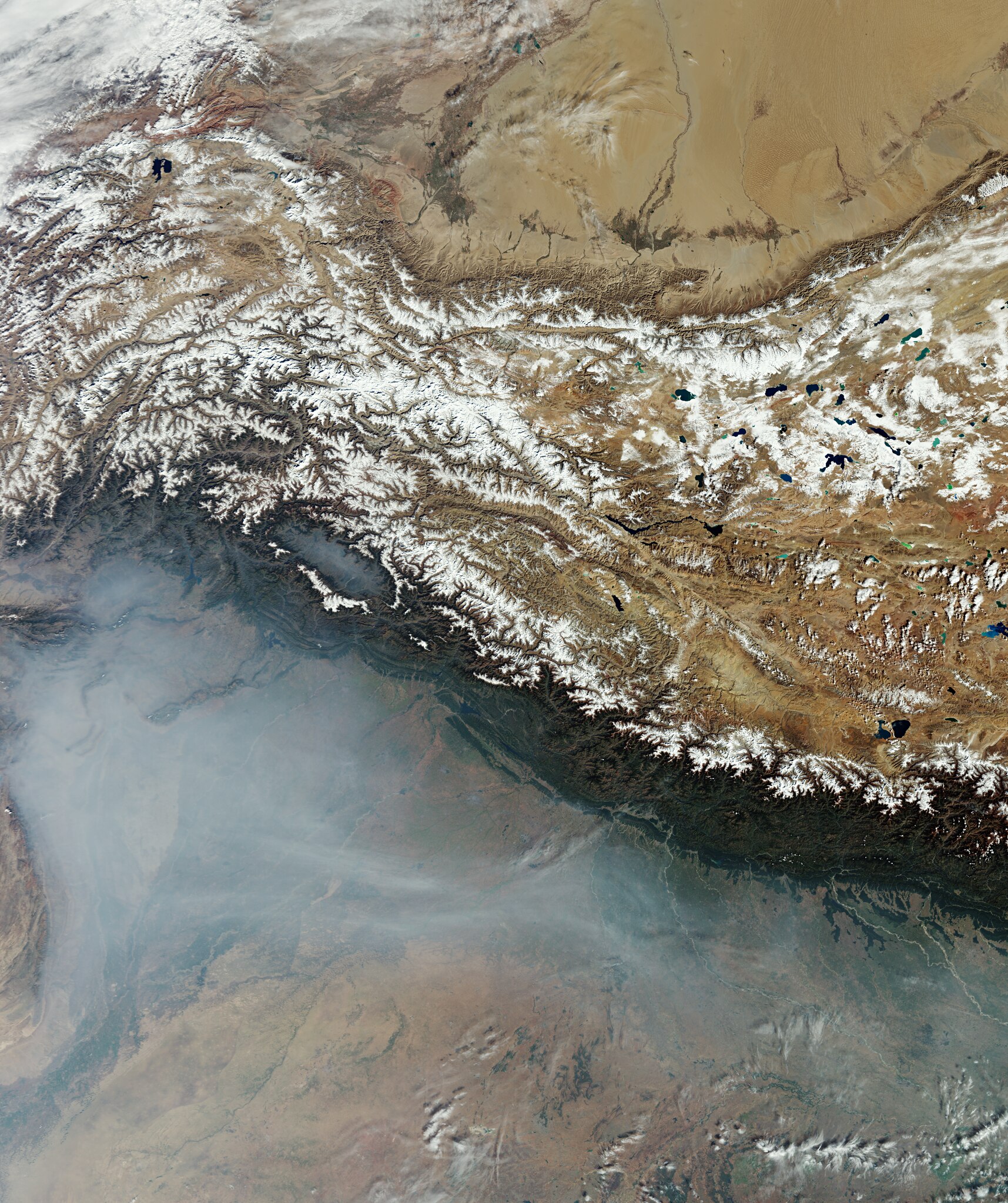
English: This Copernicus Sentinel-3 image from October 2023 captures the plains of northern India and Pakistan under a white veil of haze and smoke. Zoom in to explore this image at its full resolution or click on the circles to learn more. Most of the plains at the foothills of the Himalayas can be seen in the lower part of the image covered by thick haze and smoke. The haze is due to plains being more humid than the mountainous areas, which dominate the upper part of the image. Smoke adds significantly to the white veil and is a result of paddy stubble burning. Particularly common in the Indian regions of Punjab and Haryana, this practice involves burning the remains of crops at the end of the season to prepare for the following growing season. This image was acquired in October and the smoke here is a result of burning off the rice stubble at the end of their growing season. The snow-covered peaks of the Hindu Kush are in the top left of the image and the Karakoram range is to the east. North of the Himalayas, part of the Tibetan Plateau can be seen dotted with a number of lakes – many of which freeze for many months of the year. With an average height of over 4500 m, the Tibetan Plateau is the highest plateau on Earth. It is also the largest plateau on Earth covering an area four times the size of France. Owing to the variation in altitude and vegetation between the Tibetan Plateau and the plains of India and Pakistan, there is a distinct colour difference between the upper and lower part of the image. |
| Date | 23 February 2024 (upload date) |
| Source | Earth from Space: A veil of haze and smoke |
| Author | European Space Agency |
| Other versions |
|
| Activity | Observing the Earth |
| Mission | Sentinel-3 |
| Set | Earth from Space image collection |
| System | Copernicus |

Licensing[edit]

|
This image contains data from a satellite in the Copernicus Programme, such as Sentinel-1, Sentinel-2 or Sentinel-3. Attribution is required when using this image.
Attribution: Contains modified Copernicus Sentinel data 2023
The use of Copernicus Sentinel Data is regulated under EU law (Commission Delegated Regulation (EU) No 1159/2013 and Regulation (EU) No 377/2014). Relevant excerpts:
Free access shall be given to GMES dedicated data [...] made available through GMES dissemination platforms [...].
Access to GMES dedicated data [...] shall be given for the purpose of the following use in so far as it is lawful:
GMES dedicated data [...] may be used worldwide without limitations in time.
GMES dedicated data and GMES service information are provided to users without any express or implied warranty, including as regards quality and suitability for any purpose. |
This media was created by the European Space Agency (ESA).
Where expressly so stated, images or videos are covered by the Creative Commons Attribution-ShareAlike 3.0 IGO (CC BY-SA 3.0 IGO) licence, ESA being an Intergovernmental Organisation (IGO), as defined by the CC BY-SA 3.0 IGO licence. The user is allowed under the terms and conditions of the CC BY-SA 3.0 IGO license to Reproduce, Distribute and Publicly Perform the ESA images and videos released under CC BY-SA 3.0 IGO licence and the Adaptations thereof, without further explicit permission being necessary, for as long as the user complies with the conditions and restrictions set forth in the CC BY-SA 3.0 IGO licence, these including that:
See the ESA Creative Commons copyright notice for complete information, and this article for additional details.
|
 | |
This file is licensed under the Creative Commons Attribution-ShareAlike 3.0 IGO license. Attribution: ESA, CC BY-SA IGO 3.0
| ||
File history
Click on a date/time to view the file as it appeared at that time.
| Date/Time | Thumbnail | Dimensions | User | Comment | |
|---|---|---|---|---|---|
| current | 00:23, 28 March 2024 |  | 4,627 × 5,524 (185.61 MB) | OptimusPrimeBot (talk | contribs) | #Spacemedia - Upload of https://esamultimedia.esa.int/img/2024/02/Himalayas_S3_20231031_crop_ML.tif via Commons:Spacemedia |
You cannot overwrite this file.
File usage on Commons
The following page uses this file: