Category:SVG maps of Washington (state)
Jump to navigation
Jump to search
States of the United States: Alabama · Alaska · Arizona · Arkansas · California · Colorado · Connecticut · Delaware · Florida · Georgia · Hawaii · Idaho · Illinois · Indiana · Iowa · Kansas · Kentucky · Louisiana · Maine · Maryland · Massachusetts · Michigan · Minnesota · Mississippi · Missouri · Montana · Nebraska · Nevada · New Hampshire · New Jersey · New Mexico · New York · North Carolina · North Dakota · Ohio · Oklahoma · Oregon · Pennsylvania · Rhode Island · South Carolina · South Dakota · Tennessee · Texas · Utah · Vermont · Virginia · Washington · West Virginia · Wisconsin · Wyoming – Washington, D.C.
American Samoa · Guam · Northern Mariana Islands · Puerto Rico – Navassa Island · Palmyra Atoll
American Samoa · Guam · Northern Mariana Islands · Puerto Rico – Navassa Island · Palmyra Atoll
A collection of maps of Washington or portions thereof in SVG format.
Subcategories
This category has only the following subcategory.
Media in category "SVG maps of Washington (state)"
The following 66 files are in this category, out of 66 total.
-
 113th U.S. House districts in Washington.svg 369 × 242; 234 KB
-
 Blakely Island locator map.svg 1,052 × 744; 232 KB
-
 Blank Washington Map.svg 1,781 × 1,159; 231 KB
-
 Central Washington.svg 1,781 × 1,159; 227 KB
-
 US West Coast.svg 286 × 186; 137 KB
-
 Columbia gorge topographic map-fr.svg 682 × 359; 2.84 MB
-
 Condit Hydroelectric Project.svg 650 × 1,750; 65 KB
-
 Copalis NWR Map.svg 550 × 624; 283 KB
-
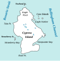
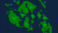
 Cypress Island locator map.svg 1,052 × 744; 232 KB
-
 Cypress Island Map.svg 393 × 401; 22 KB
-
 Decatur Island locator map.svg 1,052 × 744; 232 KB
-
 Eastern Washington map.svg 1,781 × 1,159; 220 KB
-
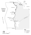 Flattery Rocks NWR Map.svg 550 × 630; 591 KB
-
 Guemes Island locator map.svg 1,052 × 744; 232 KB
-
 I-90 Seattle terminus.svg 640 × 320; 36 KB
-
 I-90 WA-1.svg 800 × 800; 94 KB
-
 Initiative 692 Results with Data.svg 1,781 × 1,159; 267 KB
-
 Initiative 692 Results.svg 1,781 × 1,159; 228 KB
-
 Inland Northwest United States.svg 280 × 280; 383 KB
-
 Inland Northwest.svg 991 × 1,056; 464 KB
-
 KSEA airport diagram.svg 484 × 743; 1,009 KB
-
 LGBT flag map of Washington.svg 5,920 × 3,856; 96 KB
-
 Lopez Island locator map.svg 1,052 × 744; 232 KB
-
 Lummi Island locator map.svg 1,052 × 744; 232 KB
-
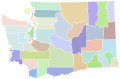
 Map of cities in Washington (state).svg 837 × 583; 2.74 MB
-
 Map of Liberty.svg 1,781 × 1,159; 231 KB
-
 Map of Washington counties, blank.svg 1,781 × 1,159; 215 KB
-
 Mount Adams Hazard map-fr.svg 760 × 873; 3.05 MB
-
 Mount Adams Region topographic map-fr 2.svg 513 × 669; 3.03 MB
-
 Mount Adams Region topographic map-fr.svg 751 × 870; 3.02 MB
-
 Mount Rainier National Park.svg 1,000 × 1,000; 35 KB
-
 Orcas Island locator map.svg 1,052 × 744; 232 KB
-
 Quillayute Needles NWR Map.svg 575 × 625; 647 KB
-
 Referendum 71 Results.svg 1,781 × 1,159; 228 KB
-
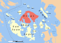
 San Juan Island locator map.svg 1,052 × 744; 232 KB
-
 San Juan Islands Locator Base.svg 562 × 405; 987 KB
-
 San-Juan-Islands-with-Grid.svg 512 × 288; 209 KB
-
 Seattle WA Directional Zones.svg 482 × 828; 28 KB
-
 Shaw Island locator map.svg 1,052 × 744; 232 KB
-
 South Washington Cascade Range topographic map-fr.svg 720 × 722; 6.86 MB
-
 South Washington protected areas map-fr.svg 720 × 722; 6.86 MB
-
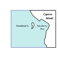 Strawberryis map.svg 393 × 401; 8 KB
-
 Sucia Island Map.svg 864 × 648; 9.18 MB
-
 Superfund sites in Washington.svg 634 × 420; 373 KB
-
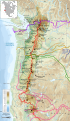
 Trails of Cascade Range map-fr.svg 403 × 693; 3.3 MB
-
 Trails of Cascade Range map-it.svg 403 × 693; 2.65 MB
-
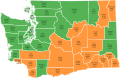
 United States House of Representatives Election 2016 - Washington.svg 1,000 × 763; 114 KB
-
 Wa 502.svg 1,781 × 1,159; 267 KB
-
 Washington administrative map-fr.svg 1,031 × 675; 4.06 MB
-
 Washington areas Columbia map-fr.svg 1,031 × 675; 7.04 MB
-
 Washington areas map-fr.svg 1,031 × 675; 7.06 MB
-
 Washington county map, cb 500k.svg 810 × 535; 57 KB
-
 Washington Court of Appeals divisions.svg 1,781 × 1,159; 235 KB
-
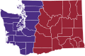
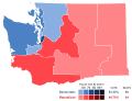
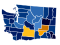
 Washington gubernatorial election, 2012 Map.svg 1,781 × 1,159; 228 KB
-
 Washington Initiative 502 Results.svg 166 × 124; 27 KB
-
 Washington Köppen.svg 1,260 × 1,242; 1.08 MB
-
 Washington municipal corporation topographic map-fr.svg 596 × 389; 7.43 MB
-
 Washington racial and ethnic map.svg 166 × 124; 17 KB
-
 Washington regions map.svg 1,781 × 1,159; 2.44 MB
-
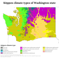
 Washington State Köppen Climate Types (1991-2020).svg 1,344 × 1,325; 1.32 MB
-
 Washington topographic map-fr.svg 1,031 × 675; 6.52 MB
-
 Washington tribal territories map-fr.svg 1,031 × 675; 6.3 MB
-
 Washington-state-map h.svg 709 × 470; 32 KB
-
 Western Washington map.svg 1,781 × 1,159; 215 KB
-
 WIAA Districts.svg 1,781 × 1,159; 237 KB
-
 Zip's Drive-in Locations.svg 1,921 × 1,477; 87 KB


.svg)


.svg)


