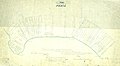
Category:Percé. This sketch show how the lands west of A & east of B are occupied.
& the claimants under the 10' & 11'. wel : chap. 30. desire to furnish this survey. in elucidation of their claims. and which Mr. Blakelack's survey. represents differently. as to lines. See K. D. Dumenesof. for example. & lots 14. again at Red head. H. to N. the lines of fence are even. N. 4" to 6oE. instead of. N 12oW or 15.o as Mr B___ has planned the lots.
Another error 25 in supposing I. Mann's adjudication at 7. or rear of Cape Cove lots. This is evident from identification and lot 6 being wounded on the East by lot 7. See the adjudicated claim to establish this fact.
Traduction :
Percé. Cette esquisse montre comment les terres à l'ouest de A et à l'est de B sont occupées.
et les demandeurs sous les 10' et 11' : chapitre 30 désirent fournir cet arpentage pour élucider leurs revendications et que l'arpentage de M. Blakelack représente différemment quant aux lignes. Voir K. D. Dumenesof. par exemple. & lots 14. à nouveau à Cap Rouge. De H. à N. les lignes de clôture sont égales. N. 4 à 6o E. au lieu de. N 12o O ou 15o comme M. B___ a planifié les lots.
Une autre erreur 25 en supposant le jugement de I. Mann à 7. ou derrière les lots de Cap d'Espoir. Cela ressort clairement de l'identification et du fait que le lot 6 a été blessé à l'est par le lot 7. Voir la demande jugée pour établir ce fait.
Media in category "Percé. This sketch show how the lands west of A & east of B are occupied."
The following 4 files are in this category, out of 4 total.
-
 Canton Perce, lots du rang I - 1849 - Centre.jpg 2,480 × 2,136; 1.14 MB
-
 Canton Perce, lots du rang I - 1849 - Est.jpg 3,256 × 3,408; 2.73 MB
-
 Canton Perce, lots du rang I - 1849 - Ouest.jpg 2,840 × 3,400; 2.35 MB
-
 Canton Perce, lots du rang I - 1849.jpg 7,887 × 4,311; 3.98 MB


