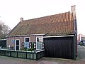
Category:Muntsjestege 10, Wierum
Jump to navigation
Jump to search
| Object location | | View all coordinates using: OpenStreetMap |
|---|
building in Dongeradeel, Netherlands  | |||||
| Upload media | |||||
| Instance of | |||||
|---|---|---|---|---|---|
| Location | Wierum, Noardeast-Fryslân, Friesland, Netherlands | ||||
| Street address |
| ||||
| Heritage designation |
| ||||
 | |||||
tegenover Tsjerkeplein 2
|
This is a category about rijksmonument number 42171
|
tegenover Muntsjestege 1
|
This is a category about rijksmonument number 38738
|
| Address |
|
Media in category "Muntsjestege 10, Wierum"
The following 7 files are in this category, out of 7 total.
-
 116, voorgevel - Wierum - 20255825 - RCE.jpg 1,200 × 802; 195 KB
-
 A.64, aanzicht - Wierum - 20255819 - RCE.jpg 1,200 × 802; 183 KB
-
 A.64, west-gevel - Wierum - 20255820 - RCE.jpg 803 × 1,200; 182 KB
-
 Muntjestege10 Wierum.jpg 1,824 × 1,368; 508 KB
-
 Wierum (Noardeast-Fryslân), 10-07-2023. (actm.) 22.jpg 4,286 × 3,215; 12.75 MB
-
 Wierum (Noardeast-Fryslân), 10-07-2023. (actm.) 23.jpg 4,574 × 3,267; 8.7 MB
-
 Wierum (Noardeast-Fryslân), 10-07-2023. (actm.) 24.jpg 3,179 × 4,768; 12.38 MB


,_10-07-2023._(actm.)_22.jpg)
,_10-07-2023._(actm.)_23.jpg)
,_10-07-2023._(actm.)_24.jpg)