Category:Maps of Corfu
Jump to navigation
Jump to search
Wikimedia category | |||||
| Upload media | |||||
| Instance of | |||||
|---|---|---|---|---|---|
| Category combines topics | |||||
| Corfu | |||||
Greek island in the Ionian Sea  La fortalesa i la ciutat velles de l'illa de Corfú  | |||||
| Instance of | |||||
| Part of | |||||
| Patron saint | |||||
| Location | Corfu Regional Unit, Ionian Islands Region, Decentralized Administration of Peloponnese, Western Greece and the Ionian Islands, Greece | ||||
| Located in or next to body of water | |||||
| Capital | |||||
| Significant event | |||||
| Width |
| ||||
| Length |
| ||||
| Highest point |
| ||||
| Population |
| ||||
| Area |
| ||||
| Different from | |||||
| official website | |||||
 | |||||
Subcategories
This category has the following 5 subcategories, out of 5 total.
Media in category "Maps of Corfu"
The following 44 files are in this category, out of 44 total.
-
 De Stad en Kasteel van Korfu - Dapper Olfert - 1688.jpg 1,500 × 1,198; 1.22 MB
-
 Plan de la place de Corfù avec ses environs assiegee par... - CBT 5883767.jpg 5,508 × 4,772; 8.93 MB
-
 Plan du siege de Corfù par terre et par mer avec... - CBT 5883740.jpg 5,508 × 4,772; 9.59 MB
-
 2010 Dimos Kerkyras.svg 2,127 × 2,349; 301 KB
-
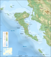
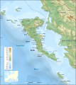
 Corfu Channel topographic map-en.svg 595 × 755; 2.23 MB
-
 Corfu Channel topographic map-fr.svg 595 × 755; 2.22 MB
-
 Corfu from ISS.jpg 767 × 1,643; 391 KB
-
 Corfu from ISS1.jpg 767 × 600; 105 KB
-
 Corfu in Greece.svg 1,003 × 825; 833 KB
-
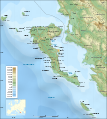
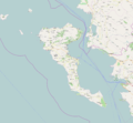
 Corfu OSM.png 1,386 × 1,186; 736 KB
-
 Corfu topographic map-be.svg 2,100 × 2,345; 2.43 MB
-
 Corfu topographic map-el.svg 2,100 × 2,345; 2.45 MB
-
 Corfu topographic map-eo.svg 2,100 × 2,345; 2.43 MB
-
 Corfu topographic map-hu.svg 2,100 × 2,345; 2.47 MB
-
 Corfu-ES.png 1,955 × 2,431; 1.26 MB
-
 Corfu-HE.png 1,955 × 2,431; 1.43 MB
-
 Corfú. Plano mudo.jpg 1,955 × 2,431; 831 KB
-
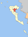
 Dimos Achillion.png 400 × 521; 27 KB
-
 Dimos Agiou Georgiou.png 400 × 521; 27 KB
-
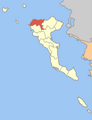 Dimos Esperion.png 400 × 521; 27 KB
-
 Dimos Feakon.png 400 × 521; 27 KB
-
 Dimos Kassiopeon.png 400 × 521; 27 KB
-
 Dimos Kerkyreon.png 400 × 521; 27 KB
-
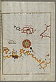
 France militaire 1836 TIII 157004.jpg 2,975 × 2,221; 1.15 MB
-
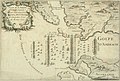 IAN 0212 d Anville 1734 Battle of Actium.jpg 5,136 × 3,459; 15.71 MB
-
 IAN 0944 Heather 1802 Corfu.jpg 4,639 × 3,759; 9.94 MB
-
 Karte Korfu.png 240 × 300; 107 KB
-
 Map of island Corfu.png 2,062 × 1,910; 1.07 MB
-
-
 Projector page for Corfu, screenshot.png 1,126 × 848; 442 KB
-
 Tischdecke in Makrades.JPG 800 × 1,200; 708 KB
-
 Corfu topographic map-blank.svg 2,100 × 2,345; 2.29 MB
-
 Corfu topographic map-de.svg 2,100 × 2,345; 2.43 MB
-
 Corfu topographic map-en librsvg.png 2,096 × 2,341; 2.1 MB
-
 Corfu topographic map-en rendersvg.png 2,096 × 2,341; 2.7 MB
-
 Corfu topographic map-en.svg 2,096 × 2,341; 2.19 MB
-
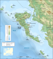 Corfu topographic map-es.svg 2,100 × 2,345; 2.49 MB
-
 Corfu topographic map-fr.svg 2,100 × 2,345; 2.46 MB
-
 Corfu topographic map-mk.svg 2,100 × 2,345; 2.45 MB
-
 Corfu topographic map-nb.svg 2,100 × 2,345; 2.46 MB
-
 Corfu topographic map-Stad.PNG 324 × 162; 51 KB
-
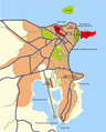
 Κέρκυρα - Πολεοδομικές Ενότητες - EN.png 809 × 676; 148 KB
-
 Κέρκυρα - Πολεοδομικές Ενότητες - ES.png 809 × 676; 152 KB
-
 Κέρκυρα - Πολεοδομικές Ενότητες.png 809 × 676; 148 KB


