Category:Le Moustier
Jump to navigation
Jump to search
Català: Lo Mostièr
· Deutsch: Le Moustier
· English: Le Moustier
· Español: Le Moustier
· Français : Le Moustier
· Polski: Le Moustier
·
|
This building is classé au titre des monuments historiques de la France. It is indexed in the base Mérimée, a database of architectural heritage maintained by the French Ministry of Culture, under the reference PA00082862
|
| Object location | | View all coordinates using: OpenStreetMap |
|---|
archaeological site  | |||||
| Upload media | |||||
| Instance of |
| ||||
|---|---|---|---|---|---|
| Part of | |||||
| Location | Saint-Léon-sur-Vézère, canton of Montignac | ||||
| Heritage designation |
| ||||
 | |||||
Media in category "Le Moustier"
The following 14 files are in this category, out of 14 total.
-
 1911 Britannica-Archaeology-Palaeolithic.png 692 × 821; 621 KB
-
 Alain Reverdit - Industrie lithique - Le Moustier (Dordogne).jpg 7,360 × 4,912; 12.71 MB
-
 Drawing of Neanderthal Man. Wellcome M0008959.jpg 2,785 × 3,882; 5.72 MB
-
 Flint, Moustier 1863.jpg 2,064 × 2,752; 1.11 MB
-
 Franks HouseDSCF7158.jpg 2,267 × 3,859; 2.55 MB
-
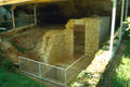
 Le Moustier cave shelter.jpg 800 × 944; 1.32 MB
-
 Le Moustier inf.jpg 800 × 531; 570 KB
-
 Le Moustier sup.jpg 800 × 1,239; 1.57 MB
-
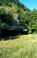
 Le Moustier.jpg 1,000 × 620; 425 KB
-
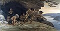 Neanderthal Flintworkers (Knight, 1920).jpg 1,137 × 586; 637 KB
-
 Paleolithic period.png 683 × 411; 590 KB
-
 Reliquiae aquitanicae--pl. A-03--BHL20495582.jpg 2,430 × 3,366; 681 KB
-
 Reliquiae aquitanicae--pl. A-17--BHL20495702.jpg 2,430 × 3,366; 772 KB
-
 Reliquiae aquitanicae--pl. A-25--BHL20495778.jpg 2,430 × 3,366; 834 KB

.jpg)


.jpg)


