Category:Hubertusbrunnen (Munich)
Jump to navigation
Jump to search
| Object location | | View all coordinates using: OpenStreetMap |
|---|
water well   | |||||
| Upload media | |||||
| Instance of | |||||
|---|---|---|---|---|---|
| Named after | |||||
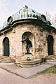
| Depicts | stag and Hubertus | ||||
| Location | |||||
| Street address |
| ||||
| Architect | |||||
| Heritage designation | |||||
| Inception |
| ||||
| Significant event |
| ||||
 | |||||
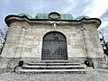
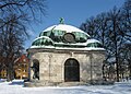
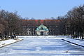
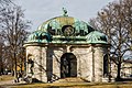
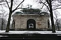
Deutsch: Der Hubertusbrunnen ist eine Brunnenanlage im Münchner Westen und befindet sich am östlichen Ende des Nymphenburger Kanals.
English: The Hubertusbrunnen is a well system in the west of Munich which is located at the eastern end of the Nymphenburger Kanal (Nymphenburg Channel).
Esperanto: Hubertusbrunnen estas puta instalaĵo en la okcidento de Munkeno (DE) kaj situas ĉe la orienta fino de la kanalo Nymphenburger Kanal.
This is the category of the Bavarian Baudenkmal (cultural heritage monument) with the ID D-1-62-000-7308 (Wikidata)
|
Media in category "Hubertusbrunnen (Munich)"
The following 54 files are in this category, out of 54 total.
-
 Adolf von Hildebrand - 'Jäger' vom Hubertusbrunnen in München.png 581 × 898; 1.11 MB
-
 Château de Numphenburg, depuis la Fontaine Hubertus (Munich).jpg 4,032 × 3,024; 2.68 MB
-
 Fontaine Hubertus (Munich) - depuis le canal.jpg 4,032 × 3,024; 5.09 MB
-
 Fontaine Hubertus (Munich) - Grille.jpg 3,024 × 4,032; 5.06 MB
-
 Fontaine Hubertus (Munich) - Statue 1.jpg 3,024 × 4,032; 6.4 MB
-
 Fontaine Hubertus (Munich) - Statue 2.jpg 3,024 × 4,032; 6.87 MB
-
 Fontaine Hubertus (Munich) - Statue 3.jpg 3,024 × 4,032; 7.07 MB
-
 Fontaine Hubertus (Munich) - Statue 4.jpg 3,024 × 4,032; 6.86 MB
-
 Fontaine Hubertus (Munich) - vue de côté.jpg 3,024 × 4,032; 5.08 MB
-
 Fontaine Hubertus (Munich) - vue depuis le bassin au bout du canal.jpg 4,032 × 3,024; 3.47 MB
-
 Hubertus Brunnen Muenchen,.jpg 2,732 × 1,534; 1.25 MB
-
 Hubertus Brunnen Muenchen.jpg 1,275 × 1,168; 247 KB
-
 Hubertusbrunnen Gitter.JPG 3,888 × 2,592; 3.18 MB
-
 Hubertusbrunnen Hirsch.JPG 3,888 × 2,592; 3.11 MB
-
 Hubertusbrunnen Innen.JPG 3,216 × 2,144; 2.93 MB
-
 Hubertusbrunnen Muenchen-10.jpg 3,648 × 4,944; 4.18 MB
-
 Hubertusbrunnen Muenchen-11.jpg 5,472 × 3,648; 4.13 MB
-
 Hubertusbrunnen Muenchen-12.jpg 5,325 × 3,645; 4.45 MB
-
 Hubertusbrunnen Muenchen-3.jpg 2,450 × 1,750; 976 KB
-
 Hubertusbrunnen Muenchen-4.jpg 2,450 × 1,800; 1,008 KB
-
 Hubertusbrunnen Muenchen-5.jpg 2,511 × 1,824; 959 KB
-
 Hubertusbrunnen Muenchen-6.jpg 1,944 × 2,592; 996 KB
-
 Hubertusbrunnen Muenchen-7.jpg 1,845 × 2,547; 909 KB
-
 Hubertusbrunnen Muenchen-8.jpg 5,472 × 3,648; 5.04 MB
-
 Hubertusbrunnen Muenchen-9.jpg 5,472 × 3,648; 4.74 MB
-
 Hubertusbrunnen Muenchen.jpg 3,456 × 2,304; 1.93 MB
-
 Hubertusbrunnen München von Gerner Brücke.jpg 5,788 × 3,862; 8.21 MB
-
 Hubertusbrunnen, Munich, in March.JPG 4,767 × 3,178; 12.35 MB
-
 Hubertusbrunnen, Múnich, Alemania, 2013-05-10, DD 01.jpg 5,597 × 3,073; 6.46 MB
-
 Hubertusbrunnen, Múnich, Alemania02.jpg 3,708 × 2,526; 1.61 MB
-
 Hubertusbrunnen, Múnich, Alemania04.JPG 3,888 × 2,592; 1.36 MB
-
 Hubertusbrunnen, Múnich, Alemania06.JPG 3,789 × 2,526; 9.26 MB
-
 Hubertusbrunnen, Múnich, Alemania08.JPG 3,888 × 2,592; 3.17 MB
-
 Hubertusbrunnen, Múnich, Alemania09.JPG 3,888 × 2,592; 2.54 MB
-
 Hubertusbrunnen, Múnich, Alemania10.JPG 3,771 × 2,514; 8.31 MB
-
 Hubertusbrunnen, Múnich, Alemania11.JPG 3,436 × 2,291; 6.12 MB
-
 Hubertusbrunnen, Múnich, Alemania13.JPG 3,888 × 2,592; 3.68 MB
-
 Hubertusbrunnen, Múnich, Alemania15.jpg 2,472 × 3,736; 2.12 MB
-
 Hubertusbrunnen-1.jpg 900 × 1,200; 347 KB
-
 Hubertusbrunnen.JPG 3,216 × 2,144; 3.14 MB
-
 Lehel - Hubertusbrunnen - 20150101164136.jpg 3,832 × 2,623; 3.04 MB
-
 Lehel - Hubertusbrunnen - 20160517001448.jpg 4,208 × 2,858; 6.47 MB
-
 Muehubertusbrunnenno112018c90.jpg 7,360 × 4,907; 22.16 MB
-
 Muehubertusbrunnt0a2011.jpg 823 × 1,401; 325 KB
-
 Muenchen-Hubertusbrunnen-bjs-1.jpg 1,024 × 1,536; 535 KB
-
 Muenchen-Hubertusbrunnen-bjs-2.jpg 1,024 × 1,536; 435 KB
-
 München, Hubertusbrunnen von Westen, 7.jpeg 2,656 × 4,480; 4.01 MB
-
 München, Hubertusbrunnen von Westen, 9.jpeg 2,800 × 2,448; 1.89 MB
-
 München, Hubertusbrunnen, Kuppelfigur, 2.jpeg 2,000 × 2,440; 1.85 MB
-
 München-Neuhausen Hubertusbrunnen 658.jpg 4,896 × 3,264; 12.67 MB
-
 München-Neuhausen Hubertusbrunnen 663.jpg 3,174 × 4,761; 12.44 MB
-
 Nymphenburg Channel and Hubertusbrunnen in the background.jpg 4,000 × 3,000; 8.49 MB
-
 Nymphenburg Channel and the Hubertusbrunnen on the left.jpg 4,000 × 3,000; 13.43 MB
-
 Nymphenburg Channel2.jpg 4,000 × 3,000; 2.78 MB

.jpg)
_-_depuis_le_canal.jpg)
_-_Grille.jpg)
_-_Statue_1.jpg)
_-_Statue_2.jpg)
_-_Statue_3.jpg)
_-_Statue_4.jpg)
_-_vue_de_c%C3%B4t%C3%A9.jpg)
_-_vue_depuis_le_bassin_au_bout_du_canal.jpg)


