Category:Fairbrothers farmhouse, Newton-le-Willows
Jump to navigation
Jump to search
| Object location | | View all coordinates using: OpenStreetMap |
|---|
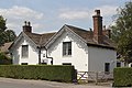
grade II listed farmhouse in Newton-le-Willows, St Helens, St. Helens, Merseyside, UK  | |||||
| Upload media | |||||
| Instance of | |||||
|---|---|---|---|---|---|
| Location | St Helens, Merseyside, North West England, England | ||||
| Heritage designation |
| ||||
 | |||||
Grade II listed farmhouse dating to 1692, per datestone on the front elevation.
Media in category "Fairbrothers farmhouse, Newton-le-Willows"
The following 4 files are in this category, out of 4 total.
-
 Datestone of Fairbrothers Farmhouse, Newton-le-Willows.jpg 3,408 × 2,875; 11.88 MB
-
 Fairbrothers Farmhouse, Newton-le-Willows 1.jpg 5,038 × 3,335; 20.44 MB
-
 Fairbrothers Farmhouse, Newton-le-Willows 2.jpg 4,984 × 3,312; 20.73 MB
-
 Fairbrothers Farmhouse, Newton-le-Willows 3.jpg 5,076 × 3,458; 23.93 MB


