Category:English-language maps of Europe
Jump to navigation
Jump to search
Subcategories
This category has the following 40 subcategories, out of 40 total.
*
A
- English-language maps of Albania (20 F)
B
C
- English-language maps of Croatia (13 F)
D
E
- English-language maps of Estonia (11 F)
F
G
H
I
K
L
M
- English-language maps of Moldova (12 F)
N
- English-language maps of Norway (13 F)
P
R
S
- English-language maps of Sweden (33 F)
T
U
Media in category "English-language maps of Europe"
The following 200 files are in this category, out of 221 total.
(previous page) (next page)-
 007 Ukrainian Cossack Hetmanate and Russian Empire 1751.jpg 767 × 952; 414 KB
-

-

-
 1794 Campbell Map of Scotland - Geographicus - Scotland-campbell-1794.jpg 5,032 × 6,000; 8.43 MB
-
-

-
 1794 D'Anville Two Panel Wall Map of Europe - Geographicus - Europe-anville-1794.jpg 7,000 × 6,110; 13.05 MB
-

-

-

-
-

-

-
-
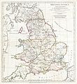
 1796 Cary Folding Case Map of England ^ Wales - Geographicus - EnglandWales-cary-1793.jpg 5,000 × 6,048; 7.78 MB
-

-
 1799 Cary Map of Mantua, Venice and Tyrol, Italy - Geographicus - Venice-cary-1799.jpg 5,000 × 4,513; 8.31 MB
-
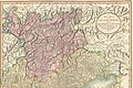
 1799 Cary Map of Piedmont, Italy ( Milan, Genoa ) - Geographicus - Piedmont-cary-1799.jpg 5,000 × 4,441; 8.17 MB
-
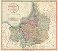
 1799 Cary Map of Poland, Prussia and Lithuania - Geographicus - Poland-cary-1799.jpg 5,000 × 4,416; 7.6 MB
-
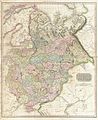
 1799 Cary Map of Prussia and Lithuania - Geographicus - Prussia-cary-1799.jpg 5,000 × 4,364; 6.48 MB
-
 1799 Cary Map of Tyrol - Geographicus - Venice-cary-1799.jpg 4,883 × 3,253; 15.16 MB
-

-
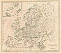 1799 Clement Cruttwell Map of Europe - Geographicus - Europe-cruttwell-1799.jpg 3,500 × 3,028; 2.92 MB
-
-

-
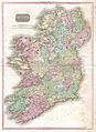
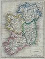
 1799 Clement Cruttwell Map of Ireland - Geographicus - Ireland-cruttwell-1799.jpg 2,962 × 3,500; 2.72 MB
-
 1799 Clement Cruttwell Map of Italy - Geographicus - Italy-cruttwell-1799.jpg 3,500 × 2,999; 2.69 MB
-
 1799 Clement Cruttwell Map of Scotland - Geographicus - Scotland-cruttwell-1799.jpg 3,062 × 3,500; 2.72 MB
-

-

-
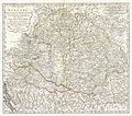
 1801 Cary Map of Austria - Geographicus - Austria-cary-1801.jpg 5,000 × 4,488; 7.86 MB
-
 1801 Cary Map of Scotland (4 Sheets) - Geographicus - Scotland-cary-1801.jpg 7,000 × 6,322; 13.91 MB
-
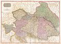
 1801 Cary Map of Westphalia, Germany - Geographicus - Westphalia-cary-1799.jpg 5,000 × 4,434; 7.5 MB
-

-
 1814 Thomson Map of Bavaria, Germany - Geographicus - Bavaria-t-1814.jpg 2,500 × 2,131; 1.34 MB
-
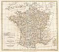
 1814 Thomson Map of France - Geographicus - France-t-1814.jpg 6,000 × 5,160; 9.18 MB
-

-
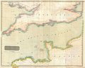 1814 Thomson Map of the English Channel - Geographicus - BritishChannel-thomson-1814.jpg 5,000 × 4,029; 4.94 MB
-
 1814 Thomson Map of Tuscany (Florence), Italy - Geographicus - Tuscany-t-1814.jpg 3,000 × 3,602; 2.76 MB
-
 1815 Thomson Map of Spain and Portugal - Geographicus - Spain-t-15.jpg 3,000 × 2,515; 2.05 MB
-
 1818 Pinkerton Map of Beligum - Geographicus - Belgium-pinkerton-1818.jpg 5,000 × 3,632; 4.97 MB
-
 1818 Pinkerton Map of Holland or the Netherlands - Geographicus - Holland-pinkerton-1818.jpg 5,000 × 4,457; 6.09 MB
-
 1818 Pinkerton Map of Ireland - Geographicus - Ireland-pinkerton-1818.jpg 3,645 × 5,000; 5.38 MB
-
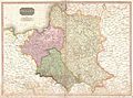 1818 Pinkerton Map of Poland - Geographicus - Poland-pinkerton-1818.jpg 5,000 × 3,691; 5.15 MB
-
 1818 Pinkerton Map of Russia in Europe - Geographicus - RussiaEurope-pinkerton-1818.jpg 4,090 × 5,000; 6.37 MB
-
 1818 Pinkerton Map of Spain and Portugal - Geographicus - SpainPortugal-pinkerton-1818.jpg 5,000 × 3,615; 5.25 MB
-
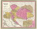
 1818 Pinkerton Map of the Austrian Empire - Geographicus - Austria-pinkerton-1818.jpg 5,000 × 3,642; 5.51 MB
-

-
 1822 Butler Map of Ireland - Geographicus - Ireland-butler-1822.jpg 2,317 × 3,032; 1.65 MB
-
 1830 Pigot Pocket Map of England and Wales - Geographicus - EnglandWales-pigot-1830.jpg 3,500 × 4,463; 5.15 MB
-
-
 1845 Chambers Map of Ancient Italy - Geographicus - ItalyAncient-chambers-1845.jpg 2,061 × 2,500; 1.38 MB
-
 1850 Mitchell - Cowperthwait Map of Denmark - Geographicus - Denmark-cowperthwait-1850.jpg 2,451 × 3,000; 2.23 MB
-
 1850 Mitchell and Cowperthwait Map of Ireland - Geographicus - Ireland-m-1850.jpg 2,416 × 3,000; 2.02 MB
-
-
 1850 Mitchell Map of Europe - Geographicus - Europe-mitchell-1850.jpg 3,500 × 2,788; 3.12 MB
-
 1850 Mitchell Map of Greece - Geographicus - Greece-m-50.jpg 3,000 × 2,444; 2.4 MB
-

-
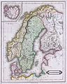
 1851 Black Map of Norway and Sweden (Scandinavia) - Geographicus - NorwaySweden-black-51.jpg 3,192 × 4,592; 2.43 MB
-
 1853 Mitchell Map of Austria - Geographicus - Austrai-mitchell-1853.jpg 3,000 × 2,385; 2.43 MB
-
 1853 Mitchell Map of Germany - Geographicus - Germany-mitchell-1850.jpg 2,389 × 3,000; 2.54 MB
-
 1862 Johnson Map of Spain and Portugal - Geographicus - SpainPortugal-j-62.jpg 3,000 × 2,404; 2.43 MB
-
 1899 satirical map of Europe - Angling in troubled waters - by Fred W. rose.tiff 9,704 × 7,238; 200.98 MB
-
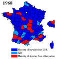 1968legifr.png 283 × 294; 11 KB
-
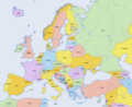
 2008 Europe Political Map EN.jpg 1,683 × 2,146; 878 KB
-
 4.7KentEngland4.28.07.jpg 517 × 665; 54 KB
-
 AEF Stations France 1918.jpg 1,500 × 1,640; 341 KB
-
 Alliances of europe.png 1,270 × 1,161; 134 KB
-

-
 Angling in Troubled Waters A Serio-Comic Map of Europe.jpg 7,557 × 5,452; 9.36 MB
-
 Angling in troubled waters – a serio-comic map of Europe - Kungliga Biblioteket - 2818247-thumb.png 12,010 × 9,183; 517.45 MB
-
-
 Au-map.png 400 × 429; 30 KB
-
 Austria states english.png 1,000 × 524; 24 KB
-
 Austria-Hungary (ethnic).JPG 5,150 × 3,395; 4.73 MB
-
 BAUDINO EUROPA 2.JPG 798 × 570; 68 KB
-
 BAZA EUROPA.JPG 797 × 551; 63 KB
-
 Angling in troubled waters- a serio-comic map of Europe. (IA bp 14539).pdf 743 × 1,095, 3 pages; 5.23 MB
-
 Bubonic plague map 2.png 1,000 × 1,048; 159 KB
-
 Caricature map 1914--1915--1916--1917--??.jpg 5,223 × 3,909; 5.5 MB
-
 Carolingian empire 863.pdf 1,650 × 1,275; 152 KB
-
 Carolingian empire 870.pdf 1,650 × 1,275; 143 KB
-
 Cassubia1238 Język Kaszubski 2002.png 4,315 × 2,590; 939 KB
-
 Cassubia1238 Kaszubi na Pomorzu.png 2,288 × 1,408; 460 KB
-
 Cassubia1238 Narodowość Kaszubska 2002.png 4,315 × 2,590; 901 KB
-
 Castile (PSF).jpg 304 × 205; 99 KB
-
 CATALAN COUNTRIES 2.PNG 953 × 1,080; 133 KB
-

-
 Central Europe (CIA).jpg 1,028 × 1,242; 247 KB
-
 Central europe 919 1125.png 2,281 × 1,801; 2.91 MB
-
 Central Europe.png 507 × 422; 54 KB
-
 Centre of Europe.jpg 4,040 × 3,592; 1.14 MB
-
 Climates of Italy.PNG 541 × 632; 25 KB
-
 Countries of Europe last subordination png.png 1,280 × 979; 366 KB
-
 Course Channeltunnel en.png 472 × 387; 21 KB
-
 Danube River Basin Boundaries - DPLA - 7faf360017077c7d8baba44e6cc73335.jpg 6,760 × 4,274; 3.77 MB
-
 Dialectal map of Catalan Language.png 1,014 × 1,368; 300 KB
-

-
 ECDM 20220930 DM CoronaVirusOutbreak EEAS Europa.pdf 1,754 × 1,239; 1.09 MB
-
 English conquests in france 1382.jpg 885 × 1,212; 402 KB
-
 Estimated Port Capacities in Europe as of 1943.jpg 7,044 × 5,800; 8.86 MB
-
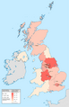 Ethnic Pakistanis in Britain.png 1,846 × 2,852; 825 KB
-
 Ethnographic Iberia 200 BCE.PNG 677 × 630; 59 KB
-
 EUgivetake2013.svg 600 × 768; 747 KB
-
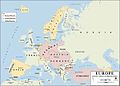 Europe 1914.jpg 1,198 × 863; 110 KB
-
 Europe countries map contours.png 1,475 × 1,200; 106 KB
-
 Europe countries map contours.xcf 1,475 × 1,200; 438 KB
-
 Europe countries map de contours no visa.png 1,475 × 1,200; 130 KB
-
 Europe countries map de contours no visa.xcf 1,475 × 1,200; 470 KB
-
 Europe countries map ee.png 498 × 398; 253 KB
-
 Europe countries map en 2.png 1,473 × 1,198; 456 KB
-
 Europe countries map en.png 1,475 × 1,200; 612 KB
-
 Europe Iron ore reserves - Departement of state, map division - btv1b53196975w.jpg 9,337 × 8,047; 6.34 MB
-
 Europe time zones map en.png 1,475 × 1,200; 981 KB
-
 Europe topography map en.png 1,473 × 1,198; 728 KB
-
 Europe, EU, candidates,.png 1,231 × 929; 63 KB
-
 Europe-large.png 1,242 × 1,371; 265 KB
-
 European countries by forest cover.jpg 3,891 × 3,160; 4.49 MB
-
 ExpansionofModernGreece.png 2,464 × 1,964; 503 KB
-
 France GHI Solar-resource-map GlobalSolarAtlas World-Bank-Esmap-Solargis.png 1,842 × 2,369; 1,018 KB
-
 Fred W Rose Angling in troubled waters.jpg 3,947 × 2,828; 2.97 MB
-

-
 Germanempire 1871 english plus language.jpg 468 × 319; 37 KB
-
 Germany general map.jpg 1,979 × 2,518; 3.95 MB
-
 Germany general map.png 1,979 × 2,518; 7 MB
-
 Germany topo.jpg 2,011 × 2,654; 2.55 MB
-
 Greecemap.gif 979 × 747; 76 KB
-
 Greek dialects.png 653 × 520; 352 KB
-
 Hu-map Modifiziert Route.png 635 × 325; 17 KB
-
 Iberia 300BC-pt.svg 924 × 762; 764 KB
-
 Iberia Late Bronze.gif 484 × 467; 17 KB
-
 Independent Television ITV regional map 1962-1964.png 2,200 × 2,200; 228 KB
-
 Independent Television ITV regional map 1964-1968.png 2,200 × 2,200; 220 KB
-
 Independent Television ITV regional map 1968-1974.png 2,200 × 2,200; 230 KB
-
 Irishin1871.jpg 793 × 967; 614 KB
-
 Italian Wine Regions.jpg 1,108 × 1,097; 167 KB
-
 John Cary 1799 map of the territory of Bergamo.jpg 740 × 1,353; 420 KB
-
 Karta hrvatska.jpg 419 × 447; 95 KB
-
 Kashubian language and nationality.png 2,858 × 1,825; 1.12 MB
-
 Kashubians in Poland with polstats big.png 2,726 × 2,558; 428 KB
-
 Kashubians in Poland.png 955 × 916; 95 KB
-
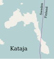 Kataja-en.svg 1,134 × 1,220; 31 KB
-
 Kattowitz map simple.jpg 2,007 × 1,927; 772 KB
-
 Kinks International Tour 1969 Detail.png 810 × 966; 874 KB
-
 Kinks International Tour 1969.jpg 394 × 427; 56 KB
-
 Kosovo uranium NATO bombing1999.png 730 × 805; 53 KB
-
 Krain ETHNIC 1910 Pict 1.JPG 208 × 232; 14 KB
-
 Languages and ethnic groups in austria3.png 682 × 351; 260 KB
-
 Life expectancy map -EU -2019 -with names.png 4,592 × 3,196; 1.14 MB
-
 Life expectancy map -EU -2020 -with names.png 4,592 × 3,196; 1.16 MB
-
 Life expectancy map -EU -2021 -with names.png 4,592 × 3,196; 1.16 MB
-
 Life expectancy map -Europe -2019 -with names.png 4,592 × 3,196; 1.07 MB
-
 Life expectancy map -Europe -2020 -with names.png 4,592 × 3,196; 1.07 MB
-
 Life expectancy map -Europe -2021 -with names.png 4,592 × 3,196; 1.08 MB
-
 Life expectancy map -Europe exp -2019 -with names.png 4,592 × 3,196; 1.06 MB
-
 Life expectancy map -Europe exp -2020 -with names.png 4,592 × 3,196; 1.06 MB
-
 Life expectancy map -Europe exp -2021 -with names.png 4,592 × 3,196; 1.07 MB
-
 Lithuanian (1850).jpg 1,386 × 1,021; 962 KB
-
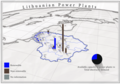 Lithuanian Power Plants.png 2,200 × 1,533; 5.24 MB
-
 Lux topo en.jpg 1,400 × 1,648; 851 KB
-
 Map of Europe (FL50811024 3718103).jpg 13,890 × 11,280; 234.96 MB
-
 Map of European states and nationalities in 1917.jpg 2,061 × 2,002; 1.56 MB
-
-
 Map of Sweden Cities (polar stereographic).png 999 × 2,387; 963 KB
-
 Map of the Energy Community Members.jpg 2,454 × 1,944; 400 KB
-

-
 Map- France at the Treaty of Bretigny (cropped).jpg 961 × 1,134; 302 KB
-
 Map- France at the Treaty of Bretigny.jpg 1,107 × 1,389; 384 KB
-
 Map-Battle of Suomussalmi-eng.png 800 × 926; 889 KB
-
 Median wealth per adult in Europe (2019).png 4,592 × 3,196; 1.01 MB
-
 MKD muni nonn Rural-Urban.png 500 × 392; 373 KB
-
 No-map.png 330 × 715; 37 KB
-
 North Sea flood of 1953.png 1,318 × 871; 248 KB
-

-
 Partition of Ottoman Empire (Anatolia).png 738 × 625; 29 KB
-
 Physico-Geographical Regionalization of Poland.png 2,000 × 1,700; 1.99 MB
-
 Poland 1569 map.jpg 812 × 641; 109 KB
-
 Poland 1634-1660 map.jpg 695 × 600; 84 KB
-
 Poland 1772 map.jpg 775 × 568; 117 KB
-
 Poland 1795 map.jpg 777 × 571; 146 KB
-
 Poland airports 2005.png 702 × 436; 104 KB
-
 Poland airports 2011plusUnderConstruction.png 1,690 × 1,569; 1.87 MB
-
 Poland airports 2012.png 1,021 × 948; 472 KB
-
 Poland topo.jpg 1,400 × 1,364; 756 KB
-
 Polandmap cia gdansk.png 246 × 400; 20 KB
-
 Polesia map - topography.jpg 740 × 542; 353 KB
-

-
 Pvgis solar horiz CZ.png 1,024 × 842; 637 KB
-
 Pvgis solar optimum CZ.png 1,024 × 842; 637 KB
-
 Regional vote IT 1970.png 1,632 × 2,112; 129 KB
-
 Saimaakanal-en.svg 622 × 1,107; 2.29 MB
-
 Samuel John Neele, Ancient Europe (FL33132557 2521729).jpg 6,564 × 5,352; 47.98 MB
-
 Sardinia Köppen.svg 765 × 1,584; 816 KB
-
 Savarivermap.png 287 × 287; 37 KB
-
 Scotland map-en.jpg 2,400 × 3,450; 2.17 MB
-
 Scotland topographic map-en.jpg 2,400 × 3,450; 2.29 MB
-
 ScotlandGaelicSpeakers2001.gif 448 × 679; 15 KB
-
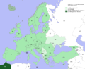
 Second world war europe 1943-1945 map en.png 1,090 × 1,000; 264 KB
-

-
 Serbia lsv.png 477 × 819; 43 KB

%27_(11268926146).jpg)


_-_Geographicus_-_Bavaria-cary-1799.jpg)

_-_Geographicus_-_Piedmont-cary-1799.jpg)


_-_Geographicus_-_Scotland-cary-1801.jpg)

_-_Geographicus_-_ItalyNorth-pinkerton-1809.jpg)


_and_the_Balkans_-_Geographicus_-_TurkeyEurope-t-1814.jpg)

,_Italy_-_Geographicus_-_Tuscany-t-1814.jpg)


_-_Geographicus_-_BritishIsles-pinkerton-1818.jpg)


_-_Geographicus_-_Scandinavia-lizar-1840.jpg)


_-_Geographicus_-_NorwaySweden-black-51.jpg)


.jpg)


.JPG)


.jpg)

.jpg)
.jpg)


.jpg)


.jpg)


.png)

_and_Levallois-Mousterian_(blue_circle)_sites_in_Europe_during_MIS_5c%E2%80%945a_and_Stajnia_Cave.webp)
.jpg)


.png)


.png)


.jpg)


