Category:Drakes Bay Historic and Archeological District
Jump to navigation
Jump to search
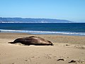
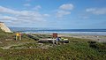
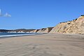
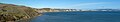
Drakes Bay Historic and Archeological District on the coast of northern California in the United States, considered the most likely west coast landing spot of Francis Drake on his 1579 circumnavigation of the world.
|
This is a category about a place or building that is listed on the National Register of Historic Places in the United States of America. Its reference number is 12001006. |
archeological site in Marin County, California  | |||||
| Upload media | |||||
| Instance of | |||||
|---|---|---|---|---|---|
| Named after |
| ||||
| Located in protected area | |||||
| Location | Marin County, California, Pacific States Region | ||||
| Heritage designation |
| ||||
 | |||||
Media in category "Drakes Bay Historic and Archeological District"
The following 30 files are in this category, out of 30 total.
-

-
 California - Drakes Bay - 20180217150000.jpg 4,000 × 3,003; 7.63 MB
-
 California - Drakes Bay - 20180217150004.jpg 4,000 × 3,004; 5.87 MB
-
 California - Drakes Bay - 20180217150102.jpg 4,000 × 3,003; 8.52 MB
-
 California - Drakes Bay - 20180217152110.jpg 3,300 × 2,478; 7.11 MB
-
 California - Drakes Bay - 20180217152145.jpg 4,000 × 3,003; 8.6 MB
-
 California - Drakes Bay - 20180217172514.jpg 3,300 × 2,477; 4.71 MB
-
 California - Drakes Bay - 20180217172538.jpg 4,000 × 3,004; 8.37 MB
-
 California - Drakes Bay - 20180217174651.jpg 4,000 × 3,003; 8.76 MB
-
 Drake's Bay From Above.jpg 2,730 × 4,095; 5.11 MB
-
 Drake's Beach at Drakes Bay.jpg 5,312 × 2,988; 1.75 MB
-
 Drake's Beach panorama.jpg 6,148 × 1,292; 2.17 MB
-
 Drakes Bay 20190315.JPG 5,472 × 3,648; 3.73 MB
-
 Drakes Bay Cliffs.JPG 2,592 × 1,936; 1.99 MB
-
 Drakes Bay Historic and Archaelogical Site.jpg 5,312 × 2,988; 3.19 MB
-
 Drakes Bay Seacliffs.JPG 2,592 × 1,936; 1.46 MB
-
 Drakes Bay.jpg 6,000 × 4,000; 13.1 MB
-
 Elk above Drake's Bay - Flickr - Gunn Shots.jpg 5,914 × 3,942; 3.27 MB
-
 High tide at Drakes Bay.jpg 1,024 × 768; 237 KB
-
 Long-billed curlew at Drakes Beach, Point Reyes.jpg 3,544 × 2,363; 3.8 MB
-

-
 Panorama of Drakes Bay 01.jpg 6,123 × 1,723; 1.35 MB
-
 Panorama of Drakes Bay 02.jpg 21,311 × 2,813; 9.87 MB
-
 Panorama of Drakes Bay 03.jpg 12,484 × 2,305; 3.86 MB
-
 Panorama of Drakes Bay 04.jpg 13,111 × 2,458; 4.02 MB
-
 Panorama of Drakes Bay 05.jpg 17,063 × 3,799; 5.68 MB
-
 Panorama of Drakes Bay 06.jpg 13,365 × 3,797; 3.59 MB
-
 Panorama of Drakes Bay 07.jpg 25,225 × 3,620; 8.09 MB
-
 Panorama of Drakes Bay 08.jpg 42,922 × 3,693; 11.39 MB
-
 View of Drakes Bay Historic and Archeological District from the South.JPG 3,872 × 2,592; 3.45 MB


