Category:Brücke Unterstetten (Scheideggstrasse, Rigi)
Jump to navigation
Jump to search
| Object location | | View all coordinates using: OpenStreetMap |
|---|
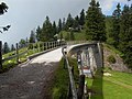
old railroad bridge of the Rigischeideggbahn in the municipality of Arth in the canton of Schwyz, Switzerland  | |||||
| Upload media | |||||
| Instance of | |||||
|---|---|---|---|---|---|
| Part of | |||||
| Location | Arth, Schwyz District, Schwyz, Switzerland | ||||
| Heritage designation | |||||
 | |||||
Media in category "Brücke Unterstetten (Scheideggstrasse, Rigi)"
This category contains only the following file.
-
 2009 08 12 Rigi - Voormalige Rigi-Scheidegg Bahn 4.JPG 2,240 × 1,680; 820 KB