Category:Albion Street Mews, Birkenhead
Jump to navigation
Jump to search
| Object location | | View all coordinates using: OpenStreetMap |
|---|
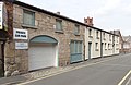
grade II listed former mews in BIrkenhead, Wirral, Merseyside, UK  | |||||
| Upload media | |||||
| Instance of | |||||
|---|---|---|---|---|---|
| Location | Wirral, Merseyside, North West England, England | ||||
| Heritage designation |
| ||||
 | |||||
Media in category "Albion Street Mews, Birkenhead"
The following 2 files are in this category, out of 2 total.
-
 Albion Street Mews, Birkenhead 1.jpg 4,947 × 3,235; 18.91 MB
-
 Albion Street Mews, Birkenhead 2.jpg 5,102 × 2,950; 16.35 MB
