File:Zuidflank van de Vorderrhein 18-09-2022. (d.j.b) 04.jpg
Jump to navigation
Jump to search

Size of this preview: 800 × 469 pixels. Other resolutions: 320 × 187 pixels | 640 × 375 pixels | 1,024 × 600 pixels | 1,280 × 750 pixels | 2,560 × 1,500 pixels | 4,968 × 2,910 pixels.
Original file (4,968 × 2,910 pixels, file size: 12.43 MB, MIME type: image/jpeg)
Captions
Captions
Add a one-line explanation of what this file represents
Summary[edit]
| Description |
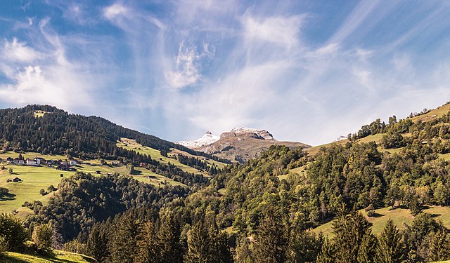
Nederlands: Zicht op de zuidflank van de Voor-Rijn vanuit Waltensburg/Vuorz (Graubünden). Bergtochten in de omgeving van Waltensburg/Vuorz (1003 meter), Breil-Brigels en Andiast in Graubünden. Het grootste kanton van Zwitserland.
English: View of the south-exposed flank of the Vorderrhein (Glarus Alps) from Jörgenberg Castle in Waltensburg/Vuorz (Graubünden). Mountain tours in the vicinity of Waltensburg/Vuorz (1003 meters), Breil-Brigels and Andiast in Graubünden. The largest canton of Switzerland.
Deutsch: Blick auf die südexponierte Flanke des Vorderrheins (Glarner Alpen) von Burg Jörgenberg in Waltensburg/Vuorz (Graubünden).
Español: Vista de la vertiente sur del Rin anterior desde Waltensburg/Vuorz, cantón de los Grisones, Suiza.
|
| Date | |
| Source | Own work |
| Author | Dominicus Johannes Bergsma |
| Other versions |
|
_01.jpg)
_03.jpg)
_02.jpg)
_04.jpg&action=edit§ion=1)
| Camera location | | View this and other nearby images on: OpenStreetMap |
|---|
_04.jpg¶ms=046.780500_N_0009.138180_E_globe:Earth_type:camera__&language=en)
Licensing[edit]
_04.jpg&action=edit§ion=2)
I, the copyright holder of this work, hereby publish it under the following license:
This file is licensed under the Creative Commons Attribution-Share Alike 4.0 International license.
- You are free:
- to share – to copy, distribute and transmit the work
- to remix – to adapt the work
- Under the following conditions:
- attribution – You must give appropriate credit, provide a link to the license, and indicate if changes were made. You may do so in any reasonable manner, but not in any way that suggests the licensor endorses you or your use.
- share alike – If you remix, transform, or build upon the material, you must distribute your contributions under the same or compatible license as the original.
| Annotations | This image is annotated: View the annotations at Commons |
_04.jpg)
Assessment[edit]
_04.jpg&action=edit§ion=3)
|
_04.jpg)
This image has been assessed using the Quality image guidelines and is considered a Quality image.
|
This image was selected as picture of the day on Wikimedia Commons for 14 July 2023. It was captioned as follows: Other languages:
Čeština: Pohled na jižní část údolí toku řeky Přední Rýn, jeden ze zdrojů velké evropské řeky Rýna z oblasti švýcarské vesnice Waltensburg/Vuorz. Español: Vista de la vertiente sur del Rin anterior desde Waltensburg/Vuorz, cantón de los Grisones, Suiza. Italiano: Vista del versante sud del Reno Anteriore dalla frazione di Waltensburg/Vuorz nel Canton Grigioni in Svizzera. Nederlands: Landschap nabij Waltensburg/Vuorz, gelegen op de linkeroever van de Voor-Rijn in het Zwitserse kanton Graubünden Português: Vista do flanco sul do Vorderrhein visto da comuna suíça de Waltensburg/Vuorz, cantão dos Grisões. Русский: Виды южной части Переднего Рейна. Вальтенсбург, кантон Граубюнден, Швейцария |
File history
Click on a date/time to view the file as it appeared at that time.
| Date/Time | Thumbnail | Dimensions | User | Comment | |
|---|---|---|---|---|---|
| current | 17:00, 7 February 2023 | | 4,968 × 2,910 (12.43 MB) | Famberhorst (talk | contribs) | Verfijning. |
| 12:28, 7 February 2023 |  | 4,968 × 2,910 (12.33 MB) | Famberhorst (talk | contribs) | Diverse correcties. | |
| 17:26, 6 October 2022 |  | 4,968 × 2,910 (12.32 MB) | Famberhorst (talk | contribs) | uitsnede | |
| 05:50, 29 September 2022 |  | 4,968 × 3,312 (14.81 MB) | Famberhorst (talk | contribs) | Uploaded own work with UploadWizard |
You cannot overwrite this file.
File usage on Commons
The following 34 pages use this file:
- User:Andrew J.Kurbiko/POTD/2023
- User:Famberhorst/Bergtochten in de omgeving van Waltensburg/Vuorz, in Graubünden, kanton in Zwitserland. (2022)
- User:Yasir72.multan/POTD Year
- User talk:Famberhorst
- Commons:Featured picture candidates/File:Zuidflank van de Vorderrhein 18-09-2022. (d.j.b) 04.jpg
- Commons:Featured picture candidates/Log/February 2023
- Commons:Featured pictures/Places/Natural/Switzerland
- Commons:Featured pictures/chronological/2023-A
- Commons:Featured pictures/chronological/February 2023
- Commons:Picture of the Year/2023/Candidates
- Commons:Picture of the Year/2023/R1/Gallery/2023-A
- Commons:Picture of the Year/2023/R1/Gallery/ALL
- Commons:Picture of the Year/2023/R1/Gallery/M02
- Commons:Picture of the Year/2023/R1/Gallery/Nature views
- Commons:Quality images/Subject/Places/Natural structures/archive 2022
- Commons:Quality images candidates/Archives December 27 2022
- File:Zuidflank van de Vorderrhein 18-09-2022. (d.j.b) 01.jpg
- File:Zuidflank van de Vorderrhein 18-09-2022. (d.j.b) 02.jpg
- File:Zuidflank van de Vorderrhein 18-09-2022. (d.j.b) 03.jpg
- Template:Potd/2023-07
- Template:Potd/2023-07-14
- Template:Potd/2023-07-14 (cs)
- Template:Potd/2023-07-14 (de)
- Template:Potd/2023-07-14 (en)
- Template:Potd/2023-07-14 (es)
- Template:Potd/2023-07-14 (fr)
- Template:Potd/2023-07-14 (hu)
- Template:Potd/2023-07-14 (it)
- Template:Potd/2023-07-14 (mk)
- Template:Potd/2023-07-14 (myv)
- Template:Potd/2023-07-14 (nl)
- Template:Potd/2023-07-14 (pt)
- Template:Potd/2023-07-14 (ru)
- Template:Potd/2023-07-14 (uk)
File usage on other wikis
The following other wikis use this file:
- Usage on alt.wikipedia.org
- Usage on av.wikipedia.org
- Usage on bn.wikipedia.org
- Usage on cv.wikipedia.org
- Usage on fr.wikipedia.org
- Usage on hu.wikipedia.org
- Usage on kk.wikipedia.org
- Usage on ko.wikipedia.org
- Usage on lez.wikipedia.org
- Usage on mk.wikipedia.org
- Usage on os.wikipedia.org
- Usage on pt.wikipedia.org
- Usage on ru.wikipedia.org
- Usage on sah.wikipedia.org
- Usage on uk.wikipedia.org
- Usage on uz.wikipedia.org
- Usage on vep.wikipedia.org
- Usage on zh.wikipedia.org
Metadata
_04.jpg&oldid=865374334)
Categories:
- Andiast
- Clouds and blue sky in Switzerland
- Clouds in the canton of Graubünden
- Glarner Alps
- Landscapes of the canton of Graubünden
- Mountains in the canton of Graubünden
- Panoramics in the canton of Graubünden
- Views from Burg Jörgenberg (Waltensburg)
- Vorderrhein
- Waltensburg/Vuorz
- September 2022 in the canton of Graubünden
- Long exposure photography in nature
- Long exposure photographs of Switzerland
- Long exposure photography of landscapes
- POTD Notification by Famberhorst
- Piz Fluaz