File:Zabriskies Point panoramique2016.jpg
Jump to navigation
Jump to search

Size of this preview: 800 × 269 pixels. Other resolutions: 320 × 108 pixels | 640 × 215 pixels | 1,024 × 344 pixels | 1,280 × 430 pixels | 2,560 × 861 pixels | 9,046 × 3,041 pixels.
Original file (9,046 × 3,041 pixels, file size: 19.74 MB, MIME type: image/jpeg)
Captions
Captions
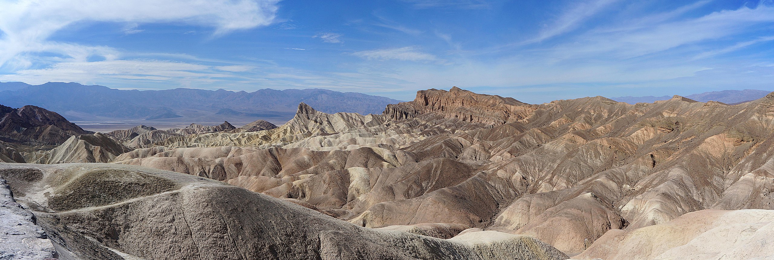
Zabriskie Point in Death Valley California.
Summary
[edit]| Description |
English: Zabriskie Point in Death Valley California. |
||||||||||||||||||||
| Date | Taken on 13 October 2016, 21:26:18 | ||||||||||||||||||||
| Source | Own work | ||||||||||||||||||||
| Author |
|
||||||||||||||||||||
| Permission (Reusing this file) |
|
||||||||||||||||||||
.jpg)

| Camera location | | View this and other nearby images on: OpenStreetMap |
|---|
Assessment
[edit]
|
Licensing
[edit]
I, the copyright holder of this work, hereby publish it under the following licenses:

|
Permission is granted to copy, distribute and/or modify this document under the terms of the GNU Free Documentation License, Version 1.2 or any later version published by the Free Software Foundation; with no Invariant Sections, no Front-Cover Texts, and no Back-Cover Texts. A copy of the license is included in the section entitled GNU Free Documentation License. |
This file is licensed under the Creative Commons Attribution-Share Alike Attribution-Share Alike 4.0 International, 3.0 Unported, 2.5 Generic, 2.0 Generic and 1.0 Generic license.
- You are free:
- to share – to copy, distribute and transmit the work
- to remix – to adapt the work
- Under the following conditions:
- attribution – You must give appropriate credit, provide a link to the license, and indicate if changes were made. You may do so in any reasonable manner, but not in any way that suggests the licensor endorses you or your use.
- share alike – If you remix, transform, or build upon the material, you must distribute your contributions under the same or compatible license as the original.
You may select the license of your choice.
File history
Click on a date/time to view the file as it appeared at that time.
| Date/Time | Thumbnail | Dimensions | User | Comment | |
|---|---|---|---|---|---|
| current | 19:15, 8 August 2018 | 9,046 × 3,041 (19.74 MB) | Pierre André Leclercq (talk | contribs) | done a bit sharperness | |
| 21:05, 7 August 2018 | 9,046 × 3,041 (14.94 MB) | Pierre André Leclercq (talk | contribs) | I've removed dust spots in various parts of the photo, though especially the right half | ||
| 09:23, 22 October 2016 | 9,046 × 3,041 (14.31 MB) | Pierre André Leclercq (talk | contribs) |
You cannot overwrite this file.
File usage on Commons
The following 19 pages use this file:
- Great Basin (United States)
- User:Eatcha/POTY-2018-Round-1-Results
- User:Pierre André Leclercq/Gallery/Amérique du Nord/USA
- User:Pierre André Leclercq/Quality and valued images
- User:Pierre André Leclercq/gallery/2016/2ème semestre
- User talk:Pierre André Leclercq/Archive 2
- User talk:Pierre André Leclercq/Archive 6
- Commons:Featured picture candidates/File:Zabriskies Point panoramique2016.jpg
- Commons:Featured picture candidates/Log/August 2018
- Commons:Featured pictures/Places/Natural/United States
- Commons:Featured pictures/chronological/2018-B
- Commons:Picture of the Year/2018/Candidates
- Commons:Picture of the Year/2018/R1/Gallery/2018-B
- Commons:Picture of the Year/2018/R1/Gallery/ALL
- Commons:Picture of the Year/2018/R1/Gallery/M08
- Commons:Picture of the Year/2018/R1/Gallery/Nature views
- Commons:Picture of the Year/2018/R1/v/Zabriskies Point panoramique2016.jpg
- Commons:Quality images/Subject/Places/Mixed/Panorama/Archive 2016
- Commons:Quality images candidates/Archives December 16 2016
File usage on other wikis
The following other wikis use this file:
- Usage on de.wikipedia.org
- Usage on en.wikipedia.org
- Usage on fr.wikipedia.org
- Usage on kw.wikipedia.org
- Usage on nl.wikipedia.org