File:WikiGTME Correlation between continental plate symmetry (to equator), extinction and sea level.jpg
Jump to navigation
Jump to search

Size of this preview: 522 × 599 pixels. Other resolutions: 209 × 240 pixels | 547 × 628 pixels.
Original file (547 × 628 pixels, file size: 102 KB, MIME type: image/jpeg)
Captions
Captions
Add a one-line explanation of what this file represents
Summary[edit]
,_extinction_and_sea_level.jpg&action=edit§ion=1)
| Description |
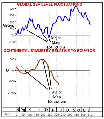
English: The chart displays several graphs. The sea level graph is derived from the Phanerozoic sea level chart (Hallam et al.). The graphs of continental plate movement relative to the equator is derived from ‘Plate tectonics may control geomagnetic reversal frequency’ (Pétrélis, Besse and Valet).
Three of the major mass extinctions (of about 250Ma, 200Ma and 65Ma) clearly show the movement of the continental mass (of a consolidated Pangea) moving toward the equator supporting the Gravity Theory of Mass Extinction’s claim that the primary extinction mechanism was an increase in surface gravitation. |
| Date | |
| Source | Own work |
| Author | Jstheorist |
Licensing[edit]
,_extinction_and_sea_level.jpg&action=edit§ion=2)
I, the copyright holder of this work, hereby publish it under the following license:
This file is licensed under the Creative Commons Attribution-Share Alike 3.0 Unported license.
- You are free:
- to share – to copy, distribute and transmit the work
- to remix – to adapt the work
- Under the following conditions:
- attribution – You must give appropriate credit, provide a link to the license, and indicate if changes were made. You may do so in any reasonable manner, but not in any way that suggests the licensor endorses you or your use.
- share alike – If you remix, transform, or build upon the material, you must distribute your contributions under the same or compatible license as the original.
File history
Click on a date/time to view the file as it appeared at that time.
| Date/Time | Thumbnail | Dimensions | User | Comment | |
|---|---|---|---|---|---|
| current | 18:31, 5 September 2012 | | 547 × 628 (102 KB) | Jstheorist (talk | contribs) | {{Information |Description ={{en|1=The chart displays several graphs. The sea level graph is derived from the Phanerozoic sea level chart (Hallam et al.). The graphs of continental plate movement relative to the equator is derived from ‘Plate tec... |
You cannot overwrite this file.
File usage on Commons
There are no pages that use this file.
,_extinction_and_sea_level.jpg&oldid=508781321)