File:WGSRPD Southern America with regions.svg
Jump to navigation
Jump to search

Size of this PNG preview of this SVG file: 555 × 600 pixels. Other resolutions: 222 × 240 pixels | 444 × 480 pixels | 710 × 768 pixels | 947 × 1,024 pixels | 1,894 × 2,048 pixels | 740 × 800 pixels.
Original file (SVG file, nominally 740 × 800 pixels, file size: 434 KB)
Captions
Captions
Add a one-line explanation of what this file represents
Summary[edit]
| Description |
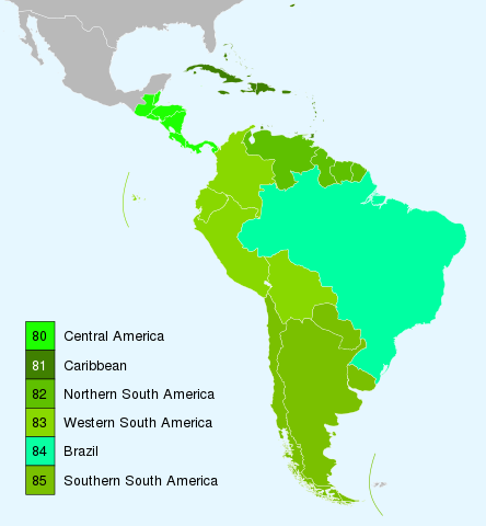
English: Southern America, as defined by the World Geographical Scheme for Recording Plant Distributions (different from the traditional geographical South America as it comprises the Caribbean, Central America and South America), showing the regions into which it is divided. |
| Date | |
| Source |
This file was derived from: Latin America - First level political divisions.svg:  The WGSRPD regions are coloured in different shades of green. |
| Author |
Original: User:Cocoloi Derived: Peter coxhead |
| SVG development |
Licensing[edit]
I, the copyright holder of this work, hereby publish it under the following license:
This file is licensed under the Creative Commons Attribution-Share Alike 4.0 International license.
- You are free:
- to share – to copy, distribute and transmit the work
- to remix – to adapt the work
- Under the following conditions:
- attribution – You must give appropriate credit, provide a link to the license, and indicate if changes were made. You may do so in any reasonable manner, but not in any way that suggests the licensor endorses you or your use.
- share alike – If you remix, transform, or build upon the material, you must distribute your contributions under the same or compatible license as the original.
| Annotations | This image is annotated: View the annotations at Commons |
File history
Click on a date/time to view the file as it appeared at that time.
| Date/Time | Thumbnail | Dimensions | User | Comment | |
|---|---|---|---|---|---|
| current | 18:00, 30 July 2015 | | 740 × 800 (434 KB) | Peter coxhead (talk | contribs) | Had also omitted Aruba to include Aruba in colour of Caribbean region; now fixed. |
| 16:49, 30 July 2015 |  | 740 × 800 (434 KB) | Peter coxhead (talk | contribs) | Had omitted Bermuda before; now added. | |
| 20:36, 18 July 2015 |  | 740 × 800 (434 KB) | Peter coxhead (talk | contribs) | User created page with UploadWizard |
You cannot overwrite this file.
File usage on Commons
The following page uses this file:
File usage on other wikis
The following other wikis use this file:
- Usage on cs.wikipedia.org
- Usage on en.wikipedia.org
- Usage on es.wikipedia.org
- Usage on hr.wikipedia.org
- Usage on tr.wikipedia.org