File:Vilayet of Kosovo (1881–1912) map.png
Jump to navigation
Jump to search

Size of this preview: 645 × 599 pixels. Other resolutions: 258 × 240 pixels | 517 × 480 pixels | 820 × 762 pixels.
Original file (820 × 762 pixels, file size: 74 KB, MIME type: image/png)
Captions
Captions
Add a one-line explanation of what this file represents
Summary[edit]
_map.png&action=edit§ion=1)
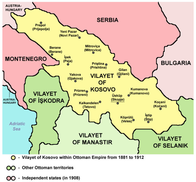
VILAJETI I KOSOVËS NËN PERANDORINË OSMANE NGA 1881 DERI MË 1912
Source and licence[edit]
_map.png&action=edit§ion=2)

|
This map has been uploaded by Electionworld from en.wikipedia.org to enable the |
| This work has been released into the public domain by its author, PANONIAN. This applies worldwide. In some countries this may not be legally possible; if so: |
References[edit]
_map.png&action=edit§ion=3)
Main reference:
- Created according to historical map from this book: Petrit Imami, Srbi i Albanci kroz vekove, Beograd, 2000.
Secondary references with similar maps:
- Noel Malcolm, Kosovo - A Short History, Pan Books, London, 2002.
- Školski istorijski atlas, Zavod za izdavanje udžbenika SR Srbije, Beograd, 1970.
- Sve srpske mape - od šestog veka do Pariza, Specijalno izdanje BLICA, Decembar 1995. godine.
- http://terkepek.adatbank.transindex.ro/kepek/netre/95.gif
- http://www.panmacedonian.info/macedonism_thesis_files/Macedonism%20of%20the%20Slavs_img_19.jpg
- http://www.zum.de/whkmla/histatlas/balkans/rumelia1891t.gif
- http://www.kosovo.net/sk/rastko-kosovo/istorija/kosovo_chronicles/kc_figure1.gif
- http://www.hri.org/docs/macque/map3.gif
- http://remmm.revues.org/docannexe/image/305/img-1-small480.png
- http://www.cairn.info/loadimg.php?FILE=GMCC/GMCC_202/GMCC_202_0113/fullGMCC_id9782130527213_pu2001-02d_pa01-da16_art07_img001.jpg
File history
Click on a date/time to view the file as it appeared at that time.
| Date/Time | Thumbnail | Dimensions | User | Comment | |
|---|---|---|---|---|---|
| current | 13:16, 11 September 2012 | | 820 × 762 (74 KB) | PANONIAN (talk | contribs) | {{Information |Description ={{en|1=cosmetic changes}} |Source =cosmetic changes |Author =cosmetic changes |Date = |Permission = |other_versions = }} |
| 07:17, 6 April 2011 |  | 762 × 719 (61 KB) | PANONIAN (talk | contribs) | Reverted to version as of 08:44, 5 April 2011 - trying to solve thumbnail problem | |
| 07:14, 6 April 2011 |  | 762 × 719 (61 KB) | PANONIAN (talk | contribs) | Reverted to version as of 08:44, 5 April 2011 - trying to solve thumbnail problem | |
| 07:14, 6 April 2011 |  | 762 × 719 (64 KB) | PANONIAN (talk | contribs) | Reverted to version as of 20:05, 2 June 2009 - trying to solve thumbnail problem | |
| 08:44, 5 April 2011 |  | 762 × 719 (61 KB) | PANONIAN (talk | contribs) | aesthetical improvement | |
| 20:05, 2 June 2009 |  | 762 × 719 (64 KB) | PANONIAN (talk | contribs) | ||
| 23:31, 21 December 2006 |  | 624 × 516 (185 KB) | Electionworld (talk | contribs) | {{ew|en|PANONIAN}} {{PD-user|PANONIAN}} Category:Maps of Kosovo |
You cannot overwrite this file.
File usage on Commons
The following 6 pages use this file:
- Atlas of Kosovo
- Atlas of North Macedonia
- File:Kosovo03.png (file redirect)
- File:Vilayet of Kosovo (1881–1913) map.png (file redirect)
_map.png&redirect=no)
File usage on other wikis
The following other wikis use this file:
- Usage on af.wikipedia.org
- Usage on ast.wikipedia.org
- Usage on be.wikipedia.org
- Usage on bg.wikipedia.org
- Usage on bn.wikipedia.org
- Usage on br.wikipedia.org
- Usage on bs.wikipedia.org
- Usage on ca.wikipedia.org
- Usage on de.wikipedia.org
- Usage on en.wikipedia.org
- Usage on es.wikipedia.org
- Usage on fi.wikipedia.org
- Usage on fr.wikipedia.org
- Usage on gl.wikipedia.org
- Usage on hr.wikipedia.org
- Usage on ht.wikipedia.org
- Usage on hu.wikipedia.org
- Usage on it.wikipedia.org
- Usage on ja.wikipedia.org
- Usage on lt.wikipedia.org
- Usage on lv.wikipedia.org
- Usage on mk.wikipedia.org
- Usage on nl.wikipedia.org
- Usage on no.wikipedia.org
- Usage on pl.wikipedia.org
View more global usage of this file.
_map.png)
_map.png&oldid=698727755)
Categories:
- Maps of the history of Kosovo under Ottoman Empire
- Maps of the history of North Macedonia under Ottoman Empire
- Maps of the Ottoman period in the history of Serbia
- Maps of the history of Montenegro under Ottoman and Venetian rule
- Maps of vilayets of the Ottoman Empire
- Maps of the Ottoman Empire in the 19th century
- Maps of the Ottoman Empire in the 20th-century
- Vilajeti i Kosovës