File:US Virgin Islands.png
Jump to navigation
Jump to search

Size of this preview: 343 × 600 pixels. Other resolutions: 137 × 240 pixels | 505 × 883 pixels.
Original file (505 × 883 pixels, file size: 633 KB, MIME type: image/png)
Captions
Captions
Add a one-line explanation of what this file represents
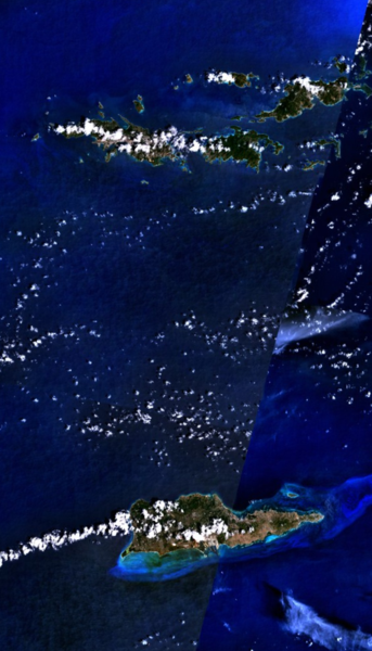
U.S. Virgin Islands - NASA NLT Landsat 7 (Visible Color) Satellite Image
| This file is in the public domain in the United States because it was solely created by NASA. NASA copyright policy states that "NASA material is not protected by copyright unless noted". (See Template:PD-USGov, NASA copyright policy page or JPL Image Use Policy.) | ||
 |
Warnings:
|
File history
Click on a date/time to view the file as it appeared at that time.
| Date/Time | Thumbnail | Dimensions | User | Comment | |
|---|---|---|---|---|---|
| current | 02:42, 11 April 2005 | | 505 × 883 (633 KB) | Bollar (talk | contribs) | U.S. Virgin Islands - NASA NLT Landsat 7 (Visible Color) Satellite Image {{PD-USGov-NASA}} Category:Caribbean |
You cannot overwrite this file.
File usage on Commons
The following 2 pages use this file:
File usage on other wikis
The following other wikis use this file:
- Usage on af.wikipedia.org
- Usage on azb.wikipedia.org
- Usage on da.wikipedia.org
- Usage on da.wikibooks.org
- Usage on en.wikipedia.org
- Usage on fo.wikipedia.org
- Usage on gl.wikipedia.org
- Usage on id.wikipedia.org
- Usage on no.wikipedia.org
- Usage on pl.wikipedia.org
- Usage on sr.wikipedia.org
- Usage on uk.wikipedia.org