File:TratadoDeSevres1920.svg
Jump to navigation
Jump to search

Size of this PNG preview of this SVG file: 800 × 480 pixels. Other resolutions: 320 × 192 pixels | 1,024 × 615 pixels | 1,280 × 768 pixels | 2,560 × 1,536 pixels | 1,273 × 764 pixels.
Original file (SVG file, nominally 1,273 × 764 pixels, file size: 732 KB)
Captions
Captions
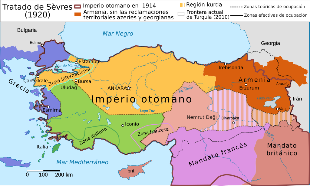
Map of the territorial changes stipulated by the Treaty of Sèvres
| Description |
Español: Partición de Anatolia según el Tratado de Sèvres. Nacimiento de Turquía, concesiones territoriales y zonas de influencia de las potencias.
English: Map about treaty of sevres in Italian.
Deutsch: Karte zum Vertrag von Sèvres (Osmanisches Reich) in Italienisch.
Italiano: Spartizione dell'anatolia secondo il trattato di Sèvres (Impero Ottomano). Nascita della Turchia concessioni territoriali e zone di influenza
Русский: Предполагавшийся по Севрскому договору раздел Турции. |
| Date | (UTC) |
| Source | |
| Author |
|
| Other versions |
|


| This is a retouched picture, which means that it has been digitally altered from its original version. Modifications: Spanish version, information from both maps merged. The original can be viewed here: Treaty sevres otoman de.svg:
|
I, the copyright holder of this work, hereby publish it under the following license:
This file is licensed under the Creative Commons Attribution-Share Alike 3.0 Unported license.
- You are free:
- to share – to copy, distribute and transmit the work
- to remix – to adapt the work
- Under the following conditions:
- attribution – You must give appropriate credit, provide a link to the license, and indicate if changes were made. You may do so in any reasonable manner, but not in any way that suggests the licensor endorses you or your use.
- share alike – If you remix, transform, or build upon the material, you must distribute your contributions under the same or compatible license as the original.
Original upload log[edit]
This image is a derivative work of the following images:
- File:Treaty_sevres_otoman_de.svg licensed with Cc-by-sa-3.0
- 2009-04-27T12:04:43Z Don-kun 1250x650 (355900 Bytes) change colors
- 2009-04-25T15:06:14Z Don-kun 1250x650 (361672 Bytes) some small changes
- 2009-04-25T14:52:45Z Don-kun 1250x650 (361569 Bytes) change some text, caption
- 2009-04-24T11:29:59Z Don-kun 1250x650 (357706 Bytes) {{Information |Description={{en|1=Map about treaty of sevres in German.}} {{de|1=Karte zum Vertrag von Sèvres (Osmanisches Reich) in Deutsch. }} |Source=derivate of [[:File:Vertrag sevres otoman.svg]] by [[:de:Benutzer:Thire
Uploaded with derivativeFX
File history
Click on a date/time to view the file as it appeared at that time.
| Date/Time | Thumbnail | Dimensions | User | Comment | |
|---|---|---|---|---|---|
| current | 21:53, 31 May 2019 | | 1,273 × 764 (732 KB) | Rowanwindwhistler (talk | contribs) | Minor changes, fake text added |
| 21:53, 17 November 2015 |  | 1,273 × 764 (426 KB) | Rowanwindwhistler (talk | contribs) | More layers, better colours, better names. | |
| 22:57, 20 February 2010 |  | 1,273 × 764 (296 KB) | Rowanwindwhistler (talk | contribs) | {{Information |Description={{es|1=Partición de Anatolia según el Tratado de Sèvres. Nacimiento de Turquía, concesiones territoriales y zonas de influencia de las potencias.}} {{en|1=Map about treaty of sevres in German.}} {{de|1=Karte zum Vertrag von |
You cannot overwrite this file.
File usage on Commons
The following 8 pages use this file:
File usage on other wikis
The following other wikis use this file:
- Usage on ast.wikipedia.org
- Usage on ca.wikipedia.org
- Usage on de.wikipedia.org
- Usage on eo.wikipedia.org
- Usage on es.wikipedia.org
- Usage on hy.wikipedia.org
- Usage on uk.wikipedia.org