File:The Nimrod Glacier flowing around an ice peak seen by TerraSAR-X.jpg
Jump to navigation
Jump to search

Size of this preview: 344 × 599 pixels. Other resolutions: 138 × 240 pixels | 276 × 480 pixels | 441 × 768 pixels | 588 × 1,024 pixels | 1,365 × 2,375 pixels.
Original file (1,365 × 2,375 pixels, file size: 2.42 MB, MIME type: image/jpeg)
Captions
Captions
Add a one-line explanation of what this file represents
Summary[edit]
| Description |
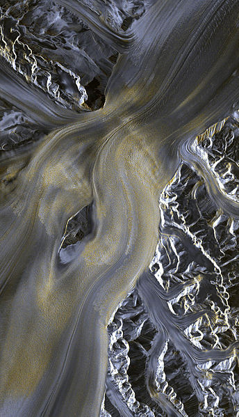
English: The detailed picture of around 30 kilometres sent from the TerraSAR-X radar satellite shows the Antarctic Nimrod Glacier flowing around the Kon-Tiki Nunatak, a rock protruding through the ice sheet. It is even possible to pick out the fissures in the glacier’s main body. Polski: Radarowe zdjęcie antarktycznego lodowca Nimrod wykonane przez niemieckiego satelitę TerraSAR-X.
Zdjęcie ukazuje około 30 kilometrów lodowca, który opływa górę Kon-Tiki Nunatak, powodując jej erozję. |
| Date | Unknown date |
| Source | http://www.dlr.de/dlr/en/desktopdefault.aspx/tabid-10422/ |
| Author | DLR |
Licensing[edit]
This file is licensed under the Creative Commons Attribution 3.0 Unported license.
- You are free:
- to share – to copy, distribute and transmit the work
- to remix – to adapt the work
- Under the following conditions:
- attribution – You must give appropriate credit, provide a link to the license, and indicate if changes were made. You may do so in any reasonable manner, but not in any way that suggests the licensor endorses you or your use.
File history
Click on a date/time to view the file as it appeared at that time.
| Date/Time | Thumbnail | Dimensions | User | Comment | |
|---|---|---|---|---|---|
| current | 08:54, 8 May 2012 | | 1,365 × 2,375 (2.42 MB) | NH2501 (talk | contribs) |
You cannot overwrite this file.
File usage on Commons
The following 2 pages use this file:
File usage on other wikis
The following other wikis use this file:
- Usage on ar.wikipedia.org
- Usage on bg.wikipedia.org
- Usage on ceb.wikipedia.org
- Usage on en.wikipedia.org
- Usage on en.wikibooks.org
- Usage on he.wikipedia.org
- Usage on it.wikipedia.org
- Usage on nn.wikipedia.org
- Usage on pl.wikipedia.org
- Usage on www.wikidata.org