File:Territories ceded by Bulgaria to SCS Kingdom map.png
Jump to navigation
Jump to search
Size of this preview: 282 × 598 pixels. Other resolutions: 113 × 240 pixels | 226 × 480 pixels | 362 × 768 pixels | 1,262 × 2,678 pixels.
Original file (1,262 × 2,678 pixels, file size: 112 KB, MIME type: image/png)
Captions
Captions
Add a one-line explanation of what this file represents

|
This historical map image could be re-created using vector graphics as an SVG file. This has several advantages; see Commons:Media for cleanup for more information. If an SVG form of this image is available, please upload it and afterwards replace this template with
{{vector version available|new image name}}.
It is recommended to name the SVG file “Territories ceded by Bulgaria to SCS Kingdom map.svg”—then the template Vector version available (or Vva) does not need the new image name parameter. |
Summary[edit]
| Description |
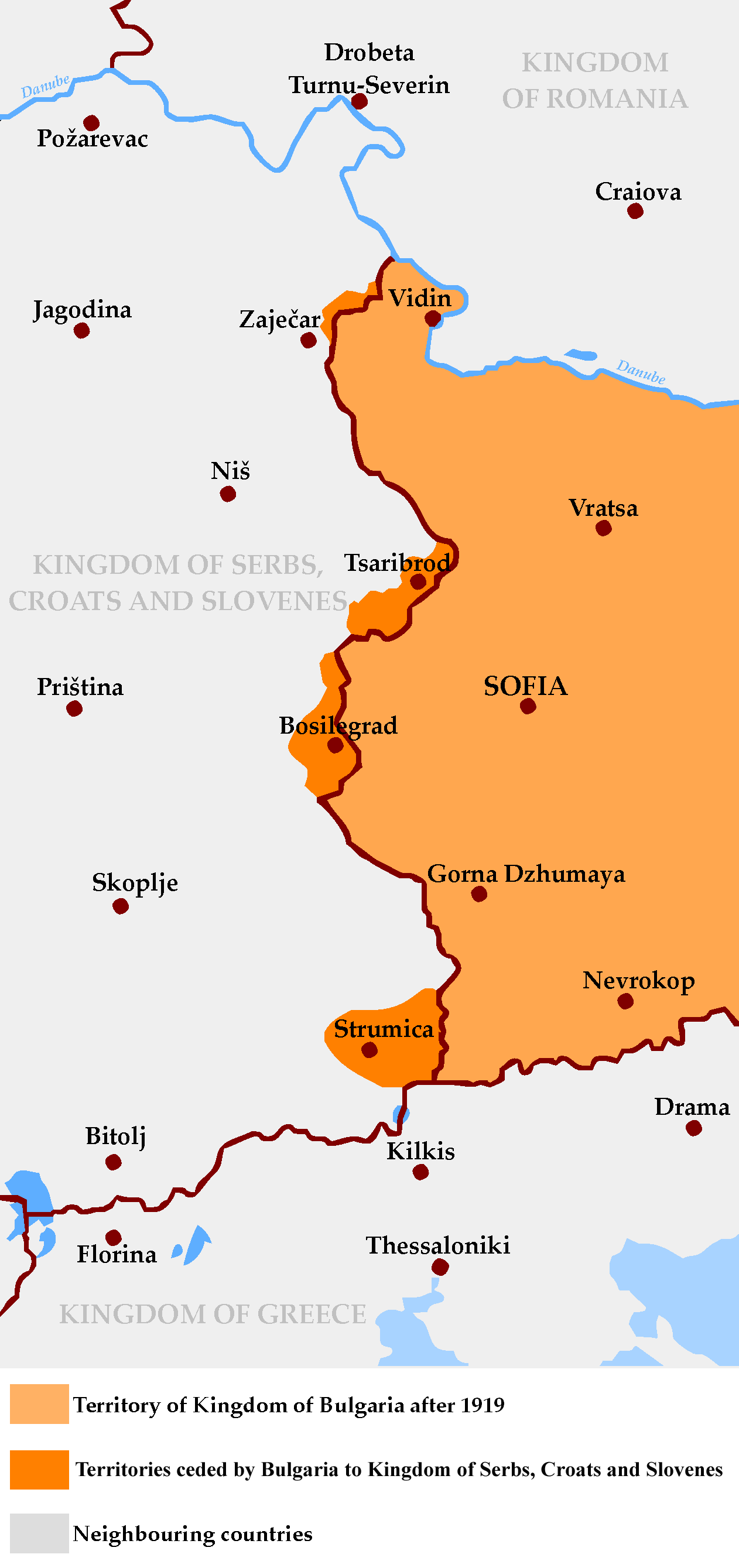
English: Map of Territories ceded by Bulgaria to SCS Kingdom after Treatry of Neuilly-sur-Siene in 1919
Български: Карта на Западните покрайнини след Ньойския договор от 1919 г. |
| Date | |
| Source | Own work |
| Author | Пакко |
Licensing[edit]
I, the copyright holder of this work, hereby publish it under the following licenses:
This file is licensed under the Creative Commons Attribution-Share Alike 3.0 Unported license.
- You are free:
- to share – to copy, distribute and transmit the work
- to remix – to adapt the work
- Under the following conditions:
- attribution – You must give appropriate credit, provide a link to the license, and indicate if changes were made. You may do so in any reasonable manner, but not in any way that suggests the licensor endorses you or your use.
- share alike – If you remix, transform, or build upon the material, you must distribute your contributions under the same or compatible license as the original.

|
Permission is granted to copy, distribute and/or modify this document under the terms of the GNU Free Documentation License, Version 1.2 or any later version published by the Free Software Foundation; with no Invariant Sections, no Front-Cover Texts, and no Back-Cover Texts. A copy of the license is included in the section entitled GNU Free Documentation License. |
You may select the license of your choice.
File history
Click on a date/time to view the file as it appeared at that time.
| Date/Time | Thumbnail | Dimensions | User | Comment | |
|---|---|---|---|---|---|
| current | 19:54, 12 June 2011 | | 1,262 × 2,678 (112 KB) | 123iti (talk | contribs) | correct description |
| 14:39, 26 October 2008 |  | 1,262 × 2,678 (121 KB) | Пакко (talk | contribs) | {{Information |Description={{en|1=Map of Western Outlands after Treatry of Neuilly-sur-Siene in 1919}} {{bg|1=Карта на Западните покрайнини след Ньойския договор от 1919 г.}} |Source=Own work by uploader |Au |
You cannot overwrite this file.
File usage on Commons
The following 3 pages use this file:
- Atlas of North Macedonia
- Atlas of Serbia
- File:Western Outlands map.png (file redirect)
File usage on other wikis
The following other wikis use this file:
- Usage on bg.wikipedia.org
- Usage on cs.wikipedia.org
- Usage on de.wikipedia.org
- Usage on en.wikipedia.org
- Usage on fa.wikipedia.org
- Usage on hr.wikipedia.org
- Usage on nl.wikipedia.org
- Usage on pt.wikipedia.org
- Usage on sk.wikipedia.org
- Usage on sq.wikipedia.org
- Usage on sr.wikipedia.org
- Usage on tr.wikipedia.org
- Usage on zh.wikipedia.org