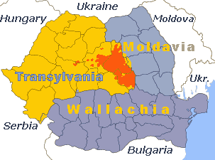
File:Székelyföld.png
From Wikimedia Commons, the free media repository
Jump to navigation
Jump to search
Székelyföld.png (303 × 225 pixels, file size: 17 KB, MIME type: image/png)
File information
Structured data
Captions
Captions
Add a one-line explanation of what this file represents
Summary[edit]
| DescriptionSzékelyföld.png | Map of the Székelyföld (orange) in Transylvania (yellow), in Romania |
| Date | 31 January 2007 (original upload date) |
| Source | No machine-readable source provided. Own work assumed (based on copyright claims). |
| Author | No machine-readable author provided. Dionysos1~commonswiki assumed (based on copyright claims). |
Licensing[edit]
| Public domainPublic domainfalsefalse |
| I, the copyright holder of this work, release this work into the public domain. This applies worldwide. In some countries this may not be legally possible; if so: I grant anyone the right to use this work for any purpose, without any conditions, unless such conditions are required by law. |
File history
Click on a date/time to view the file as it appeared at that time.
| Date/Time | Thumbnail | Dimensions | User | Comment | |
|---|---|---|---|---|---|
| current | 12:26, 4 November 2017 |  | 303 × 225 (17 KB) | Julieta39 (talk | contribs) | Details |
| 17:27, 4 April 2013 |  | 277 × 200 (22 KB) | Spiridon Ion Cepleanu (talk | contribs) | The Székelyföld is not exactly the area of Maros, Hargita & Kovaszna (Haromszek) actual counties. Székelyföld include a part of Also-Feher/Torda county around Gyeres, but not all the Maros county. See File:MagyarsOutsideHungary.png | |
| 18:35, 31 January 2007 |  | 277 × 200 (13 KB) | Dionysos1~commonswiki (talk | contribs) |
You cannot overwrite this file.
File usage on Commons
The following page uses this file:
File usage on other wikis
The following other wikis use this file:
- Usage on de.wikipedia.org
- Usage on fr.wikipedia.org
- Usage on nl.wikipedia.org
- Usage on zh.wikipedia.org
Metadata
This file contains additional information such as Exif metadata which may have been added by the digital camera, scanner, or software program used to create or digitize it. If the file has been modified from its original state, some details such as the timestamp may not fully reflect those of the original file. The timestamp is only as accurate as the clock in the camera, and it may be completely wrong.
| Horizontal resolution | 28.35 dpc |
|---|---|
| Vertical resolution | 28.35 dpc |
