File:Sucos Lautem.png
Jump to navigation
Jump to search

Size of this preview: 800 × 545 pixels. Other resolutions: 320 × 218 pixels | 640 × 436 pixels | 1,024 × 697 pixels | 1,280 × 871 pixels | 2,405 × 1,637 pixels.
Original file (2,405 × 1,637 pixels, file size: 433 KB, MIME type: image/png)
Captions
Captions
Add a one-line explanation of what this file represents

|
This locator map image could be re-created using vector graphics as an SVG file. This has several advantages; see Commons:Media for cleanup for more information. If an SVG form of this image is available, please upload it and afterwards replace this template with
{{vector version available|new image name}}.
It is recommended to name the SVG file “Sucos Lautem.svg”—then the template Vector version available (or Vva) does not need the new image name parameter. |
Summary[edit]
| Description |
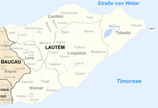
Deutsch: Sucos des Distrikts Lautém/Osttimor nach der Neustrukturierung 2003 |
| Date | |
| Source | Own work |
| Author | J. Patrick Fischer |
Licensing[edit]
I, the copyright holder of this work, hereby publish it under the following license:
This file is licensed under the Creative Commons Attribution-Share Alike 3.0 Unported license.
- You are free:
- to share – to copy, distribute and transmit the work
- to remix – to adapt the work
- Under the following conditions:
- attribution – You must give appropriate credit, provide a link to the license, and indicate if changes were made. You may do so in any reasonable manner, but not in any way that suggests the licensor endorses you or your use.
- share alike – If you remix, transform, or build upon the material, you must distribute your contributions under the same or compatible license as the original.
File history
Click on a date/time to view the file as it appeared at that time.
| Date/Time | Thumbnail | Dimensions | User | Comment | |
|---|---|---|---|---|---|
| current | 18:24, 7 December 2009 | | 2,405 × 1,637 (433 KB) | J. Patrick Fischer (talk | contribs) | uploaded a new version of "File:Sucos Ainaro.png": New version by using File:Administrative map of the Lautem district of East Timor.png of Maximilian Dörrbecker (Chumwa) New geographical names and spelling a |
| 19:16, 17 July 2009 |  | 3,028 × 2,300 (2.86 MB) | J. Patrick Fischer (talk | contribs) | Corrected borders of Iliomar | |
| 18:52, 8 July 2009 |  | 3,028 × 2,300 (2.59 MB) | J. Patrick Fischer (talk | contribs) | Borders of Suco Luro | |
| 18:14, 5 July 2009 |  | 3,028 × 2,300 (2.79 MB) | J. Patrick Fischer (talk | contribs) | Correct new map | |
| 18:09, 5 July 2009 |  | 3,028 × 2,300 (2.86 MB) | J. Patrick Fischer (talk | contribs) | Reverted to version as of 13:05, 11 June 2009 | |
| 18:06, 5 July 2009 |  | 2,075 × 1,265 (1.42 MB) | J. Patrick Fischer (talk | contribs) | Correction borders of Suco Luro | |
| 13:05, 11 June 2009 |  | 3,028 × 2,300 (2.86 MB) | J. Patrick Fischer (talk | contribs) | Triloro -> Tirilolo | |
| 21:00, 4 June 2009 |  | 3,028 × 2,300 (2.81 MB) | J. Patrick Fischer (talk | contribs) | Correction in subdistrict Lauro | |
| 17:57, 1 June 2009 |  | 3,028 × 2,300 (2.81 MB) | J. Patrick Fischer (talk | contribs) | Correction of border between Parlamento and Pairara | |
| 09:54, 1 June 2009 |  | 3,028 × 2,300 (2.78 MB) | J. Patrick Fischer (talk | contribs) | Border of Ililai and Eukisi corrected |
You cannot overwrite this file.
File usage on Commons
The following page uses this file:
File usage on other wikis
The following other wikis use this file: