File:South Kasai in Congo 1961.svg
Jump to navigation
Jump to search

Size of this PNG preview of this SVG file: 630 × 600 pixels. Other resolutions: 252 × 240 pixels | 504 × 480 pixels | 807 × 768 pixels | 1,075 × 1,024 pixels | 2,151 × 2,048 pixels | 1,150 × 1,095 pixels.
Original file (SVG file, nominally 1,150 × 1,095 pixels, file size: 891 KB)
Captions
Captions
Add a one-line explanation of what this file represents
Summary[edit]
| Description |
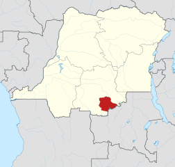
English: Map of secessionist region South Kasai during the Congo Crisis in 1961 |
| Date | |
| Source |
Own work, based on
This vector image includes elements that have been taken or adapted from this file: |
| Author |
TUBS |
Licensing[edit]
I, the copyright holder of this work, hereby publish it under the following licenses:

|
Permission is granted to copy, distribute and/or modify this document under the terms of the GNU Free Documentation License, Version 1.2 or any later version published by the Free Software Foundation; with no Invariant Sections, no Front-Cover Texts, and no Back-Cover Texts. A copy of the license is included in the section entitled GNU Free Documentation License. |
This file is licensed under the Creative Commons Attribution 3.0 Unported license.
- You are free:
- to share – to copy, distribute and transmit the work
- to remix – to adapt the work
- Under the following conditions:
- attribution – You must give appropriate credit, provide a link to the license, and indicate if changes were made. You may do so in any reasonable manner, but not in any way that suggests the licensor endorses you or your use.
You may select the license of your choice.
File history
Click on a date/time to view the file as it appeared at that time.
| Date/Time | Thumbnail | Dimensions | User | Comment | |
|---|---|---|---|---|---|
| current | 17:57, 5 January 2014 | | 1,150 × 1,095 (891 KB) | TUBS (talk | contribs) | |
| 00:18, 5 January 2014 |  | 1,150 × 1,095 (868 KB) | TUBS (talk | contribs) | {{Information |Description= |Source= |Date= |Author= |Permission= |other_versions= }} | |
| 00:11, 5 January 2014 |  | 1,150 × 1,095 (781 KB) | TUBS (talk | contribs) | == {{int:filedesc}} == {{Information |Description ={{en|1=Map of South Kasai in Congo in 1961 (Congo crisis), in German.}} |Source ={{own}}{{AttribSVG|Kongo 1961 map en.png|Don-kun, Uwe Dedering}} ||Author ={{TUBS}} |Date =... |
You cannot overwrite this file.
File usage on Commons
The following page uses this file:
File usage on other wikis
The following other wikis use this file:
- Usage on azb.wikipedia.org
- Usage on cs.wikipedia.org
- Usage on de.wikipedia.org
- Usage on en.wikipedia.org
- Usage on es.wikipedia.org
- Usage on fr.wikipedia.org
- Usage on id.wikipedia.org
- Usage on it.wikipedia.org
- Usage on ja.wikipedia.org
- Usage on nl.wikipedia.org
- Usage on pl.wikipedia.org
- Usage on pt.wikipedia.org
- Usage on sk.wikipedia.org
- Usage on sv.wikipedia.org
- Usage on tr.wikipedia.org
- Usage on uk.wikipedia.org
- Usage on vi.wikipedia.org
- Usage on zh.wikipedia.org