File:Serbia boundaries CIA.jpg
Jump to navigation
Jump to search

Size of this preview: 572 × 599 pixels. Other resolutions: 229 × 240 pixels | 458 × 480 pixels | 655 × 686 pixels.
Original file (655 × 686 pixels, file size: 103 KB, MIME type: image/jpeg)
Captions
Captions
Add a one-line explanation of what this file represents

|
This map has been uploaded by Electionworld from en.wikipedia.org to enable the |


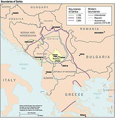
Map from "Kosovo: History of a Balkan Hot Spot", U.S. Central Intelligence Agency, Office of DCI Interagency Balkan Task Force, June 1998.
Used courtesy of the University of Texas Libraries, The University of Texas at Austin.

|
Permission is granted to copy, distribute and/or modify this document under the terms of the GNU Free Documentation License, Version 1.2 or any later version published by the Free Software Foundation; with no Invariant Sections, no Front-Cover Texts, and no Back-Cover Texts. A copy of the license is included in the section entitled GNU Free Documentation License. |
| This file is licensed under the Creative Commons Attribution-Share Alike 3.0 Unported license. | ||
| ||
| This licensing tag was added to this file as part of the GFDL licensing update. |
File history
Click on a date/time to view the file as it appeared at that time.
| Date/Time | Thumbnail | Dimensions | User | Comment | |
|---|---|---|---|---|---|
| current | 18:01, 6 October 2012 | | 655 × 686 (103 KB) | MacedonianBoy (talk | contribs) | small |
| 20:44, 21 December 2006 |  | 655 × 686 (55 KB) | Electionworld (talk | contribs) | {{ew|en|Ninam}} {{badJPEG}} '''Map from "Kosovo: History of a Balkan Hot Spot",''' U.S. Central Intelligence Agency, Office of DCI Interagency Balkan Task Force, June 1998. ''Used courtesy of the University of Texas Libraries, The University of Texas at |
You cannot overwrite this file.
File usage on Commons
The following 5 pages use this file:
File usage on other wikis
The following other wikis use this file:
- Usage on bn.wikipedia.org
- Usage on br.wikipedia.org
- Usage on de.wikipedia.org
- Usage on en.wikipedia.org
- Usage on es.wikipedia.org
- Usage on it.wikipedia.org
- Usage on ja.wikipedia.org
- Usage on pt.wikipedia.org
- Usage on ro.wikipedia.org
Categories:
- Maps of the history of Serbia in the Middle Ages
- Maps of the history of Kosovo in the Middle Ages
- Maps of the history of Bosnia and Herzegovina
- Anachronistic maps
- Maps of the Grand Principality of Serbia
- Maps of the Serbian Empire
- Maps of medieval Bosnian and neighboring states
- CIA World Factbook maps of Bosnia and Herzegovina