File:Sea Ice and Icebergs off East Antarctica - NASA Earth Observatory.jpg
Sea_Ice_and_Icebergs_off_East_Antarctica_-_NASA_Earth_Observatory.jpg (720 × 480 pixels, file size: 124 KB, MIME type: image/jpeg)
Captions
Captions
Summary[edit]
| Description |
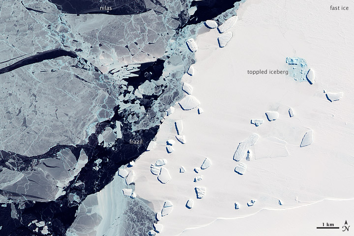
NASA image acquired October 7, 2011 To download the full high res go to: earthobservatory.nasa.gov/IOTD/view.php?id=76197&src=... Though it is all composed of frozen water, ice is hardly uniform. On October 7, 2011, the Advanced Land Imager (ALI) on NASA’s Earth Observing-1 (EO-1) satellite captured this image of a variety of ice types off the coast of East Antarctica. Brilliant white ice fills the right half of this image. It is fast ice, and derives its name from the fact that it holds fast to the shore. This ice is thick enough to completely hide the underlying seawater, hence its brilliant white color. Trapped within the fast ice, and stuck along the edge of it, are icebergs. Icebergs form by calving off ice shelves—thick slabs of ice attached to the coast. Ice shelves can range in thickness from tens to hundreds of meters, and the icebergs that calve off of them can tower over nearby sea ice. One iceberg, drenched with meltwater, has toppled and shattered (image upper right). The water-saturated ice leaves a blue tinge. The icebergs along the edge of the fast ice are likely grounded on the shallow sea floor, and their presence may help hold the fast ice in place. Farther out to sea is pack ice that drifts with winds and currents. Much thinner than the fast ice, the translucent pack ice appears in shades of blue-gray. The pack ice includes some newly formed sea ice. As seawater starts to freeze, it forms tiny crystals known as frazil (image center). Although the individual crystals are only millimeters across, enough of them assembled together are visible from space. Constantly moved by ocean currents, frazil often appears in delicate swirls. Frazil crystals can coalesce into thin sheets of ice known as nilas (image top). Sheets of nilas often slide over each other, eventually merging into thicker layers of ice. NASA Earth Observatory image created by Jesse Allen and Robert Simmon, using EO-1 ALI data provided courtesy of the NASA EO-1 team. Caption by Michon Scott based on image interpretation by Ted Scambos, National Snow and Ice Data Center. The Earth Observatory’s mission is to share with the public the images, stories, and discoveries about climate and the environment that emerge from NASA research, including its satellite missions, in-the-field research, and climate models. Like us on Facebook Follow us on Twitter |
| Date | |
| Source | Sea Ice and Icebergs off East Antarctica |
| Author | NASA's Earth Observatory |
| Camera location | | View this and other nearby images on: OpenStreetMap |
|---|
Licensing[edit]
- You are free:
- to share – to copy, distribute and transmit the work
- to remix – to adapt the work
- Under the following conditions:
- attribution – You must give appropriate credit, provide a link to the license, and indicate if changes were made. You may do so in any reasonable manner, but not in any way that suggests the licensor endorses you or your use.
| This image was originally posted to Flickr by NASA Earth Observatory at https://www.flickr.com/photos/68824346@N02/6283481553. It was reviewed on 2 July 2012 by FlickreviewR and was confirmed to be licensed under the terms of the cc-by-2.0. |
File history
Click on a date/time to view the file as it appeared at that time.
| Date/Time | Thumbnail | Dimensions | User | Comment | |
|---|---|---|---|---|---|
| current | 17:21, 2 July 2012 | | 720 × 480 (124 KB) | Dzlinker (talk | contribs) | == {{int:filedesc}} == {{Information |Description=NASA image acquired October 7, 2011 To download the full high res go to: [http://earthobservatory.nasa.gov/IOTD/view.php?id=76197&src=flickr earthobservatory.nasa.gov/IOTD/view.php?id=76197&src=...] T... |
You cannot overwrite this file.
File usage on Commons
The following page uses this file: