File:Saint Empire après 1801.svg
Jump to navigation
Jump to search

Size of this PNG preview of this SVG file: 779 × 600 pixels. Other resolutions: 312 × 240 pixels | 623 × 480 pixels | 997 × 768 pixels | 1,280 × 986 pixels | 2,560 × 1,971 pixels | 1,344 × 1,035 pixels.
Original file (SVG file, nominally 1,344 × 1,035 pixels, file size: 449 KB)
Captions
Captions
Add a one-line explanation of what this file represents
Summary[edit]
| Description |
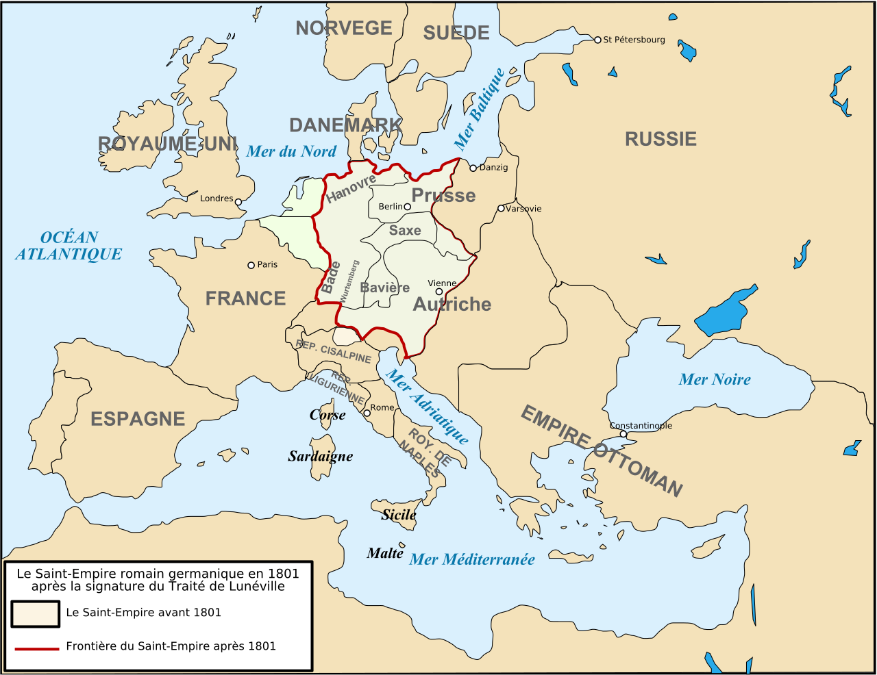
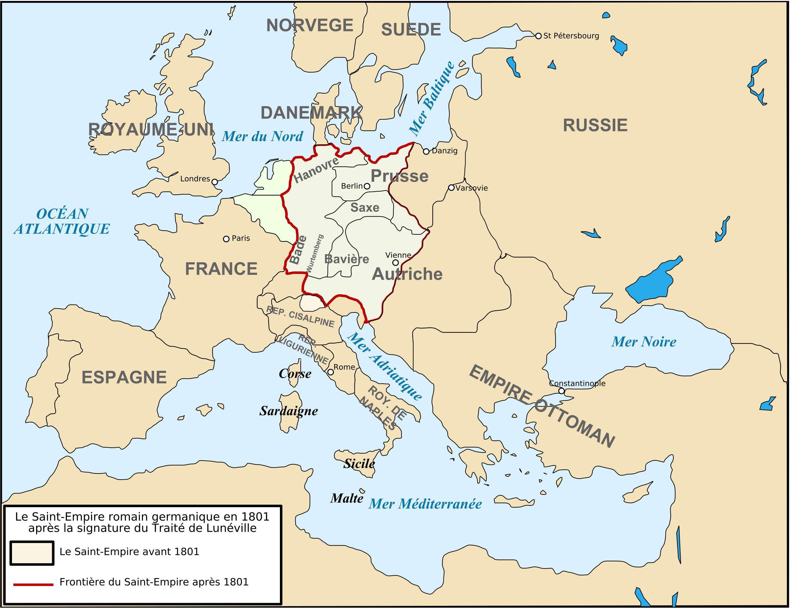
Français : Carte de l'Europe après le traité de Lunéville de 1801. |
| Date | |
| Source | Own work |
| Author | Tinodela |
| Other versions |
  |
Licensing[edit]
I, the copyright holder of this work, hereby publish it under the following licenses:

|
Permission is granted to copy, distribute and/or modify this document under the terms of the GNU Free Documentation License, Version 1.2 or any later version published by the Free Software Foundation; with no Invariant Sections, no Front-Cover Texts, and no Back-Cover Texts. A copy of the license is included in the section entitled GNU Free Documentation License. |
This file is licensed under the Creative Commons Attribution-Share Alike 3.0 Unported, 2.5 Generic, 2.0 Generic and 1.0 Generic license.
- You are free:
- to share – to copy, distribute and transmit the work
- to remix – to adapt the work
- Under the following conditions:
- attribution – You must give appropriate credit, provide a link to the license, and indicate if changes were made. You may do so in any reasonable manner, but not in any way that suggests the licensor endorses you or your use.
- share alike – If you remix, transform, or build upon the material, you must distribute your contributions under the same or compatible license as the original.
You may select the license of your choice.
File history
Click on a date/time to view the file as it appeared at that time.
| Date/Time | Thumbnail | Dimensions | User | Comment | |
|---|---|---|---|---|---|
| current | 07:53, 10 May 2019 | | 1,344 × 1,035 (449 KB) | Isaac Sanolnacov (talk | contribs) | Orthographe : Hanovre ne prend qu'un en français |
| 13:04, 23 August 2008 |  | 1,260 × 970 (584 KB) | Tinodela (talk | contribs) | {{Information |Description= |Source= |Date= |Author= |Permission= |other_versions= }} | |
| 12:51, 23 August 2008 |  | 1,260 × 970 (584 KB) | Tinodela (talk | contribs) | {{Information |Description= |Source= |Date= |Author= |Permission= |other_versions= }} | |
| 12:50, 23 August 2008 |  | 1,260 × 970 (176 KB) | Tinodela (talk | contribs) | {{Information |Description={{fr|1=Carte de l'Europe après le traité de Lunéville de 1801.}} |Source=travail personnel (own work) |Author=Tinodela |Date=23/08/2008 |Permission= |other_versions=[[Image:Strategic Situation of Europe 1801 |
You cannot overwrite this file.
File usage on Commons
The following 3 pages use this file:
File usage on other wikis
The following other wikis use this file:
- Usage on an.wikipedia.org
- Usage on ar.wikipedia.org
- Usage on br.wikipedia.org
- Usage on ca.wikipedia.org
- Usage on cs.wikipedia.org
- Usage on da.wikipedia.org
- Usage on el.wikipedia.org
- Usage on es.wikipedia.org
- Usage on fr.wikipedia.org
- Usage on id.wikipedia.org
- Usage on it.wikipedia.org
- Usage on ka.wikipedia.org
- Usage on lmo.wikipedia.org
- Usage on ms.wikipedia.org
- Usage on nl.wikipedia.org
- Usage on pl.wikipedia.org
- Usage on sv.wikipedia.org
- Usage on tr.wikipedia.org
- Usage on zh.wikipedia.org