File:Safeguarding our oceans (49983713738).jpg
Original file (3,153 × 3,153 pixels, file size: 8.47 MB, MIME type: image/jpeg)
Captions
Captions
Summary
[edit].jpg&action=edit§ion=1)
| Description |
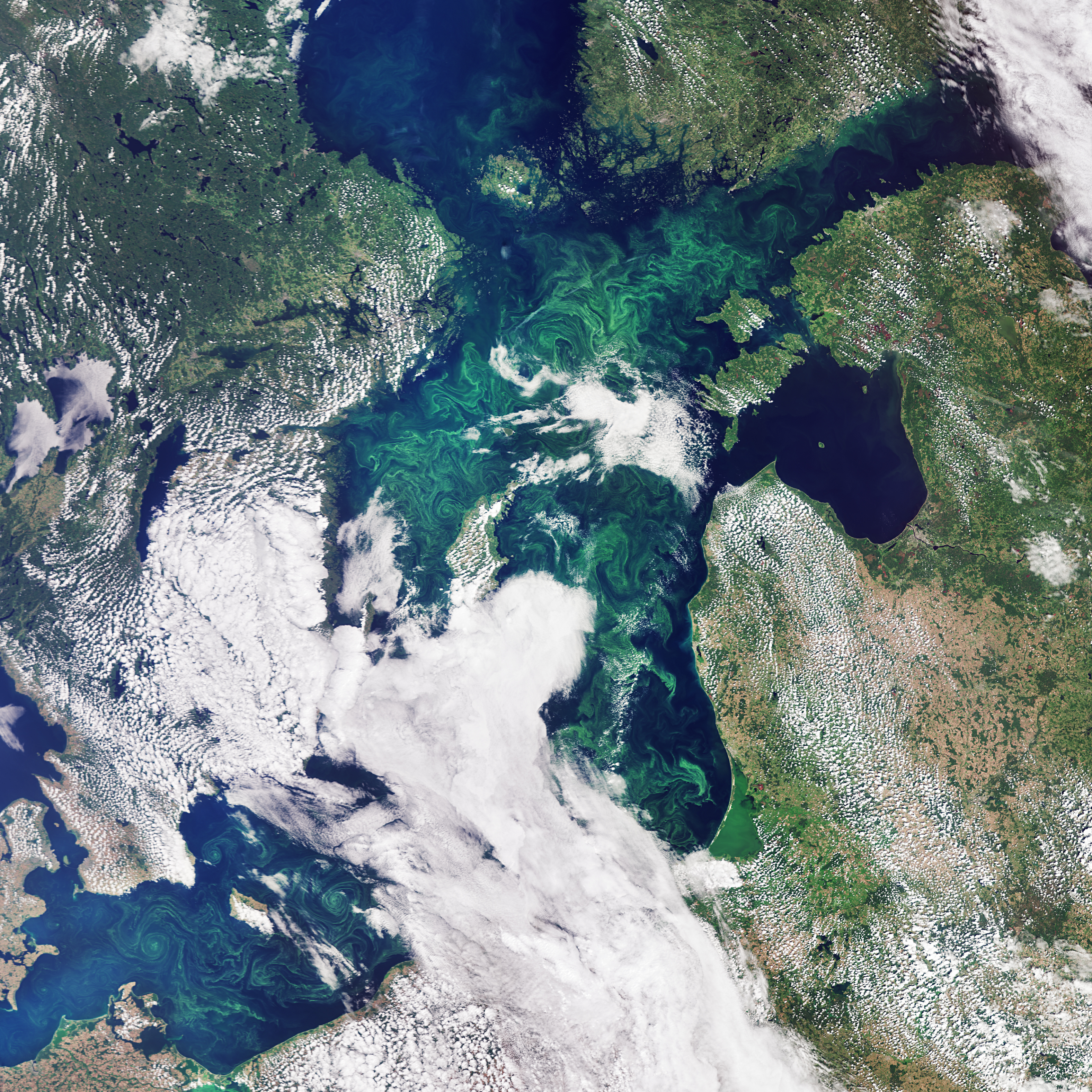
Today marks World Oceans Day, a day that aims to raise awareness in protecting and restoring our oceans and its resources. Today, and every day, Earth observing satellites continuously watch over the ocean to monitor and protect our environment. Covering more than 70% of Earth’s surface, the oceans are what makes this our Blue Planet. Our seas influence the climate, produce the oxygen we breathe, serve as a means of transport and a major source of food and resources. But they are under stress from climate change, pollution and ocean acidification – all of which affect ecosystems and biodiversity. Satellite data increase our scientific understanding and support a range of environmental monitoring services in support of ocean conservation. From water saltiness to wave height, through sea level, sea ice and phytoplankton, satellites take stock of the ocean in many different ways. In this image, captured by the Copernicus Sentinel-3 mission, the green algae blooms swirling around the Baltic Sea are visible. The Baltic Sea faces many serious challenges, including toxic pollutants, deep-water oxygen deficiencies and toxic blooms of cyanobacteria affecting the ecosystem, aquaculture and tourism. Satellite data can track the growth and spread of harmful algae blooms in order to alert and mitigate against damaging impacts for tourism and fishing industries. Learn more about the seas that surround us and how satellite monitoring helps protect them. Credits: contains modified Copernicus Sentinel data (2019), processed by ESA, CC BY-SA 3.0 IGO |
| Date | |
| Source | Safeguarding our oceans |
| Author | European Space Agency |
| Camera location | | View this and other nearby images on: OpenStreetMap |
|---|
.jpg¶ms=058.444858_N_0020.467529_E_globe:Earth_type:camera_source:Flickr_&language=en)
Licensing
[edit].jpg&action=edit§ion=2)
- You are free:
- to share – to copy, distribute and transmit the work
- to remix – to adapt the work
- Under the following conditions:
- attribution – You must give appropriate credit, provide a link to the license, and indicate if changes were made. You may do so in any reasonable manner, but not in any way that suggests the licensor endorses you or your use.
- share alike – If you remix, transform, or build upon the material, you must distribute your contributions under the same or compatible license as the original.
| This image was originally posted to Flickr by europeanspaceagency at https://flickr.com/photos/37472264@N04/49983713738. It was reviewed on 3 December 2020 by FlickreviewR 2 and was confirmed to be licensed under the terms of the cc-by-sa-2.0. |
File history
Click on a date/time to view the file as it appeared at that time.
| Date/Time | Thumbnail | Dimensions | User | Comment | |
|---|---|---|---|---|---|
| current | 15:08, 3 December 2020 | | 3,153 × 3,153 (8.47 MB) | Eyes Roger (talk | contribs) | Transferred from Flickr via #flickr2commons |
You cannot overwrite this file.
File usage on Commons
There are no pages that use this file.
.jpg&oldid=856526144)