File:Romania local administrative units.png
Jump to navigation
Jump to search

Size of this preview: 800 × 513 pixels. Other resolutions: 320 × 205 pixels | 640 × 411 pixels | 1,024 × 657 pixels | 1,280 × 821 pixels.
Original file (1,280 × 821 pixels, file size: 438 KB, MIME type: image/png)
Captions
Captions
Add a one-line explanation of what this file represents
Summary[edit]
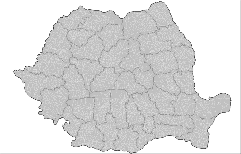
| Description | Map of the local administrative units (municipalities, cities, and communes) of Romania. Created by Rarelibra 17:37, 1 October 2007 (UTC) for public domain use, using MapInfo Professional v8.5 and various mapping resources. |
| Date | 1 October 2007 (original upload date) |
| Source | No machine-readable source provided. Own work assumed (based on copyright claims). |
| Author | No machine-readable author provided. Rarelibra assumed (based on copyright claims). |
Licensing[edit]
| I, the copyright holder of this work, release this work into the public domain. This applies worldwide. In some countries this may not be legally possible; if so: I grant anyone the right to use this work for any purpose, without any conditions, unless such conditions are required by law. |
File history
Click on a date/time to view the file as it appeared at that time.
| Date/Time | Thumbnail | Dimensions | User | Comment | |
|---|---|---|---|---|---|
| current | 10:05, 11 August 2014 | | 1,280 × 821 (438 KB) | Spiridon Ion Cepleanu (talk | contribs) | Little change on Chilia arm (Danube Delta) : meander |
| 17:37, 1 October 2007 |  | 1,601 × 1,027 (134 KB) | Rarelibra (talk | contribs) | Map of the local administrative units (municipalities, cities, and communes) of Romania. Created by ~~~~ for public domain use, using MapInfo Professional v8.5 and various mapping resources. |
You cannot overwrite this file.
File usage on Commons
The following 11 pages use this file:
File usage on other wikis
The following other wikis use this file:
- Usage on ar.wikipedia.org
- Usage on en.wikipedia.org
- Usage on fr.wikipedia.org
- Usage on hu.wikipedia.org
- Usage on it.wikipedia.org
- Usage on ms.wikipedia.org
- Usage on nl.wikipedia.org
- Usage on ro.wikipedia.org
- Usage on sk.wikipedia.org
- Usage on zh.wikipedia.org