File:Romania Judete 1856-1878.jpg
Jump to navigation
Jump to search
Size of this preview: 731 × 599 pixels. Other resolutions: 293 × 240 pixels | 586 × 480 pixels | 937 × 768 pixels | 1,249 × 1,024 pixels.
Original file (1,249 × 1,024 pixels, file size: 518 KB, MIME type: image/jpeg)
Captions
Captions
Add a one-line explanation of what this file represents
Summary[edit]
| Description |
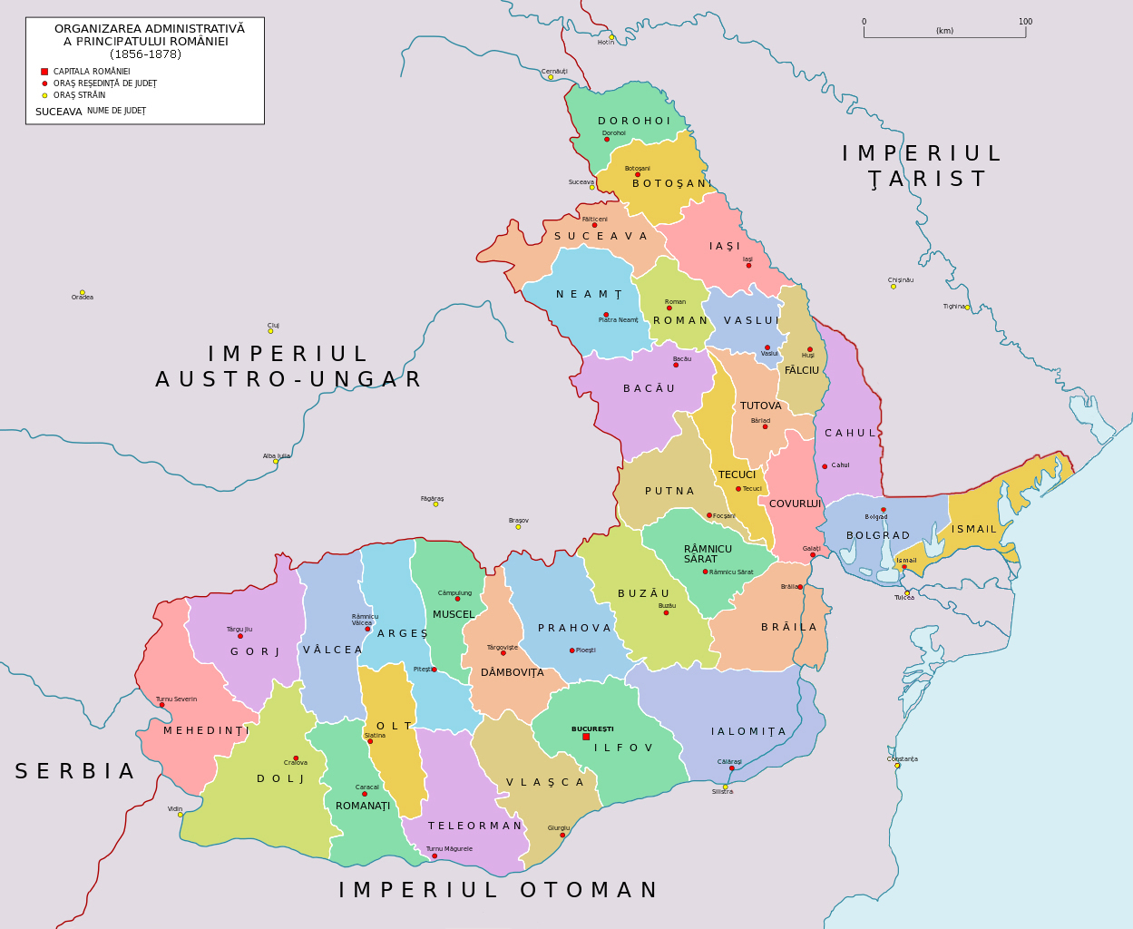
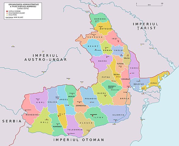
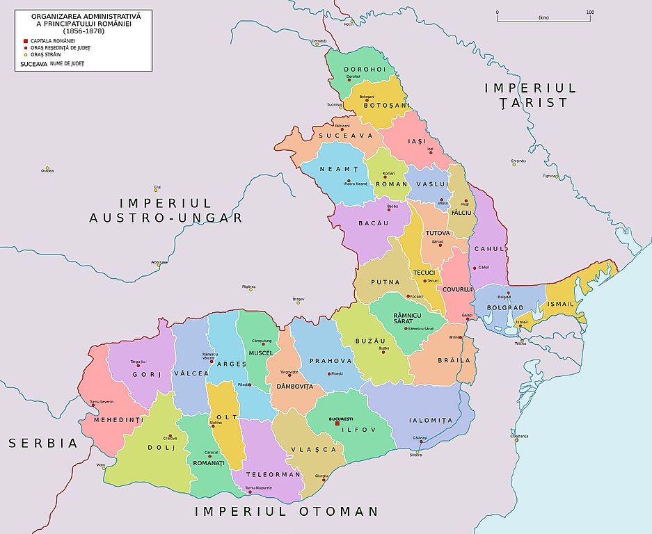
English: Romanian Judetse 1856-1878. |
| Date | |
| Source | Edwart Hertslet, Topographical map of the Turco-Russian Frontier in Bessarabia, in The Map of Europe by Treaty, Chișinău/Kichineff 1867-1875, southern section [1] and C. Brătescu 1944, as well as Spaţiul istoric şi etnic românesc, vol. I, Ed. Militară, Bucharest 1992, maps XV and XVIII, as quoted in Review of Historical Geography and Toponomastics, vol. I, no. 2, 2006, pp. 207-220 |
| Author | Spiridon Ion Cepleanu based on File:Romania si Dacia moderna 1868.JPG and the Arnold Platon's 1878-1913 judetse map |
| Other versions | Anonimu's File:Romania administrative divisions, 1864.svg where Bolgrad/Ismail counties border are partially confused with the reed & salt marsh areas. |
Licensing[edit]
I, the copyright holder of this work, hereby publish it under the following license:
This file is licensed under the Creative Commons Attribution-Share Alike 4.0 International license.
- You are free:
- to share – to copy, distribute and transmit the work
- to remix – to adapt the work
- Under the following conditions:
- attribution – You must give appropriate credit, provide a link to the license, and indicate if changes were made. You may do so in any reasonable manner, but not in any way that suggests the licensor endorses you or your use.
- share alike – If you remix, transform, or build upon the material, you must distribute your contributions under the same or compatible license as the original.
File history
Click on a date/time to view the file as it appeared at that time.
| Date/Time | Thumbnail | Dimensions | User | Comment | |
|---|---|---|---|---|---|
| current | 14:39, 28 December 2019 | | 1,249 × 1,024 (518 KB) | Trecătorul răcit (talk | contribs) | Since Edwart Hertslet, ''Topographical map of the Turco-Russian Frontier in Bessarabia'', Chișinău/Kichineff 1857 in ''The Map of Europe by Treaty'', southern section [http://www.maproom.org/00/02/present.php?m=0019] |
| 17:05, 18 November 2014 |  | 1,249 × 1,024 (515 KB) | Spiridon Ion Cepleanu (talk | contribs) | Colours : contrast | |
| 09:01, 28 September 2014 |  | 1,249 × 1,024 (514 KB) | Spiridon Ion Cepleanu (talk | contribs) | User created page with UploadWizard |
You cannot overwrite this file.
File usage on Commons
The following 4 pages use this file:
File usage on other wikis
The following other wikis use this file:
- Usage on ast.wikipedia.org
- Usage on be.wikipedia.org
- Usage on es.wikipedia.org
- Usage on fr.wikipedia.org
- Usage on ro.wikipedia.org
- Usage on ru.wikipedia.org
- Usage on uk.wikipedia.org
- Usage on www.wikidata.org