File:Rail gauge world.png
Jump to navigation
Jump to search
Size of this preview: 800 × 449 pixels. Other resolutions: 320 × 180 pixels | 640 × 359 pixels | 1,024 × 575 pixels | 1,425 × 800 pixels.
Original file (1,425 × 800 pixels, file size: 49 KB, MIME type: image/png)
Captions
Captions
Add a one-line explanation of what this file represents
Summary
[edit]| Description |
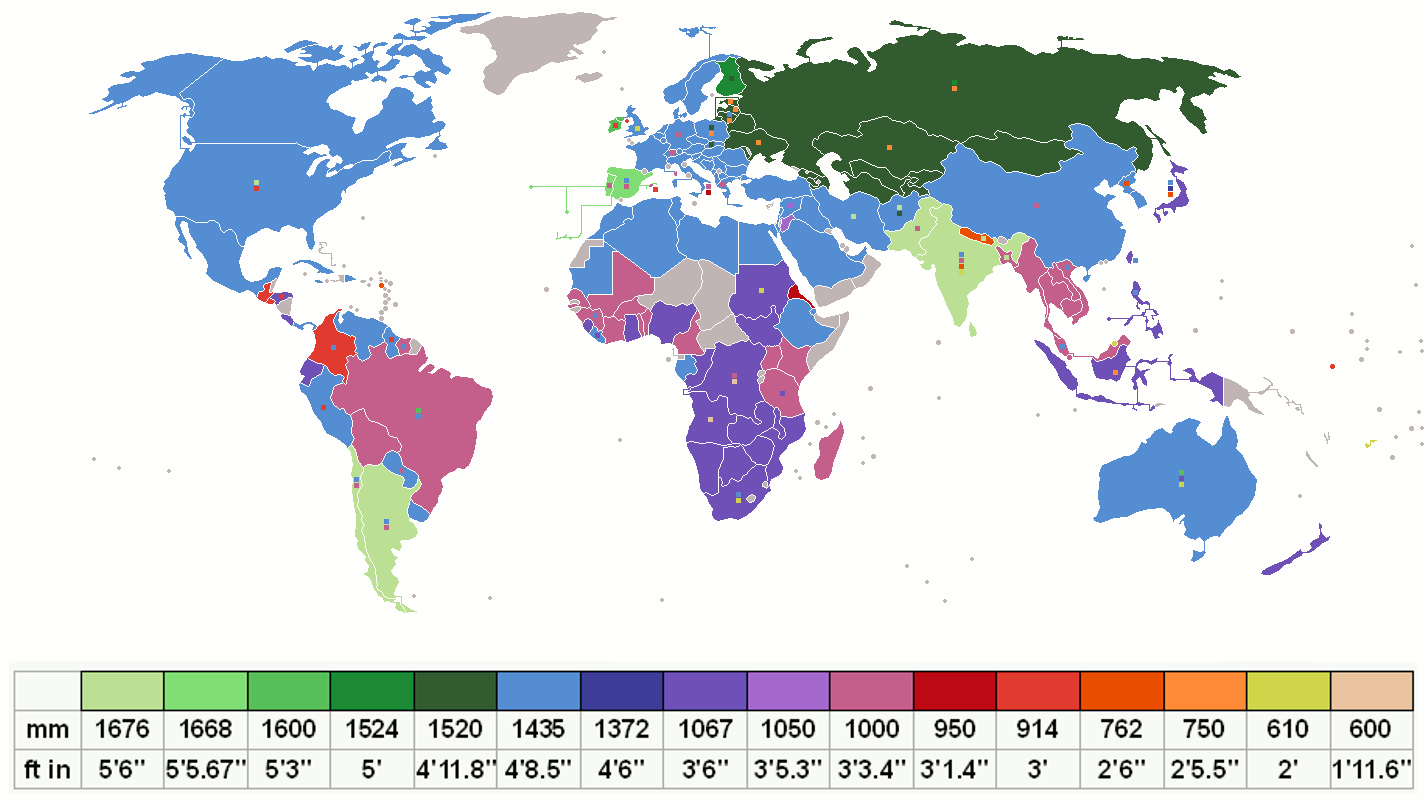
English: Shows the gauge which is currently most used in each country (main colour), with other significant gauges used depicted as small squares on top of the main colour. Grey indicates no railways.
Français : Montre l'écartement le plus utilisé dans chaque pays (couleur principale), les autres écartements significatifs sont illustrés par des petits carrés superposés sur la couleur principale. Le gris signifie pas de chemins de fer.
Español: Muestra la trocha (ancho de vía) más usada en cada país (color principal), con otros calibres significativos como pequeños cuadrados superpuestos sobre el color principal. El color gris indica carencia de ferrocarriles.
中文(简体):显示当前在每个国家/地区最常用的规格(主要颜色),其他重要规格在主要颜色顶部显示为小方块。灰色表示没有铁路。
中文(繁體):顯示當前在每個國家/地區最常用的規格(主要顏色),其他重要規格在主要顏色頂部顯示為小方塊。灰色表示沒有鐵路。 |
|||
| Date | ||||
| Source | Made using the list on CIA Factbook railways and Seabhcan's railmap. Uses File:BlankMap-World-v8.png | |||
| Author | Own work | |||
| Other versions |
File:Rail gauge world with legend.svg - vector version with legend Australian states |


Key
[edit]
.png)
Licensing
[edit]
I, the copyright holder of this work, hereby publish it under the following license:

|
Permission is granted to copy, distribute and/or modify this document under the terms of the GNU Free Documentation License, Version 1.2 or any later version published by the Free Software Foundation; with no Invariant Sections, no Front-Cover Texts, and no Back-Cover Texts. A copy of the license is included in the section entitled GNU Free Documentation License. |
| This file is licensed under the Creative Commons Attribution-Share Alike 3.0 Unported license. | ||
| ||
| This licensing tag was added to this file as part of the GFDL licensing update. |
File history
Click on a date/time to view the file as it appeared at that time.
| Date/Time | Thumbnail | Dimensions | User | Comment | |
|---|---|---|---|---|---|
| current | 21:56, 8 January 2017 | | 1,425 × 800 (49 KB) | Saitek780 (talk | contribs) | Correction of mistake about gauges in Sardinia (which has got both 1435 and 950 mm gauges) |
| 13:42, 20 November 2016 |  | 1,425 × 800 (45 KB) | Metrancya (talk | contribs) | The meter gauge railway line in Ethiopia and Djibouti is out of use. Instead a standard gauge railway has been built between Addis Abeba and Djibouti and opened in 2016. In addition a standard gauge light rail system is in use in Addis. More standard g... | |
| 00:45, 4 October 2016 |  | 1,425 × 800 (45 KB) | Kendall-K1 (talk | contribs) | Paste in a fresh copy of the key, which has developed some resize artifacts | |
| 00:40, 7 May 2016 |  | 1,425 × 800 (52 KB) | Jackdude101 (talk | contribs) | Ignore previous edit. Moved Indian gauge square in US (indicating the BART system in San Francisco) to center of country, to maintain consistent pattern present for all countries on the map. The BART system is the only railway in the US with this tr... | |
| 00:36, 7 May 2016 |  | 1,425 × 800 (52 KB) | Jackdude101 (talk | contribs) | Moved Indian gauge square in US (indicating the BART system in San Francisco) to center of country, to maintain consistent pattern present for all countries on the map. The BART system is the only railway in the US with this track gauge, but whatever. | |
| 09:12, 23 November 2015 |  | 1,425 × 800 (51 KB) | Trotting cove (talk | contribs) | tidy up legend by removing redundant border line | |
| 10:22, 24 February 2015 |  | 1,425 × 800 (26 KB) | Mjdestroyerofworlds (talk | contribs) | BART | |
| 10:17, 24 February 2015 |  | 1,425 × 800 (26 KB) | Mjdestroyerofworlds (talk | contribs) | Reverted to version as of 17:39, 7 March 2014 | |
| 10:17, 24 February 2015 |  | 1,425 × 800 (26 KB) | Mjdestroyerofworlds (talk | contribs) | BART | |
| 17:39, 7 March 2014 |  | 1,425 × 800 (26 KB) | Kopiersperre (talk | contribs) | optipng |
You cannot overwrite this file.
File usage on Commons
The following 23 pages use this file:
- Track gauge sizes
- User:Chumwa/OgreBot/Potential transport maps/2016 May 1-10
- User:Chumwa/OgreBot/Potential transport maps/2016 November 11-20
- User:Chumwa/OgreBot/Potential transport maps/2016 October 1-10
- User:Chumwa/OgreBot/Potential transport maps/2017 January 1-10
- User:Chumwa/OgreBot/Public transport information/2015 February 19-28
- User:Chumwa/OgreBot/Public transport information/2015 November 21-30
- User:Chumwa/OgreBot/Public transport information/2016 May 1-10
- User:Chumwa/OgreBot/Public transport information/2016 November 11-20
- User:Chumwa/OgreBot/Public transport information/2016 October 1-10
- User:Chumwa/OgreBot/Public transport information/2017 January 1-10
- User:Chumwa/OgreBot/Transport Maps/2015 February 19-28
- User:Chumwa/OgreBot/Transport Maps/2015 November 21-30
- User:Chumwa/OgreBot/Transport Maps/2016 May 1-10
- User:Chumwa/OgreBot/Transport Maps/2016 November 11-20
- User:Chumwa/OgreBot/Transport Maps/2016 October 1-10
- User:Chumwa/OgreBot/Transport Maps/2017 January 1-10
- User:Chumwa/OgreBot/Travel and communication maps/2016 May 1-10
- User:Chumwa/OgreBot/Travel and communication maps/2016 November 11-20
- User:Chumwa/OgreBot/Travel and communication maps/2016 October 1-10
- User:Chumwa/OgreBot/Travel and communication maps/2017 January 1-10
- User:Frettiebot/Galleries/Jklamo/2007/10
- User:Liesel/Rail transport/2015 February 19-28
File usage on other wikis
The following other wikis use this file:
- Usage on als.wikipedia.org
- Usage on ar.wikipedia.org
- Usage on bg.wikipedia.org
- Usage on bh.wikipedia.org
- Usage on ca.wikipedia.org
- Usage on cs.wikipedia.org
- Usage on cy.wikipedia.org
- Usage on da.wikipedia.org
- Usage on de.wikipedia.org
- Usage on el.wikipedia.org
- Usage on en.wikipedia.org
- Usage on eo.wikipedia.org
- Usage on es.wikipedia.org
- Ancho de vía
- Ancho ibérico
- Ferrocarril de vía estrecha
- Great Western Railway
- Ancho métrico
- Ancho internacional
- Plantilla:Barra lateral ancho de vía
- Plantilla:Barra lateral ancho de vía/doc
- Ancho ruso
- Ferrocarril de vía ancha
- Breitspurbahn
- Anexo:Sistemas de tranvías por ancho de vía y electrificación
- Ancho indio
- Ancho irlandés
- Ancho escocés
- Ancho del Cabo
- Ancho de tres pies
- Ancho de tres pies suecos
- Ancho imperial
- Ancho bosnio
- Anchos de 2 pies y de 600 mm
- Vía Decauville
- Ancho de quince pulgadas
- Anexo:Sistemas de metro por ancho de vía
- Conversión de ancho de vía
View more global usage of this file.