File:Punto di livello altimetrico dell'IGM.jpg
Jump to navigation
Jump to search

Size of this preview: 800 × 598 pixels. Other resolutions: 320 × 239 pixels | 640 × 478 pixels | 1,024 × 765 pixels | 1,280 × 956 pixels | 2,592 × 1,936 pixels.
Original file (2,592 × 1,936 pixels, file size: 2.49 MB, MIME type: image/jpeg)
Captions
Captions
Add a one-line explanation of what this file represents
Summary[edit]
| Description | |
| Date | |
| Source |
Own work
|
| Author | OppidumNissenae |
| Camera location | | View this and other nearby images on: OpenStreetMap |
|---|
Licensing[edit]
I, the copyright holder of this work, hereby publish it under the following license:
This file is licensed under the Creative Commons Attribution-Share Alike 4.0 International license.
- You are free:
- to share – to copy, distribute and transmit the work
- to remix – to adapt the work
- Under the following conditions:
- attribution – You must give appropriate credit, provide a link to the license, and indicate if changes were made. You may do so in any reasonable manner, but not in any way that suggests the licensor endorses you or your use.
- share alike – If you remix, transform, or build upon the material, you must distribute your contributions under the same or compatible license as the original.

|
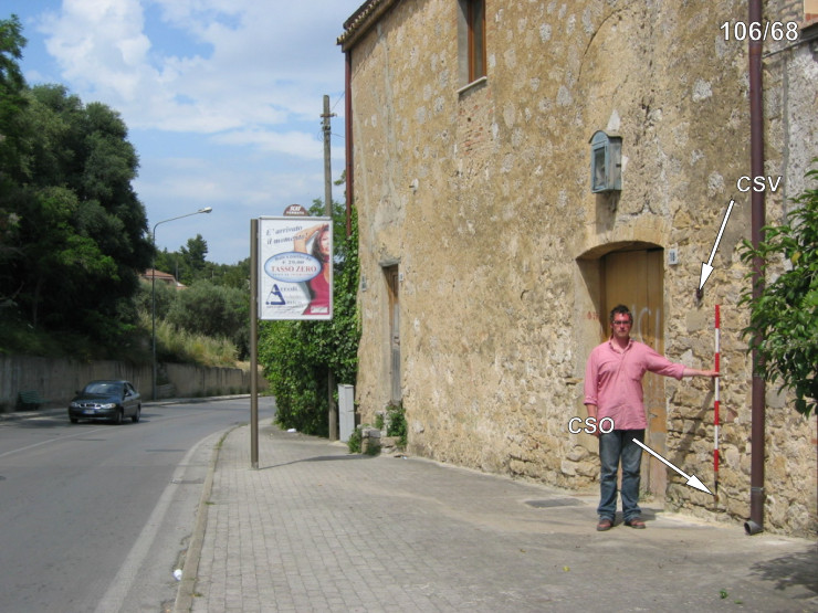
This image has been assessed under the valued image criteria and is considered the most valued image on Commons within the scope: Benchmarks of Istituto Geografico Militare - The only CAPOSALDO DI LIVELLAZIONE of Istituto Geografico Militare. You can see its nomination here. |
File history
Click on a date/time to view the file as it appeared at that time.
| Date/Time | Thumbnail | Dimensions | User | Comment | |
|---|---|---|---|---|---|
| current | 11:37, 8 May 2018 | | 2,592 × 1,936 (2.49 MB) | OppidumNissenae (talk | contribs) | User created page with UploadWizard |
You cannot overwrite this file.
File usage on Commons
The following 7 pages use this file:
- Trig points and benchmarks
- User:OppidumNissenae
- User talk:OppidumNissenae
- Commons:Photo challenge/2018 - May - Architectural iron
- Commons:Photo challenge/2018 - May - Architectural iron/Voting
- Commons:Photo challenge/2018 - May - Architectural iron/Voting/Result
- Commons:Valued image candidates/Punto di livello altimetrico dell'IGM.jpg
File usage on other wikis
The following other wikis use this file:
- Usage on it.wikipedia.org