File:Political map Afar triangle.png
Political_map_Afar_triangle.png (373 × 454 pixels, file size: 436 KB, MIME type: image/png)
Captions
Captions
Afar Triangle Democratic Republic
Afar Triangle Democratic Republic
- Capital:- Samara
- Largest city:- Djibouti
- Official languages:- Afar Af
- Official Constitution:-
Traditional Law of Afar
- National languages[d]
Afar Af
- Language:-
Kushtic Language
- Ethnic groups (2016)[12]
Kush
- Religion (2022):-
98.5% Muslim
1.5% Christianity
0.5% Others
- Demonym(s):-
Afar
- Rolling Party:-
- Head of Party:-
Essie Adem Essie
- Government:-
Afar Triangle Democratic republic
• President:- Awal Arba
• Vice President:- Elama Abubaker
- Area:-
• Total 189,000Km2
- Population:-
• August 2022 estimate 7,268,567
- Currency:-
Ethiopian Birr (Etb$) (Halko)
- Time zone:-
UTC+8 (East Africa Time)
- Date format:-
DDD-MM-YY (East Africa)
- Driving side:-
Left
- Calling code:-
+251
Edited by M.d Hakena Sugnie
Environment Edit
Summary
[edit]| Description |
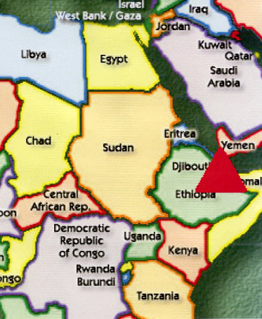
English: Political map of the Afar Triangle Democratic Republic State. See : Second Afar insurency (1995–present) |
||||
| Date | |||||
| Source | Own work | ||||
| Author | Razashah1 | ||||
| Other versions |
|


.svg)


.svg)


.svg)


_Territory_Change_2014-2016.gif)

_(within_Northern_Syria).svg)


.png)
.svg)


_map.png)
.svg)


.svg)


Afar Triangle Democratic Republic
- Capital:- Samara
- Largest city:- Djibouti
- Official languages:- Afar Af
- Official script
- Traditional Afar[8]
- National languages[d]
Afar Af
- Language:-
Afar Af Language
- Ethnic groups (2016)[12]
Kush
- Religion (2022):-
- 98.5% Muslim
- 1.5% Christianity
- "0.5% Others
- Demonym(s):-
Afar[14]
- Rolling Party:-
Afar Prosperity Party
- Head of Party:-
Essie Adem Essie
- Government:-
Afar Triangle Democratic republic
• President:- Awal Arba
• Vice President:- Elama Abubaker
Area:- • Total 189,000Km2
Population:- • August 2022 estimate 7,268,567
- Currency:-
Ethiopian Birr (Etb$) (Halko)
- Time zone:-
UTC+8 (East Africa Time)
- Date format:-
DDD-MM-YY (East Africa)
- Driving side:-
Left
- Calling code:-
+251
Edited by M.d Hakena Sugnie
Environment Edit
Licensing
[edit]
- You are free:
- to share – to copy, distribute and transmit the work
- to remix – to adapt the work
- Under the following conditions:
- attribution – You must give appropriate credit, provide a link to the license, and indicate if changes were made. You may do so in any reasonable manner, but not in any way that suggests the licensor endorses you or your use.
File history
Click on a date/time to view the file as it appeared at that time.
| Date/Time | Thumbnail | Dimensions | User | Comment | |
|---|---|---|---|---|---|
| current | 18:02, 4 December 2010 | | 373 × 454 (436 KB) | Razashah1 (talk | contribs) | {{Information |Description={{en|1=Political map of the Afar Triangle region}} |Source={{own}} |Author=Razashah1 |Date=2010-12-04 |Permission= |other_versions= }} Category:Maps |
You cannot overwrite this file.
File usage on Commons
There are no pages that use this file.