File:Pizzigano.jpg
Jump to navigation
Jump to search
Size of this preview: 800 × 505 pixels. Other resolutions: 320 × 202 pixels | 640 × 404 pixels | 1,024 × 646 pixels | 1,280 × 808 pixels | 2,560 × 1,616 pixels | 4,360 × 2,752 pixels.
Original file (4,360 × 2,752 pixels, file size: 3.35 MB, MIME type: image/jpeg)
Captions
Captions
Add a one-line explanation of what this file represents
Summary[edit]
| Description |
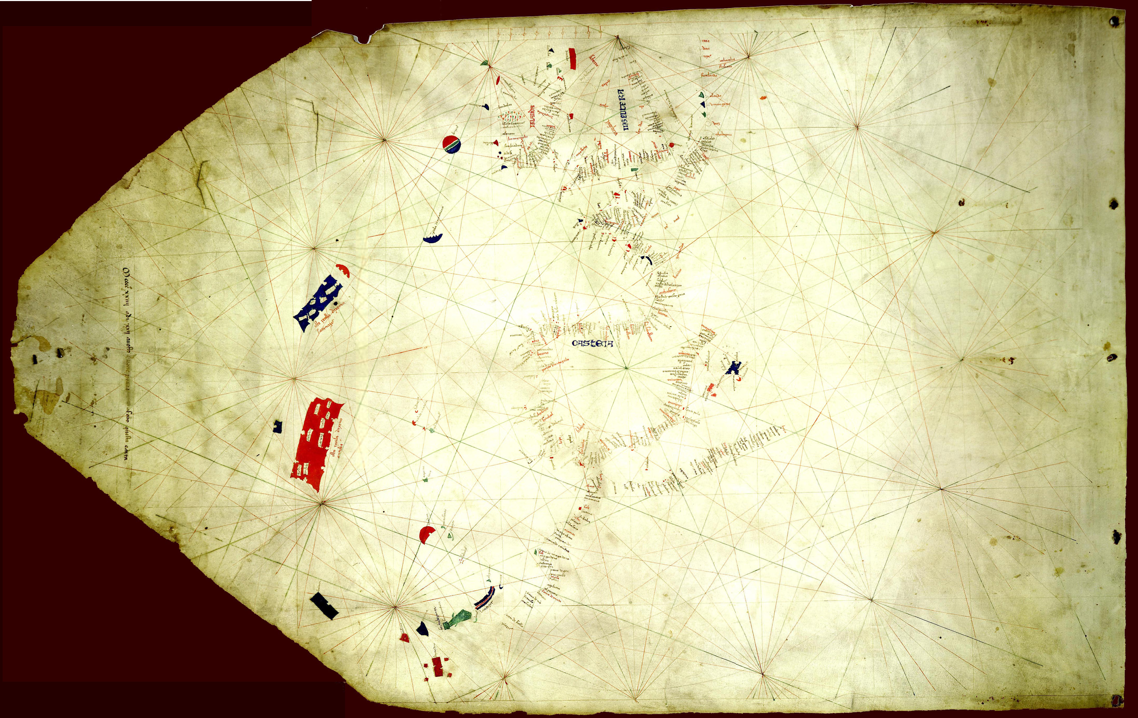
English: The Pizzigano map, also known as the Pizzigano chart is an Italian portolan chart dated 1424. It contains islands in the North Atlantic Ocean in the west of Spain and Portugal including Portuguese discoveries and legendary islands such as Antillia. The cartographer may have been the Venetian Zuane Pizigano, possibly a descendant of a 14th century family of mapmakes one of whom authored another well known map also called the Pizziagano map in Parma in 1367 |
| Date | |
| Source | University of Minnesota Libraries 8 gemonteerde screenshots. Own work |
| Author | Pizzigiano, Zuane & XpoferenS |
| Other versions | Derivative works of this file: Pizzigano 1424 map (Antilia islands detail).JPG |
.JPG)
Licensing[edit]
| I, the copyright holder of this work, release this work into the public domain. This applies worldwide. In some countries this may not be legally possible; if so: I grant anyone the right to use this work for any purpose, without any conditions, unless such conditions are required by law. |
File history
Click on a date/time to view the file as it appeared at that time.
| Date/Time | Thumbnail | Dimensions | User | Comment | |
|---|---|---|---|---|---|
| current | 09:37, 20 November 2014 | | 4,360 × 2,752 (3.35 MB) | Joop Rotte (talk | contribs) | Meer detail door hogere resolutie |
| 14:39, 9 June 2011 |  | 1,140 × 725 (190 KB) | Walrasiad (talk | contribs) | Larger version of 1424 Pizzigano chart | |
| 20:14, 30 May 2009 |  | 500 × 318 (34 KB) | XpoferenS (talk | contribs) | {{Information |Description={{en|1=The Pizzigano map, also known as the Pizzigano chart is an Italian portolan chart dated 1424. It contains islands in the North Atlantic Ocean in the west of Spain and Portugal including Portuguese discoveries and legendar |
You cannot overwrite this file.
File usage on Commons
The following 2 pages use this file:
File usage on other wikis
The following other wikis use this file:
- Usage on ca.wikipedia.org
- Usage on de.wikipedia.org
- Usage on en.wikipedia.org
- Usage on es.wikipedia.org
- Usage on fr.wikipedia.org
- Usage on it.wikipedia.org
- Usage on ja.wikipedia.org
- Usage on pt.wikipedia.org
- Usage on ru.wikipedia.org
- Usage on uk.wikipedia.org
- Usage on www.wikidata.org