File:Panstwo mieclawa.svg
Jump to navigation
Jump to search

Size of this PNG preview of this SVG file: 700 × 567 pixels. Other resolutions: 296 × 240 pixels | 593 × 480 pixels | 948 × 768 pixels | 1,264 × 1,024 pixels | 2,529 × 2,048 pixels.
Original file (SVG file, nominally 700 × 567 pixels, file size: 3.3 MB)
Captions
Captions
Add a one-line explanation of what this file represents
Summary[edit]
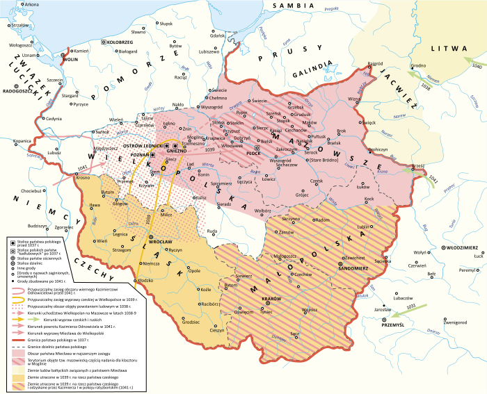
| Description |
Polski: Państwo Miecława oraz granice Polski w 1037 roku |
| Date | |
| Source |
Own work Book source: Janusz Bieniak Państwo Miecława. Studium Analityczne, PWN, 2012 |
| Author | Hoodinski |
| Other versions |

Licensing[edit]
I, the copyright holder of this work, hereby publish it under the following license:
This file is licensed under the Creative Commons Attribution-Share Alike 3.0 Unported license.
- You are free:
- to share – to copy, distribute and transmit the work
- to remix – to adapt the work
- Under the following conditions:
- attribution – You must give appropriate credit, provide a link to the license, and indicate if changes were made. You may do so in any reasonable manner, but not in any way that suggests the licensor endorses you or your use.
- share alike – If you remix, transform, or build upon the material, you must distribute your contributions under the same or compatible license as the original.
File history
Click on a date/time to view the file as it appeared at that time.
| Date/Time | Thumbnail | Dimensions | User | Comment | |
|---|---|---|---|---|---|
| current | 18:32, 11 February 2024 | | 700 × 567 (3.3 MB) | +JMJ+ (talk | contribs) | Reverted to version as of 21:38, 18 December 2023 (UTC) - "jotvingiai iki 12–13 a. pietuose gyvenę iki Bugo upės (Brastos-Drohičino apylinkėse)" (https://www.vle.lt/straipsnis/jotvingiai/). "until the 12th-13th centuries, Yotvingians lived in the south up to the Bug river (in the vicinity of Lithuanian Brest-Drohiczyn)". Yotvingian borders are ahistorically minimalized in this map and inaccurately depicted as part of Poland despite that not being the case. |
| 17:24, 7 February 2024 |  | 700 × 567 (3.21 MB) | Bornholm (talk | contribs) | Reverted to version as of 21:43, 25 November 2023 (UTC) The Yotvingians did not live further south than the course of the Narew rivers. This is confirmed archaeologically. There are also no reliable historical sources that confirm settlements south of this river. South of this river there are no traces of their settlement or other Baltic tribes. Invasions to the south were only robbery and never had a settlement character. | |
| 21:38, 18 December 2023 |  | 700 × 567 (3.3 MB) | +JMJ+ (talk | contribs) | Reverted to version as of 16:12, 28 August 2023 (UTC) - revert to historically accurate version | |
| 21:43, 25 November 2023 |  | 700 × 567 (3.21 MB) | Kamilhrub (talk | contribs) | Reverted to version as of 10:48, 22 May 2023 (UTC) as in book source | |
| 16:12, 28 August 2023 |  | 700 × 567 (3.3 MB) | +JMJ+ (talk | contribs) | Reverted to version as of 10:07, 16 May 2023 (UTC) - https://www.vle.lt/straipsnis/jotvingiai/ says that "the Jotvingians lived in the south up to the Bug river (in the vicinity of Brasta-Drohičin) until the 12th-13th century." | |
| 10:48, 22 May 2023 |  | 700 × 567 (3.21 MB) | Bornholm (talk | contribs) | Reverted to version as of 14:43, 27 March 2023 (UTC) The Yotvingians did not live further south than the course of the Narew rivers. This is confirmed archaeologically. There are also no reliable historical sources that confirm settlements south of this river. South of this river there are no traces of their settlement or other Baltic tribes. Invasions to the south were only robbery and never had a settlement character. | |
| 10:07, 16 May 2023 |  | 700 × 567 (3.3 MB) | +JMJ+ (talk | contribs) | Reverted to version as of 07:52, 25 February 2023 (UTC) Yotvingians were indeed inhabiting that far south - they were fighting for their native lands there against various Slavs (including the Poles) still in the 12th century | |
| 14:43, 27 March 2023 |  | 700 × 567 (3.21 MB) | Bornholm (talk | contribs) | Correction of the Polish border with Yotvingians. Yotvingian tribes never had settlements so far south and never reached the Bug river. | |
| 07:52, 25 February 2023 |  | 700 × 567 (3.3 MB) | ZxcvU (talk | contribs) | Przemysl was under Kyivan Rus' control since Yaroslav's March on Poland in 1031 | |
| 16:18, 17 February 2023 |  | 700 × 567 (3.29 MB) | +JMJ+ (talk | contribs) | Corrections of Poland's eastern borders. Yotvingia was far larger at the time. |
You cannot overwrite this file.
File usage on Commons
The following 11 pages use this file:
- User:Hoodinski
- User:Magog the Ogre/Multilingual legend/2023 August 27-31
- User:Magog the Ogre/Multilingual legend/2023 December 17-21
- User:Magog the Ogre/Multilingual legend/2023 February 10-18
- User:Magog the Ogre/Multilingual legend/2023 February 19-28
- User:Magog the Ogre/Multilingual legend/2023 March 21-31
- User:Magog the Ogre/Multilingual legend/2023 May 11-20
- User:Magog the Ogre/Multilingual legend/2023 May 21-31
- User:Magog the Ogre/Multilingual legend/2024 February 10-14
- User:Magog the Ogre/Multilingual legend/2024 February 5-9
- File:Panstwo mieclawa-es.svg
File usage on other wikis
The following other wikis use this file:
- Usage on de.wikipedia.org
- Usage on en.wikipedia.org
- Usage on ja.wikipedia.org
- Usage on mt.wikipedia.org
- Usage on pl.wikipedia.org
- Kazimierz I Odnowiciel
- Mazowsze
- Polska wczesnopiastowska
- Mazury
- Miecław
- Bitwa Kazimierza I z Miecławem
- Powstanie ludowe w Polsce
- Reakcja pogańska
- Historia Polski (do 1138)
- Wikipedysta:Hoodinski
- Układ ratyzboński
- Najazd Brzetysława
- Państwo Miecława
- Wikipedysta:Luki1223/brudnopis
- Wikipedysta:Malarz pl/szablony/Państwo infobox
- Wikipedysta:Malarz pl/szablony/Państwo infobox/27
- Usage on ru.wikipedia.org
- Usage on sl.wikipedia.org
- Usage on sv.wikipedia.org
- Usage on uk.wikipedia.org
- Usage on www.wikidata.org
Metadata
Categories:
- Maps of the Kingdom of Poland (Piasts)
- SVG maps of the history of Belarus
- Maps of Balts
- Maps of Silesia
- Maps of the history of Bohemia and Moravia
- Maps of the military history of Poland
- Maps showing 11th-century history
- Territorial evolution of Poland
- SVG maps of the history of Poland
- Polish-language SVG maps showing history