File:Old Dniper.jpg
Jump to navigation
Jump to search

Size of this preview: 276 × 599 pixels. Other resolutions: 110 × 240 pixels | 221 × 480 pixels | 353 × 768 pixels | 471 × 1,024 pixels | 943 × 2,048 pixels | 3,023 × 6,563 pixels.
Original file (3,023 × 6,563 pixels, file size: 2.06 MB, MIME type: image/jpeg)
Captions
Captions
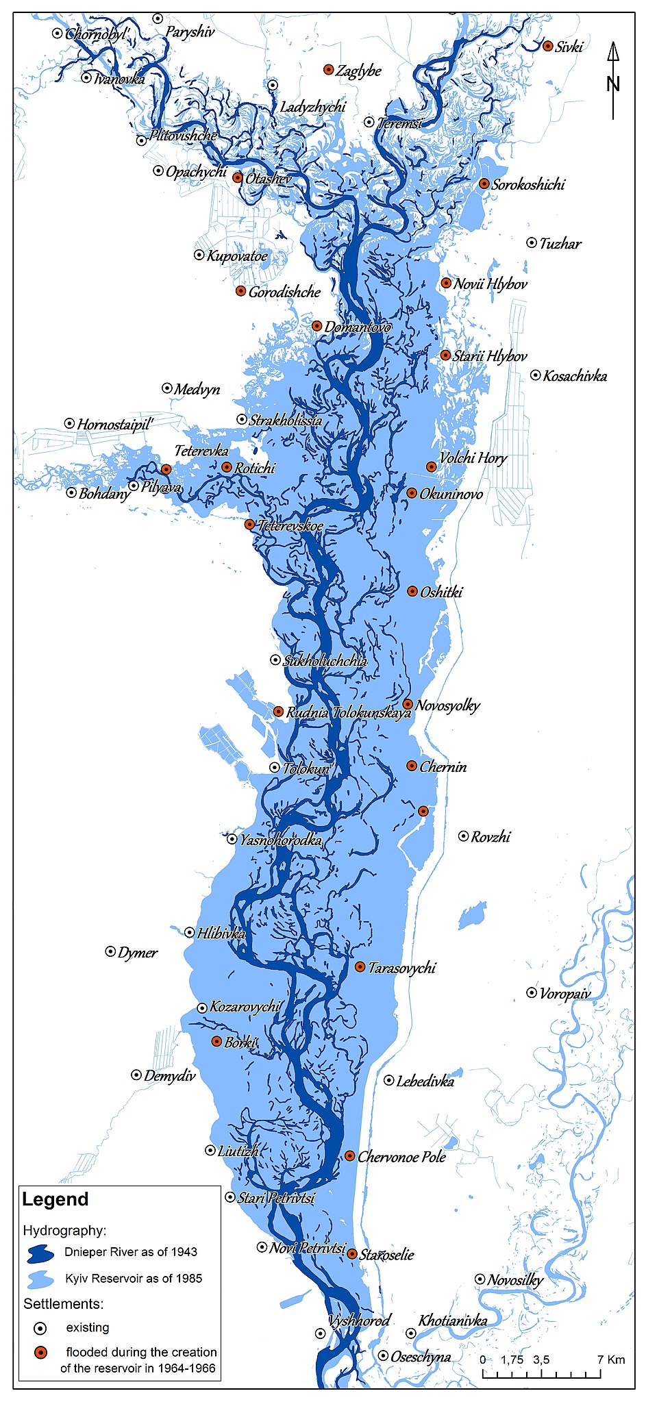
Map of the reconstruction of the old Dnipro
Summary
[edit]
| Description |
Українська: Карта реконструкції старого русла Дніпра дозволила відтворити історичний вигляд річки до побудови каскаду ГЕС та водосховищ. Із русла Дніпра, яке протікає територією України, в природному стані збереглося лише 100 км з 2 285 км, решта - зарегульована каскадом дніпровських водосховищ. Київське водосховище, введене в експлуатацію в 1964 р., внесло відчутні зміни у природні умови краю, зокрема було відселено та затоплено більше 20 сіл. Для створення цієї карти Дніпра в межах Київського водосховища були використані історичні топографічні карти місцевості 1942 р. та архівні космічні знімки 1985 р.
English: Map of the reconstruction of the old Dnipro riverbed allowed to recreate the historical river view before the construction of the hydroelectric power station and reservoirs. Only 100 km out of 2 285 km have been preserved in the natural state from the Dnipro bed, which flows through the territory of Ukraine, the rest is regulated by the cascade of the Dnipro reservoirs. The Kiev reservoir, which was put into operation in 1964, made significant changes to the natural conditions of the region, in particular more than 20 villages were displaced and flooded. Historical topographic maps of the area in 1942 and archival space images of 1985 were used to create this map of the Dnipro within the Kyiv reservoir. English: Map of the old Dnipro |
| Date | |
| Source | Own work |
| Author | Tomchenko Olha |
Licensing
[edit]
I, the copyright holder of this work, hereby publish it under the following license:
This file is licensed under the Creative Commons Attribution 4.0 International license.
- You are free:
- to share – to copy, distribute and transmit the work
- to remix – to adapt the work
- Under the following conditions:
- attribution – You must give appropriate credit, provide a link to the license, and indicate if changes were made. You may do so in any reasonable manner, but not in any way that suggests the licensor endorses you or your use.
| This image was uploaded as part of Wiki Science Competition 2019. |
File history
Click on a date/time to view the file as it appeared at that time.
| Date/Time | Thumbnail | Dimensions | User | Comment | |
|---|---|---|---|---|---|
| current | 22:47, 25 November 2019 | | 3,023 × 6,563 (2.06 MB) | Tomch olha (talk | contribs) | User created page with UploadWizard |
You cannot overwrite this file.
File usage on Commons
There are no pages that use this file.