File:North Atlantic seafloor with text.jpg

Original file (14,170 × 10,501 pixels, file size: 20.53 MB, MIME type: image/jpeg)
Captions
Captions
Summary[edit]
| Warning | The original file is very high-resolution. It might not load properly or could cause your browser to freeze when opened at full size. |
|---|
| Description |
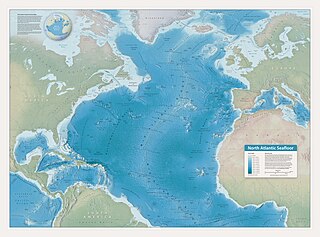
English: A topological map of the North Atlantic Ocean, depicting undersea features, by Tom Patterson (shadedrelief.com), from an edited version of the General Bathymetric Chart of the Oceans. This version of the map has labels and other text.
Description from the map: "Blue Earth Bathymetry is the source of all topography shown on the map. It is an edited version of the GEBCO (General Bathymetric Chart of the Oceans) dataset. The 3D topography, rendered as plan oblique relief, depicts undersea features in partial profile with 1,100 percent vertical exaggeration. South-facing slopes receive more emphasis than steep slopes facing north, some of which disappear from view. The Northwest Atlantic Mid-Ocean Channel and the Maury Channel received manual touchups. Mapped terrestrial areas derive from Natural Earth vector and raster data. The GEBCO Gazetteer of Undersea Feature Names was the source for ocean bottom labels. Note that the map graticule represents sea level; the latitude of seafloor features is slightly less and varies depending on the depth. Cartography by Tom Patterson, v. 1.0, July 29, 2020. For information about the map and to download it, visit: www.shadedrelief.com/atlantic Natural Earth projection, central meridian 40° W" |
||
| Date | |||
| Source | http://www.shadedrelief.com/atlantic/ | ||
| Author | Tom Patterson | ||
| Permission (Reusing this file) |
|
||
| Other versions | File:North Atlantic seafloor.jpg |
Licensing[edit]
| This work has been released into the public domain by its author, Tom Patterson. This applies worldwide. In some countries this may not be legally possible; if so: Tom Patterson grants anyone the right to use this work for any purpose, without any conditions, unless such conditions are required by law.
|
"The North Atlantic Seafloor map is in the public domain. You may use it any way that you want."
File history
Click on a date/time to view the file as it appeared at that time.
| Date/Time | Thumbnail | Dimensions | User | Comment | |
|---|---|---|---|---|---|
| current | 00:22, 27 September 2021 | | 14,170 × 10,501 (20.53 MB) | Eviolite (talk | contribs) | Uploaded a work by Tom Patterson from http://www.shadedrelief.com/atlantic/ with UploadWizard |
You cannot overwrite this file.
File usage on Commons
The following page uses this file:
- File:North-Atlantic-Map-Type.jpg (file redirect)