File:Nagorno Karabakh03.png
Jump to navigation
Jump to search

Size of this preview: 418 × 600 pixels. Other resolutions: 167 × 240 pixels | 334 × 480 pixels | 988 × 1,418 pixels.
Original file (988 × 1,418 pixels, file size: 50 KB, MIME type: image/png)
Captions
Captions
Add a one-line explanation of what this file represents
Summary[edit]
| Description |
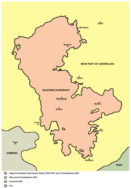
English: Nagorno-Karabakh Autonomous Oblast map. |
| Date | |
| Source | Own work |
| Author | user:PANONIAN |

|
This map has been uploaded by Electionworld from en.wikipedia.org to enable the |
| I, the copyright holder of this work, release this work into the public domain. This applies worldwide. In some countries this may not be legally possible; if so: I grant anyone the right to use this work for any purpose, without any conditions, unless such conditions are required by law. |
References[edit]
- http://www.karabakh.org/wp-content/uploads/2011/09/nagorno-karabakh.gif
- http://www.halotrust.org/Library/images/page_images/full_width/738_nagorno_karabakh.jpg
- http://www.acig.org/artman/uploads/map_nagorniy_karabakh.jpg
- http://sumgait.info/img/ethnic-cleansing-in-progress/nkr.gif
- http://1.bp.blogspot.com/-ykHF0dWo72U/TXwe8zLvO0I/AAAAAAAAAAM/UJlJxfMvxWg/s1600/nagornkarabah-1.gif
File history
Click on a date/time to view the file as it appeared at that time.
| Date/Time | Thumbnail | Dimensions | User | Comment | |
|---|---|---|---|---|---|
| current | 16:51, 13 December 2023 | | 988 × 1,418 (50 KB) | Josemite (talk | contribs) | Reverted to version as of 19:29, 3 October 2020 (UTC) |
| 05:53, 10 December 2020 |  | 793 × 971 (30 KB) | Nicolay Sidorov (talk | contribs) | ... | |
| 05:51, 10 December 2020 |  | 793 × 971 (34 KB) | Nicolay Sidorov (talk | contribs) | new | |
| 19:29, 3 October 2020 |  | 988 × 1,418 (50 KB) | Nicolay Sidorov (talk | contribs) | ooops! cities labels are forgot.. | |
| 19:22, 3 October 2020 |  | 988 × 1,418 (48 KB) | Nicolay Sidorov (talk | contribs) | fully fixed borders (1988 actual) | |
| 09:58, 29 April 2014 |  | 988 × 1,418 (66 KB) | PANONIAN (talk | contribs) | aesthetics | |
| 17:10, 25 June 2012 |  | 1,017 × 1,433 (66 KB) | PANONIAN (talk | contribs) | improved my own work | |
| 19:51, 19 December 2006 |  | 898 × 1,112 (39 KB) | Electionworld (talk | contribs) | {{ew|en|PANONIAN}} Nagorno-Karabakh map (self made) {{PD-self}} Category:Maps of Azerbaijan Category:Maps of Nagorno Karabakh |
You cannot overwrite this file.
File usage on Commons
The following page uses this file:
File usage on other wikis
The following other wikis use this file:
- Usage on ar.wikipedia.org
- Usage on ast.wikipedia.org
- Usage on be-tarask.wikipedia.org
- Usage on bg.wikipedia.org
- Usage on bn.wikipedia.org
- Usage on br.wikipedia.org
- Usage on ca.wikipedia.org
- Usage on cs.wikipedia.org
- Usage on cy.wikipedia.org
- Usage on de.wikipedia.org
- Usage on dv.wikipedia.org
- Usage on el.wikipedia.org
- Usage on en.wikipedia.org
- Usage on en.wiktionary.org
- Usage on eo.wikipedia.org
- Usage on es.wikipedia.org
- Usage on fa.wikipedia.org
- Usage on fi.wikipedia.org
- Usage on fr.wikipedia.org
- Usage on gl.wikipedia.org
- Usage on he.wikipedia.org
- Usage on hu.wikipedia.org
- Usage on hy.wikipedia.org
- Usage on hyw.wikipedia.org
- Usage on id.wikipedia.org
View more global usage of this file.