File:Náběh Jana Lucemburského k založení české velmoci v druhé třetině století XIV.jpg
Original file (1,468 × 1,361 pixels, file size: 456 KB, MIME type: image/jpeg)
Captions
Captions
Summary[edit]
| Description |
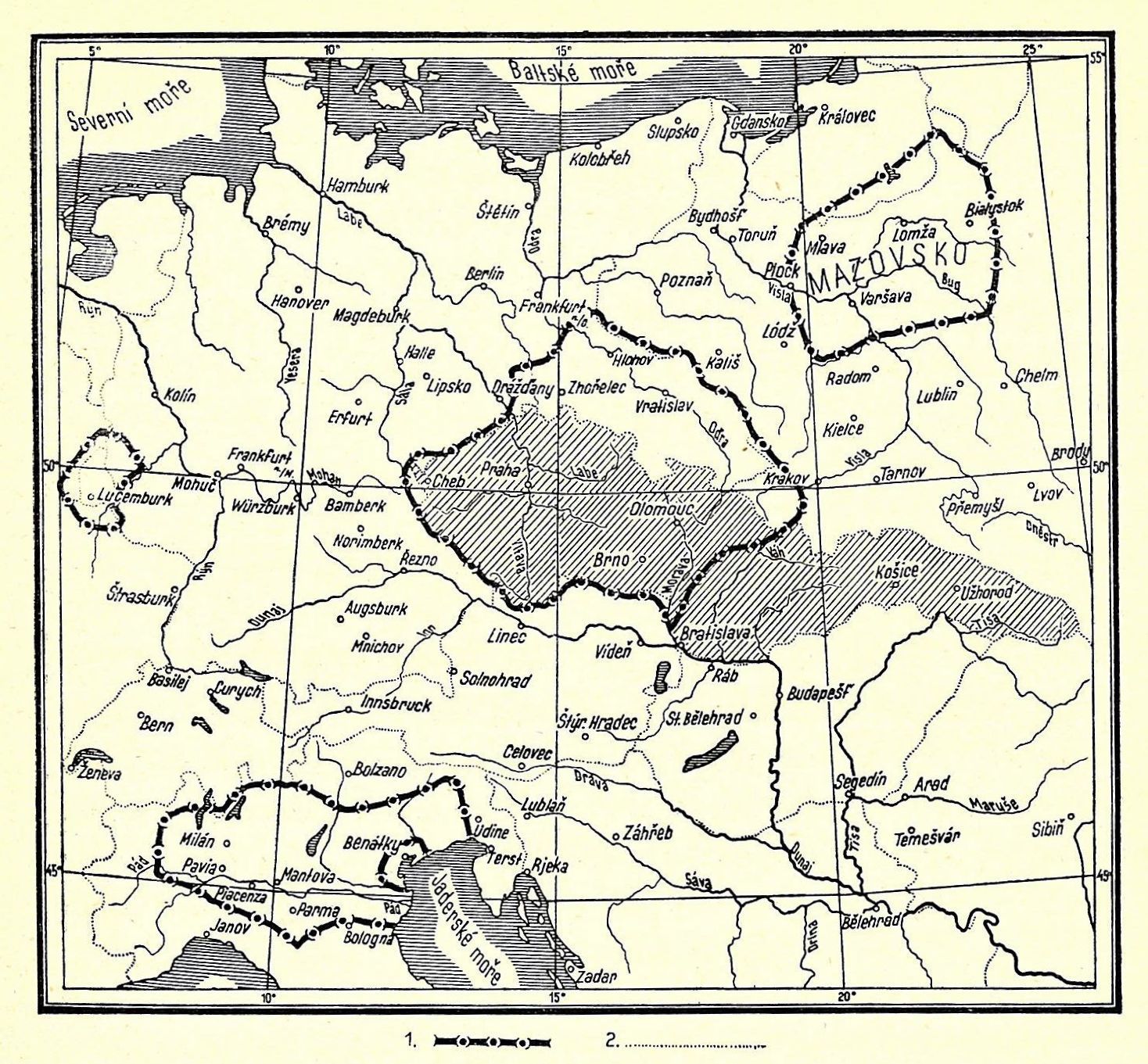
Čeština: Mapa území ovládaného českými králi za Jana Lucemburského. (1. hranice českých zemí a zemí připojených, 2. hranice států v době vydání knihy.)
English: Map showing territory ruled by the Bohemian kings during the reign of John of Bohemia - first half of the 14th century. (1. borders of the Czech lands and lands attached, 2. existing borders of states in 1937.) |
| Date | |
| Source | František Kurfürst: Válečné dějiny československé, Šolc a Šimáček, Praha, 1937 |
| Author | Unknown author |
Licensing[edit]
|
This is a faithful photographic reproduction of a two-dimensional, public domain work of art. The work of art itself is in the public domain for the following reason:
The official position taken by the Wikimedia Foundation is that "faithful reproductions of two-dimensional public domain works of art are public domain". This photographic reproduction is therefore also considered to be in the public domain in the United States. In other jurisdictions, re-use of this content may be restricted; see Reuse of PD-Art photographs for details. {{PD-Art}} template without license parameter: please specify why the underlying work is public domain in both the source country and the United States
(Usage: {{PD-Art|1=|deathyear=''year of author's death''|country=''source country''}}, where parameter 1= can be PD-old-auto, PD-old-auto-expired, PD-old-auto-1996, PD-old-100 or similar. See Commons:Multi-license copyright tags for more information.) | ||||
File history
Click on a date/time to view the file as it appeared at that time.
| Date/Time | Thumbnail | Dimensions | User | Comment | |
|---|---|---|---|---|---|
| current | 22:04, 11 October 2009 | | 1,468 × 1,361 (456 KB) | Alfie983 (talk | contribs) | {{Information |Description={{cs|1=Mapa území ovládaného českými králi za Jana Lucemburského. (1. hranice českých zemí a zemí připojených, 2. hranice států v době vydání knihy.)}} {{en|1=Map showing territory ruled by the Bohemian kings |
You cannot overwrite this file.
File usage on Commons
The following 2 pages use this file:
File usage on other wikis
The following other wikis use this file:
- Usage on be.wikipedia.org
- Usage on cs.wikipedia.org
- Usage on de.wikipedia.org
- Usage on en.wikipedia.org
- Usage on eo.wikipedia.org
- Usage on id.wikipedia.org
- Usage on ka.wikipedia.org
- Usage on pl.wikipedia.org
- Usage on ro.wikipedia.org
- Usage on ru.wikipedia.org
- Usage on sl.wikipedia.org
- Usage on tr.wikipedia.org
- Usage on uk.wikipedia.org