File:Montenegro1941 1944 map.png
Jump to navigation
Jump to search

Size of this preview: 487 × 599 pixels. Other resolutions: 195 × 240 pixels | 390 × 480 pixels | 724 × 891 pixels.
Original file (724 × 891 pixels, file size: 52 KB, MIME type: image/png)
Captions
Captions
Add a one-line explanation of what this file represents
Summary[edit]
| Description |
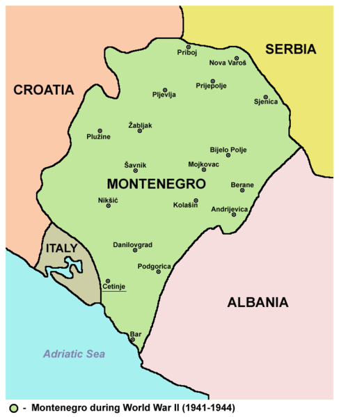
English: Map of Montenegro during World War II (1941-1944).
Српски / srpski: Mapa Crne Gore u toku Drugog svetskog rata (od 1941. do 1944. godine). |
| Date | |
| Source | Own work |
| Author | PANONIAN |
Licensing[edit]
I, the copyright holder of this work, hereby publish it under the following license:
| This file is made available under the Creative Commons CC0 1.0 Universal Public Domain Dedication. | |
| The person who associated a work with this deed has dedicated the work to the public domain by waiving all of their rights to the work worldwide under copyright law, including all related and neighboring rights, to the extent allowed by law. You can copy, modify, distribute and perform the work, even for commercial purposes, all without asking permission.
|
References[edit]
Borders of Montenegro are primarily based on this source:
- Školski istorijski atlas, Zavod za izdavanje udžbenika SR Srbije, Beograd, 1970.
Other secondary sources:
- Istorijski atlas, Geokarta, Beograd, 1999.
- Denis Šehić - Demir Šehić, Školski istorijski atlas Sveta, Beograd, 2007.
- Sve srpske mape - od šestog veka do Pariza, Specijalno izdanje BLICA, Decembar 1995. godine.
- The Times - History of Europe, Times Books, London, 2002.
- Richard Overy, The Times - History of the 20th Century, Times Books, London, 2004.
- Valter Manošek, Holokaust u Srbiji, Beograd, 2007.
- Nenad Stefanović, Jedan svet na Dunavu, Beograd, 2003.
- Dr Tomislav Bogavac, Nestajanje Srba, Niš, 1994.
- Petrit Imami, Srbi i Albanci kroz vekove, Beograd, 2000.
- Tim Džuda, Srbi - istorija, mit i razaranje Jugoslavije, Beograd, 2003.
- Fransisko Veiga, Balkanska zamka (1804-2001), Beograd, 2003.
- Džon R. Lempi, Jugoslavija kao istorija, Beograd, 2004.
- http://www.svetskirat.net/slike/razbijanje/zazbijanje_jugoslavije_1941.jpg
- http://www.marxists.org/subject/yugoslavia/images/maps/1941-dismemberment.jpg
- http://www.srpska-mreza.com/MAPS/Yugoslavia/YU-Nazi-division.jpg
- http://terkepek.adatbank.transindex.ro/kepek/netre/211.gif
- http://terkepek.adatbank.transindex.ro/kepek/netre/330.gif
File history
Click on a date/time to view the file as it appeared at that time.
| Date/Time | Thumbnail | Dimensions | User | Comment | |
|---|---|---|---|---|---|
| current | 09:59, 9 September 2012 | | 724 × 891 (52 KB) | PANONIAN (talk | contribs) | {{Information |Description=Map of Montenegro during World War II (1941-1944). |Source={{own}} |Date=2012 |Author= PANONIAN |Permission= |other_versions= }} |
You cannot overwrite this file.
File usage on Commons
The following 2 pages use this file:
File usage on other wikis
The following other wikis use this file:
- Usage on be.wikipedia.org
- Usage on cs.wikipedia.org
- Usage on fr.wikipedia.org
- Usage on gl.wikipedia.org
- Usage on hr.wikipedia.org
- Usage on nl.wikipedia.org
- Usage on pl.wikipedia.org
- Usage on pt.wikipedia.org
- Usage on sh.wikipedia.org
- Usage on tr.wikipedia.org
- Usage on uk.wikipedia.org