File:Metareas.png
Jump to navigation
Jump to search

Size of this preview: 778 × 600 pixels. Other resolutions: 312 × 240 pixels | 623 × 480 pixels | 997 × 768 pixels | 1,221 × 941 pixels.
Original file (1,221 × 941 pixels, file size: 447 KB, MIME type: image/png)
Captions
Captions
Add a one-line explanation of what this file represents

|
This map image could be re-created using vector graphics as an SVG file. This has several advantages; see Commons:Media for cleanup for more information. If an SVG form of this image is available, please upload it and afterwards replace this template with
{{vector version available|new image name}}.
It is recommended to name the SVG file “Metareas.svg”—then the template Vector version available (or Vva) does not need the new image name parameter. |
Summary[edit]
| Description |
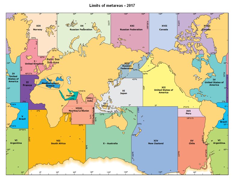
Deutsch: METAREAS Map |
| Source | https://www.navcen.uscg.gov/?pageName=GMDSS |
| Author | USCG |
Licensing[edit]
This image or file is a work of a United States Coast Guard service personnel or employee, taken or made as part of that person's official duties. As a work of the U.S. federal government, the image or file is in the public domain (17 U.S.C. § 101 and § 105, USCG main privacy policy and specific privacy policy for its imagery server).
|
 |
File history
Click on a date/time to view the file as it appeared at that time.
| Date/Time | Thumbnail | Dimensions | User | Comment | |
|---|---|---|---|---|---|
| current | 19:51, 22 November 2020 | | 1,221 × 941 (447 KB) | Rennrigor (talk | contribs) | {{Information |Description= |Source= |Date= |Author= |Permission= |other_versions= }} |
You cannot overwrite this file.
File usage on Commons
There are no pages that use this file.
File usage on other wikis
The following other wikis use this file:
- Usage on de.wikipedia.org