File:Measuring sea-level change ESA22185240.jpg
Jump to navigation
Jump to search

Size of this preview: 800 × 528 pixels. Other resolutions: 320 × 211 pixels | 640 × 422 pixels | 1,024 × 676 pixels | 1,280 × 845 pixels | 2,560 × 1,689 pixels | 17,362 × 11,457 pixels.
Original file (17,362 × 11,457 pixels, file size: 6.71 MB, MIME type: image/jpeg)
Captions
Captions
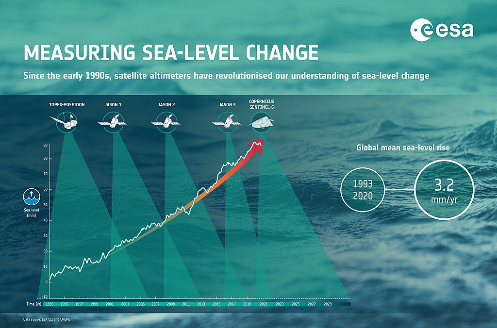
Since the early 1990s, satellite altimeters have revolutionised our understanding of sea-level change.
Summary[edit]
| Warning | The original file is very high-resolution. It might not load properly or could cause your browser to freeze when opened at full size. |
|---|
| Description |
English: Since the early 1990s, satellite altimeters have revolutionised our understanding of sea-level change. With millions of people living in coastal communities around the world, rising seas are at the top of the list of major concerns linked to climate change. Monitoring sea-surface height is critical to understanding the changes taking place so that decision-makers have the evidence to implement appropriate policies to help curb climate change and for authorities to take action to protect vulnerable communities. |
| Date | 1 September 2020 (upload date) |
| Source | Measuring sea-level change |
| Author | European Space Agency |
| Activity | Observing the Earth |
| Keyword | Infographic |
| Mission | Sentinel-6 |
| System | Copernicus |
Licensing[edit]
This media was created by the European Space Agency (ESA).
Where expressly so stated, images or videos are covered by the Creative Commons Attribution-ShareAlike 3.0 IGO (CC BY-SA 3.0 IGO) licence, ESA being an Intergovernmental Organisation (IGO), as defined by the CC BY-SA 3.0 IGO licence. The user is allowed under the terms and conditions of the CC BY-SA 3.0 IGO license to Reproduce, Distribute and Publicly Perform the ESA images and videos released under CC BY-SA 3.0 IGO licence and the Adaptations thereof, without further explicit permission being necessary, for as long as the user complies with the conditions and restrictions set forth in the CC BY-SA 3.0 IGO licence, these including that:
See the ESA Creative Commons copyright notice for complete information, and this article for additional details.
|
 | |
This file is licensed under the Creative Commons Attribution-ShareAlike 3.0 IGO license. Attribution: ESA, CC BY-SA IGO 3.0
| ||
File history
Click on a date/time to view the file as it appeared at that time.
| Date/Time | Thumbnail | Dimensions | User | Comment | |
|---|---|---|---|---|---|
| current | 20:51, 28 March 2024 | | 17,362 × 11,457 (6.71 MB) | OptimusPrimeBot (talk | contribs) | #Spacemedia - Upload of https://www.esa.int/var/esa/storage/images/esa_multimedia/images/2020/09/measuring_sea-level_change/22185230-1-eng-GB/Measuring_sea-level_change.jpg via Commons:Spacemedia |
You cannot overwrite this file.
File usage on Commons
There are no pages that use this file.