File:Mapa de Colombia (red vial).svg
Jump to navigation
Jump to search

Size of this PNG preview of this SVG file: 449 × 600 pixels. Other resolutions: 180 × 240 pixels | 359 × 480 pixels | 575 × 768 pixels | 767 × 1,024 pixels | 1,534 × 2,048 pixels | 1,420 × 1,896 pixels.
Original file (SVG file, nominally 1,420 × 1,896 pixels, file size: 2.24 MB)
Captions
Captions
Add a one-line explanation of what this file represents
Summary[edit]
.svg&action=edit§ion=1)
| Description |
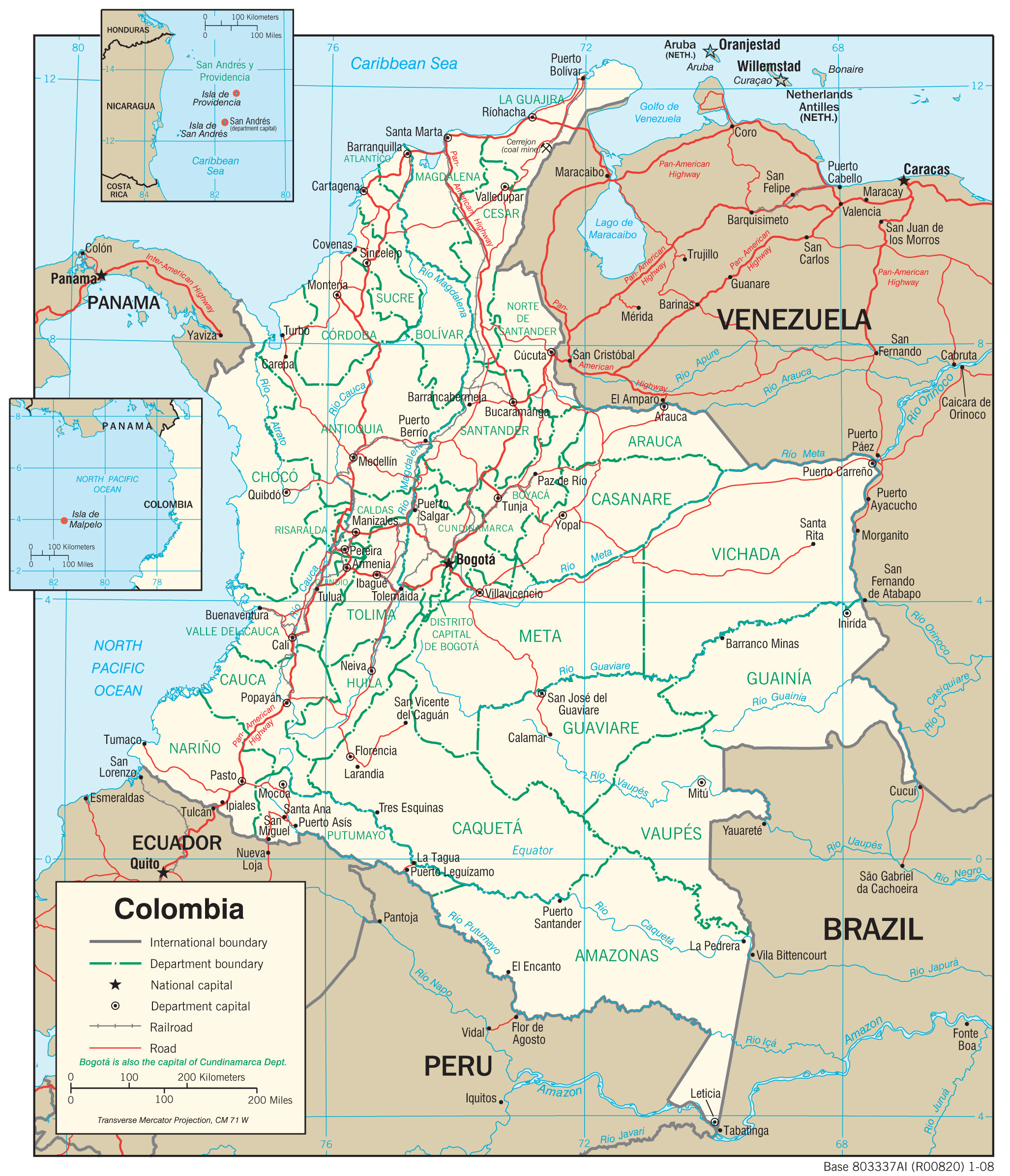
English: Roads of Colombia Español: Red vial de Colombia |
| Date | |
| Source | Own work based on: Colombia Transportation.jpg and Colombia Transportation 2008, Perry-Castañeda Library Map Collection and Mapa de las carreteras colombianas en 2007, UNHCR |
| Author | Milenioscuro |
| Other versions |
Derivative works of this file: |
| SVG development |
Licensing[edit]
.svg&action=edit§ion=2)
Milenioscuro, the copyright holder of this work, hereby publishes it under the following license:
This file is licensed under the Creative Commons Attribution-Share Alike 3.0 Unported license.
Attribution: Milenioscuro
- You are free:
- to share – to copy, distribute and transmit the work
- to remix – to adapt the work
- Under the following conditions:
- attribution – You must give appropriate credit, provide a link to the license, and indicate if changes were made. You may do so in any reasonable manner, but not in any way that suggests the licensor endorses you or your use.
- share alike – If you remix, transform, or build upon the material, you must distribute your contributions under the same or compatible license as the original.
File history
Click on a date/time to view the file as it appeared at that time.
| Date/Time | Thumbnail | Dimensions | User | Comment | |
|---|---|---|---|---|---|
| current | 18:53, 18 February 2022 | | 1,420 × 1,896 (2.24 MB) | Milenioscuro (talk | contribs) | arreglos, relieve, separación de los sistemas |
| 04:56, 20 December 2021 |  | 1,420 × 1,896 (595 KB) | Milenioscuro (talk | contribs) | nuevo esquema | |
| 03:39, 20 December 2021 |  | 1,420 × 1,896 (581 KB) | Milenioscuro (talk | contribs) | nuevo esquema | |
| 12:58, 8 September 2014 |  | 1,422 × 1,898 (857 KB) | Milenioscuro (talk | contribs) | correccions de colores y limites departamentales | |
| 06:04, 24 May 2012 |  | 1,450 × 1,893 (1.08 MB) | Milenioscuro (talk | contribs) | updated | |
| 05:41, 24 May 2012 |  | 1,450 × 1,893 (1.08 MB) | Milenioscuro (talk | contribs) | updated | |
| 01:43, 4 January 2010 |  | 1,301 × 1,708 (1.07 MB) | Milenioscuro (talk | contribs) | numeracion de las vias | |
| 18:59, 2 January 2010 |  | 1,301 × 1,708 (832 KB) | Milenioscuro (talk | contribs) | {{Information |Description={{en|1=Roads of Colombia}} {{es|1=Red vial de Colombia}} |Source={{own}} |Author=Shadowxfox |Date=2010-01-01 |Permission= |other_versions= }} Category:SVG maps of Colombia [[Category:Road maps of Colombi |
You cannot overwrite this file.
File usage on Commons
The following 19 pages use this file:
- Atlas of Colombia
- User:Chumwa/OgreBot/Transport Maps/2021 December 11-20
- User:Chumwa/OgreBot/Transport Maps/2022 February 10-18
- User:Chumwa/OgreBot/Travel and communication maps/2021 December 11-20
- User:Chumwa/OgreBot/Travel and communication maps/2022 February 10-18
- User:Magog the Ogre/Multilingual legend/2021 December 11-20
- User:Magog the Ogre/Multilingual legend/2022 February 10-18
- File:Reseau routier colombien.svg
- File:Ruta Nacional 25.svg
- File:Ruta Nacional 45.svg
- File:Ruta Nacional 45A.svg
- File:Ruta Nacional 49.svg
- File:Ruta Nacional 55.svg
- File:Ruta Nacional 60.svg
- File:Ruta Nacional 62.svg
- File:Ruta Nacional 66.svg
- File:Ruta Nacional 70.svg
- File:Ruta Nacional 80.svg
- File:Ruta Nacional 90.svg
File usage on other wikis
The following other wikis use this file:
- Usage on atj.wikipedia.org
- Usage on de.wikipedia.org
- Usage on en.wikipedia.org
- Usage on es.wikipedia.org
- Anexo:Infraestructuras de transporte de Colombia
- Wikiproyecto:Colombia
- Red Nacional de Carreteras
- Usuario:Alijunakai
- Wikiproyecto Discusión:Colombia/Archivo mayo del 2009 al 16 de mayo del 2016
- Wikiproyecto:Colombia/Carreteras de Colombia
- Wikiproyecto:Colombia/Carreteras de Colombia/Userbox
- Usuario:Nemequene
- Wikiproyecto:Ilustración/Taller de Cartografía/Solicitudes/Archivo1
- Usage on fr.wikipedia.org
- Usage on www.wikidata.org
.svg&oldid=769650230)