File:Map of Arabia 600 AD.svg
Jump to navigation
Jump to search

Size of this PNG preview of this SVG file: 735 × 600 pixels. Other resolutions: 294 × 240 pixels | 588 × 480 pixels | 941 × 768 pixels | 1,255 × 1,024 pixels | 2,509 × 2,048 pixels | 860 × 702 pixels.
Original file (SVG file, nominally 860 × 702 pixels, file size: 1,004 KB)
Captions
Captions
Add a one-line explanation of what this file represents
| Description |
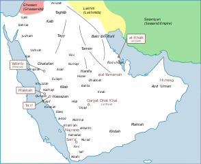
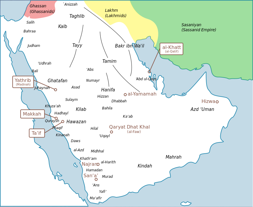
English: a map of arabia with tribes and |
| Date | |
| Source | I created this work entirely by myself, with info from [see below] |
| Author | murraytheb موري (talk) |
| Other versions |
adapted from File:Tribes_english.png  |
| I, the copyright holder of this work, release this work into the public domain. This applies worldwide. In some countries this may not be legally possible; if so: I grant anyone the right to use this work for any purpose, without any conditions, unless such conditions are required by law. |
Original upload log[edit]
The original description page was here. All following user names refer to en.wikipedia.
- 2009-05-25 20:38 Murraytheb 860×702× (966553 bytes) {{Information |Description = a map of arabia with tribes and |Source = I created this work entirely by myself, with info from [see below] |Date = 25 may 2009 |Author = ~~~ |other_versions = adapted from [[File:Tribe
File history
Click on a date/time to view the file as it appeared at that time.
| Date/Time | Thumbnail | Dimensions | User | Comment | |
|---|---|---|---|---|---|
| current | 14:57, 26 March 2024 | | 860 × 702 (1,004 KB) | Haziq Faruqi (talk | contribs) | File uploaded using svgtranslate tool (https://svgtranslate.toolforge.org/). Added translation for ms. |
| 18:51, 26 November 2017 |  | 860 × 702 (967 KB) | Maproom (talk | contribs) | Swapped positions of Ma'afir and 'Ans, as requested by User:Tiwahi at https://commons.wikimedia.org/wiki/User_talk:Maproom#Arabia_600_AD_Map_minor_detail | |
| 16:32, 16 July 2016 |  | 860 × 702 (967 KB) | Maproom (talk | contribs) | Make Persian green not blue to distinguish it from the sea | |
| 16:30, 16 July 2016 |  | 860 × 702 (967 KB) | Maproom (talk | contribs) | Persia green not blue, to distinguish it from the sea | |
| 16:30, 16 July 2016 |  | 860 × 702 (967 KB) | Maproom (talk | contribs) | Persia green not blue, to distinguish it from the sea | |
| 13:28, 21 October 2012 |  | 860 × 702 (967 KB) | ChrisCrea (talk | contribs) | Little updates in the north (sorry cache problems) | |
| 13:26, 21 October 2012 |  | 860 × 702 (965 KB) | ChrisCrea (talk | contribs) | Reverted to version as of 13:10, 21 October 2012 | |
| 13:24, 21 October 2012 |  | 860 × 702 (965 KB) | ChrisCrea (talk | contribs) | Little updates in the north | |
| 13:10, 21 October 2012 |  | 860 × 702 (965 KB) | ChrisCrea (talk | contribs) | Font/text optimization, some new tribes | |
| 00:27, 30 April 2010 |  | 860 × 702 (944 KB) | CambridgeBayWeather (talk | contribs) | {{Information |Description={{en|a map of arabia with tribes and}} |Source=Transferred from [http://en.wikipedia.org en.wikipedia]<br/> (Original text : ''I created this work entirely by myself, with info from from [see below]'') |Date=25 may 2009<br/> ({{ |
You cannot overwrite this file.
File usage on Commons
The following 3 pages use this file:
File usage on other wikis
The following other wikis use this file:
- Usage on azb.wikipedia.org
- Usage on bn.wikipedia.org
- Usage on ca.wikipedia.org
- Usage on de.wikipedia.org
- Usage on de.wikiversity.org
- Usage on en.wikipedia.org
- Usage on eo.wikipedia.org
- Usage on es.wikipedia.org
- Usage on fa.wikipedia.org
- Usage on fr.wikipedia.org
- Usage on fr.wikibooks.org
- Usage on he.wikipedia.org
- Usage on hi.wikipedia.org
- Usage on id.wikipedia.org
- Usage on it.wikipedia.org
View more global usage of this file.
Metadata
Categories:
- Maps of pre-Islamic Arabia
- Thamud
- Banu Bakr
- Banu Kalb
- Banu Tamim
- Banu Taghlib
- Banu Ghatafan
- Banu Hawazin
- Banu Tayy
- Banu Kinda
- Maps of the Ghassanid Kingdom
- Maps of the Lakhmid Kingdom
- Banu Judham
- Banu Khuza'ah
- Banu Udhrah
- Banu Juhaynah
- Banu Thaqif
- Banu Hadhayl
- Banu Kinanah
- Banu Sulaym
- Banu Hilal
- Banu Abbs
- Banu Daws
- Banu Uqayl
- Banu Harith
- Maps of Qatif
- English-language SVG maps showing history